
Herring Run (Blackbird Creek tributary) facts for kids
Quick facts for kids Herring Run |
|
|---|---|

|
|
| Other name(s) | Tributary to Blackbird Creek |
| Country | United States |
| State | Delaware |
| County | New Castle |
| Physical characteristics | |
| Main source | On divide between Herring Run and Appoquinimink River about 0.5 miles east of Townsend, Delaware 70 ft (21 m) 39°23′49″N 075°40′33″W / 39.39694°N 75.67583°W |
| River mouth | Blackbird Creek about 0.5 miles east of H&H Corner, Delaware 0 ft (0 m) 39°23′00″N 075°38′31″W / 39.38333°N 75.64194°W |
| Length | 2.26 mi (3.64 km) |
| Basin features | |
| Progression | southeast |
| River system | Delaware River |
| Basin size | 10.29 square miles (26.7 km2) |
| Tributaries |
|
| Bridges | DE 1, US 13, Union Church Road |
Herring Run is a small stream, about 2.26-mile-long (3.64 km), located in northern Delaware, a state in the United States. It's like a tiny river that flows into a bigger one!
Where is Herring Run?
Herring Run starts its journey east of a town called Townsend, Delaware, in the southern part of New Castle County, Delaware. From there, it flows towards the southeast. Its trip ends when it joins Blackbird Creek, near a place known as H&H Corner.
What is a Watershed?
A watershed is an area of land where all the water, like rain or melting snow, drains into a common point, such as a river, lake, or ocean. Think of it like a giant funnel for water!
Herring Run's Watershed
The land around Herring Run that collects water for it is called its watershed. A big part of this area, about 64%, is used for farming. This means there are lots of fields where crops are grown. About 26% of the watershed is covered by forests, with the rest being other types of land.
This area gets a good amount of rain every year, about 43.4 inches (or 110 centimeters). All this water helps feed the stream and supports the plants and animals living there.
Images for kids
-
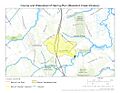
This map shows where Herring Run flows and the area that drains into it.
.jpg)
