Stevensville, Maryland facts for kids
Quick facts for kids
Stevensville, Maryland
|
|
|---|---|

Downtown Stevensville
|
|
 |
|
| Country | United States |
| State | Maryland |
| County | Queen Anne's |
| Area | |
| • Total | 6.44 sq mi (16.68 km2) |
| • Land | 6.44 sq mi (16.68 km2) |
| • Water | 0.00 sq mi (0.00 km2) |
| Elevation | 7 ft (2 m) |
| Population
(2020)
|
|
| • Total | 7,442 |
| • Density | 1,155.23/sq mi (446.06/km2) |
| Time zone | UTC−5 (Eastern (EST)) |
| • Summer (DST) | UTC−4 (EDT) |
| ZIP code |
21666
|
| Area code(s) | 410 |
| FIPS code | 24-75025 |
| GNIS feature ID | 0598122 |
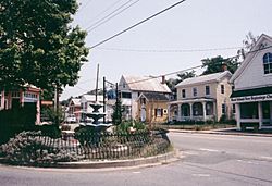
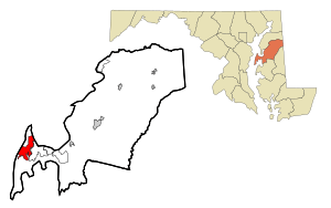
Stevensville is a special kind of community called a census-designated place (CDP) in Queen Anne's County, Maryland. It is the biggest community in Queen Anne's County. Stevensville is where the Chesapeake Bay Bridge ends on the eastern side.
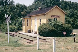
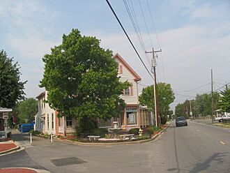
The Stevensville Historic District is a special area with many old buildings. It is one of two registered historic districts in the county. The other is the Centreville Historic District.
Contents
History of Stevensville
Stevensville was started in 1850. It was a place where steamboats would stop. Today, the Stevensville Historic District has about 100 old buildings. These buildings show what the town was like in its early days.
Many historic places in Stevensville are listed on the National Register of Historic Places. These include the Christ Church, Cray House, Friendship, Legg's Dependence, Mattapax, and Stevensville Bank.
On July 24, 2017, a strong tornado hit Stevensville. It was an EF2 tornado. It damaged homes, trees, and power lines. One person was hurt.
Geography and Climate
Stevensville is located at 38°58′52″N 76°19′8″W / 38.98111°N 76.31889°W. It covers an area of about 6.1 square miles (16 square kilometers). All of this area is land.
Weather in Stevensville
The weather in Stevensville has hot and humid summers. Winters are usually mild to cool. This type of weather is called a humid subtropical climate. On climate maps, it is shown as "Cfa".
| Climate data for Stephenville, Maryland (1991–2020 normals, extremes 1926–1942, 1952–1960, 2000–present) | |||||||||||||
|---|---|---|---|---|---|---|---|---|---|---|---|---|---|
| Month | Jan | Feb | Mar | Apr | May | Jun | Jul | Aug | Sep | Oct | Nov | Dec | Year |
| Record high °F (°C) | 75 (24) |
83 (28) |
89 (32) |
92 (33) |
96 (36) |
100 (38) |
101 (38) |
100 (38) |
97 (36) |
98 (37) |
82 (28) |
71 (22) |
101 (38) |
| Mean daily maximum °F (°C) | 42.1 (5.6) |
44.2 (6.8) |
51.9 (11.1) |
63.9 (17.7) |
73.4 (23.0) |
83.1 (28.4) |
87.4 (30.8) |
85.4 (29.7) |
78.2 (25.7) |
67.5 (19.7) |
55.6 (13.1) |
45.7 (7.6) |
64.9 (18.3) |
| Daily mean °F (°C) | 35.4 (1.9) |
36.9 (2.7) |
43.9 (6.6) |
54.9 (12.7) |
64.5 (18.1) |
74.7 (23.7) |
79.5 (26.4) |
77.4 (25.2) |
70.6 (21.4) |
59.1 (15.1) |
48.3 (9.1) |
39.7 (4.3) |
57.1 (13.9) |
| Mean daily minimum °F (°C) | 28.6 (−1.9) |
29.7 (−1.3) |
36.0 (2.2) |
45.9 (7.7) |
55.7 (13.2) |
66.3 (19.1) |
71.5 (21.9) |
69.3 (20.7) |
62.9 (17.2) |
50.8 (10.4) |
41.1 (5.1) |
33.7 (0.9) |
49.3 (9.6) |
| Record low °F (°C) | −1 (−18) |
−9 (−23) |
8 (−13) |
28 (−2) |
34 (1) |
40 (4) |
48 (9) |
48 (9) |
40 (4) |
25 (−4) |
12 (−11) |
7 (−14) |
−9 (−23) |
| Average precipitation inches (mm) | 3.03 (77) |
3.06 (78) |
4.04 (103) |
3.35 (85) |
4.24 (108) |
4.12 (105) |
4.71 (120) |
4.35 (110) |
4.47 (114) |
4.48 (114) |
3.26 (83) |
3.80 (97) |
46.91 (1,192) |
| Source: NOAA | |||||||||||||
People of Stevensville
| Historical population | |||
|---|---|---|---|
| Census | Pop. | %± | |
| 2020 | 7,442 | — | |
| U.S. Decennial Census | |||
In 2010, about 6,803 people lived in Stevensville. There were 2,644 households. This means there were about 1,057 people per square mile.
Most people in Stevensville are White (93.81%). There are also African American (2.32%), Asian (1.57%), and American Indian (0.28%) residents. Some people are from other races (0.73%) or from two or more races (1.57%). About 2.85% of the population is Hispanic or Latino.
Many households (77.4%) had children under 18 living there. Most households (63.4%) were married couples. The average household had 2.84 people. The average family had 3.21 people.
The median age of people in Stevensville was 39.4 years. About 27.5% of the population was under 18 years old. About 8.1% of the population was 65 years or older.
Famous People from Stevensville
- Brock Adams: He used to be a U.S. Secretary of Transportation and a U.S. senator.
- Jay Fleming: A well-known photographer.
- Luke Kleintank: An actor.
- Frank Kratovil: He used to be a U.S. congressman.
- Edward Pipkin: He was a Maryland state senator.
- Frank E. Petersen: He was the first African-American Marine Corps aviator. He was also the first African-American Marine Corps general.
- Paul Reed Smith: He started PRS Guitars and is a famous guitar maker.
Airports in Stevensville
- Bay Bridge Airport (W29) is a small airport in Stevensville. It is owned by the county. It has views of the Chesapeake Bay Bridge. Many private planes use this airport daily.
- Kentmorr Airpark (3W3) is another small airport. It is next to Kentmorr Marina.
See also
 In Spanish: Stevensville (Maryland) para niños
 | Charles R. Drew |
 | Benjamin Banneker |
 | Jane C. Wright |
 | Roger Arliner Young |


