
Kent Island (Maryland) facts for kids
|
Native name:
Monoponson
|
|
|---|---|

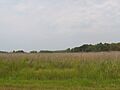
Marshland on Kent Island
|
|

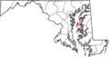
Location within Maryland
|
|

Kent Island
Location in Chesapeake Bay
|
|
| Geography | |
| Location | Chesapeake Bay, Maryland |
| Coordinates | 38°56′55″N 76°18′54″W / 38.94861°N 76.31500°W |
| Area | 31.62 sq mi (81.9 km2) |
| Administration | |
Kent Island is the biggest island in the Chesapeake Bay and a very old, important place in Maryland. It's almost connected to the Delmarva Peninsula on its east side by a narrow waterway called the Kent Narrows. On the other side, it's about four miles (6.4 km) across the water from Sandy Point, near Annapolis. This is the narrowest part of the Chesapeake Bay, and it's where the famous Chesapeake Bay Bridge crosses.
The Chester River flows north of the island and meets the Chesapeake Bay at Kent Island's Love Point. To the south, you'll find Eastern Bay. The island covers about 31.62 square miles (81.9 km2) of land.
Kent Island is part of Queen Anne's County, Maryland, and the Eastern Shore region of Maryland. The first English settlement here, Kent Fort, was started in 1631. This makes Kent Island the oldest English settlement in what is now Maryland. It's also the third oldest permanent English settlement in the United States, after Jamestown, Virginia (1607) and Plymouth, Massachusetts (1620). The towns of Stevensville and Chester are on the island, along with other smaller communities. One of these is Kent Narrows, a fishing community that sits partly on the island. Even though these communities aren't officially incorporated towns, Stevensville and Chester are larger than any of Queen Anne's County's actual towns.
Contents
Discovering Kent Island's Past
Early Days and Colonial Times

For nearly 12,000 years before Europeans arrived, Native Americans lived on Kent Island. The Matapeake people, who were part of the Algonquian nation, called the island Monoponson. The Matapeake area of Kent Island is named after them. Other tribes, like the Ozinie, also visited the island often.
Early European explorers, such as Captain John Smith, saw Kent Island in the 16th and 17th centuries. But it wasn't until August 1631 that the English settled there. William Claiborne, who lived in Jamestown, Virginia, started a trading post near the island's southern end. He named it "the Isle of Kent" after his home in Kent, England.
The first settlement burned down in the winter of 1631–32 but was quickly rebuilt. By 1634, it had a gristmill, a courthouse, and a trading station. When the province of Maryland was formed, Claiborne still thought the island belonged to Virginia. However, Cecilius Calvert, 2nd Baron Baltimore, believed it was part of Maryland. Claiborne left and returned to the island twice before finally leaving in 1658. This ended the arguments over who owned the island. Virginia officially claimed the island until 1776.
Changes During the Industrial Revolution
For a long time, until the early 1800s, Kent Island was mostly used for farming tobacco and corn. But the soil became worn out because farmers didn't rotate their crops or use good farming methods. The island's economy suffered while the soil recovered. Only the port town of Broad Creek kept doing well.
Things started to change around the time of the Industrial Revolution. In 1850, the town of Stevensville was founded. It grew into a major center for steamboat travel across the Chesapeake Bay. Stevensville also had a train station, the Stevensville Train Depot. This station was part of a railroad that carried ferry passengers to other parts of the Eastern Shore.
During this time, small vacation spots were built along the Chesapeake Bay and the Atlantic Ocean. One such resort was at Love Point, north of Stevensville. Farming returned to the island's economy in the 1800s and 1900s. Farmers grew crops like corn, wheat, berries, and melons. Many islanders also became "watermen," working in the growing seafood industry. They caught Maryland Blue Crab, rockfish, and oysters from the Chesapeake Bay.
Kent Island in the 20th Century

As roads became more important than railroads and steamboats in the 1900s, people realized they needed a road bridge to connect the two sides of the Chesapeake Bay. In 1952, the Chesapeake Bay Bridge was finished. This bridge linked Kent Island directly to the Baltimore-Washington Metropolitan Area. The bridge completely replaced the steamboat system and helped Kent Island and the rest of the Eastern Shore grow even more.
In 1973, to handle the increasing traffic, another span was added next to the existing bridge. Then, in the late 1980s and early 1990s, U.S. Route 50 across the island was turned into a freeway.
Recent Times on Kent Island
In September 2003, Hurricane Isabel hit Kent Island and many other places in the Chesapeake Bay Area. Local businesses and old landmarks were damaged or destroyed by the storm and the storm surge (a rise in water level). Most of the damage, mainly from flooding, took several months to fix.
Today, Kent Island is considered a suburb of the Baltimore-Washington Metropolitan Area. Many people have moved there from the Washington, D.C. or Baltimore areas and still travel back to work. Stevensville and Chester are among the most crowded areas on the Eastern Shore. They are also the most crowded in Queen Anne's County.
Historic Places to Explore


As of 2006, many of Kent Island's historic places have been saved. You can see them along the Chesapeake Country Scenic Byway and the American Discovery Trail, which both pass through the island. Several old buildings from the 1800s and earlier are still standing. These include the Cray House, which is a rare example of an old building style. You can also see the old Stevensville post office, the Stoopley Gibson Manor, Christ Episcopal Church, and the Stevensville Train Depot. The Stevensville Historic District and some of its buildings are listed on the National Register of Historic Places.
People from Kent Island
Here are some well-known people who have lived on Kent Island:
- Brock Adams – A former United States Secretary of Transportation and Senator from Washington.
- Elbert N. Carvel – A former Governor of Delaware.
- William Claiborne – The person who founded Kent Island.
- James Earickson – A former State Treasurer of Missouri.
- Henry R. Gibson – A former U.S. representative from Tennessee.
- Theodore N. Lerner – The main owner of the Washington Nationals baseball team.
- Herbert D. Riley – A U.S. Navy Vice Admiral and highly decorated officer. He commanded the USS Makassar Strait and was a World War II veteran of Iwo Jima and Okinawa.
Getting Around Kent Island
Roads for Travel
Most people on Kent Island get around by car, just like in many other suburban areas. The main roads on Kent Island are U.S. Route 50/U.S. Route 301. This freeway connects the island to Central Maryland using the Chesapeake Bay Bridge. It also connects to the Delmarva Peninsula via the Kent Narrows Bridge. Other important roads on the island include Maryland Routes 8, 18, and 552.
Public Transportation Options
On weekdays, the Maryland Department of Transportation offers four bus routes for people who travel to Baltimore or Washington D.C. from Kent Island. There's also a service called "The County Ride," run by the Department of Aging. This service helps older people and those with disabilities get around, but it's also available to the public. It travels to towns like Grasonville, Easton, Centerville, and Annapolis. You can even get door-to-door rides if you ask at least two days in advance.
Walking and Biking Trails
The first part of the Cross Island Trail, a path for walking and biking on Kent Island, was built in the late 1990s. It's part of Queen Anne's County's section of the American Discovery Trail. The full trail was finished in 2001.
After the Cross Island Trail was done, people worried about how safe it was for walkers on the side of Route 8. So, a new trail was planned to run next to the road. This new path, called the Kent Island South Trail, will go from Romancoke Pier at the south end of Route 8. It will head north, crossing the road in Matapeake, near the elementary and middle schools. From there, it will go through Mobray Park, over US 50, and through Stevensville. It will end at the Cross Island Trail in or near Old Love Point Park.
Both the Cross Island and Kent Island South Trails are part of a bigger plan for trails in Queen Anne's County. For now, only the entire Cross Island Trail and the existing part of the Kent Island South Trail are finished.
Connecting to the Mainland

Here are the bridges that connect Kent Island to the mainland, or used to:
- The Chesapeake Bay Bridge, also called the Bay Bridge, crosses the Chesapeake Bay. It carries US 50/301 to Annapolis.
- The Kent Narrows Bridge crosses the Kent Narrows. It carries US 50/301 to the Delmarva Peninsula.
- The Old Kent Narrows Bridge, also known as the Kent Narrows Drawbridge or Route 18 Kent Narrows Bridge, is a drawbridge. It carries Maryland 18 into Grasonville. This bridge was used before the current Kent Narrows Bridge and now helps local traffic.
- An even older car bridge once crossed the Kent Narrows before being replaced by the current Route 18 Kent Narrows Bridge. In the past, railroad bridges also crossed the Kent Narrows. These connected the Kent Island part of the Queen Anne's County Railroad to the mainland.
You can get to Annapolis using MTA Commuter Bus Service Route 210. On weekdays, buses to the mainland start at 5:30 am. The last bus leaving Washington for the island is at 6:48 pm. You can also get to Washington, D.C., using MTA Commuter Bus Service Routes 240 and 250. Weekday service to the mainland starts at 5:00 am for Route 240 and 4:45 am for Route 250. The last bus leaving Washington is at 7:28 pm for Route 240 and 7:08 pm for Route 250.
Local airports on the island also connect to the mainland. The biggest is the Bay Bridge Airport, located near the Chesapeake Bay Bridge. Before the Bay Bridge was built, ferry services connected the island directly to Baltimore, Annapolis, and the small peninsula where St. Michaels is located. Some of the old piers used for the ferry service are still used for fishing today.
Into the 1930s, the Baltimore and Eastern Railroad offered passenger train service. It went from Love Point on the northern tip of the island east to Queenstown, Easton, Hurlock, and Salisbury's Union Station. It also went to Ocean City, Maryland, Berlin, and Delmar, Delaware. However, passenger service ended by 1938.
Images for kids
-
Marshland on Kent Island
-
Location within Maryland
