Templeville, Maryland facts for kids
Quick facts for kids
Templeville, Maryland
|
|
|---|---|

Location of Templeville, Maryland
|
|
| Country | United States |
| State | Maryland |
| Counties | Queen Anne's, Caroline |
| Incorporated | 1865 |
| Area | |
| • Total | 0.06 sq mi (0.14 km2) |
| • Land | 0.06 sq mi (0.14 km2) |
| • Water | 0.00 sq mi (0.00 km2) |
| Elevation | 69 ft (21 m) |
| Population
(2020)
|
|
| • Total | 113 |
| • Density | 2,054.55/sq mi (800.51/km2) |
| Time zone | UTC-5 (Eastern (EST)) |
| • Summer (DST) | UTC-4 (EDT) |
| ZIP code |
21670
|
| Area code(s) | 410 |
| FIPS code | 24-77200 |
| GNIS feature ID | 0591398 |
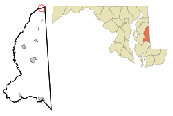
Templeville is a small town in the United States. It is located in Maryland, right near the border with Delaware. The town is split between two counties: Caroline County and Queen Anne's County.
In 2020, about 113 people lived in Templeville. The town used to be called Bullock Town. Its name changed to Templeville in 1847. The new name comes from the Temple family. A famous member of this family was William Temple, who was a governor of Delaware.
Contents
History of Templeville
Templeville was first known as "Bullock Town". In 1847, its name was officially changed to "Templeville". This new name was chosen because of old cemeteries nearby. These cemeteries were linked to the Temple family.
The town was officially made a "municipal corporation" in 1865. This means it became an official town with its own local government. The town's charter, which is like its rulebook, was updated in 1947.
Where is Templeville?
Templeville is located at specific coordinates: 39.136330 degrees North and -75.768398 degrees West. This helps people find it on a map.
The United States Census Bureau says the town is very small. It covers an area of about 0.08 square miles (0.21 square kilometers). All of this area is land, with no water.
Getting Around Templeville
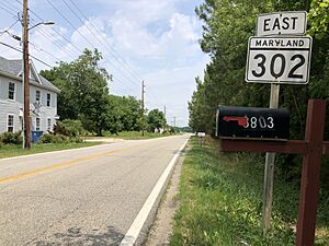
Most people travel to and from Templeville by car. Two main state highways serve the town. Maryland Route 302 goes through the town from east to west. Maryland Route 454 starts in Templeville and heads south. It connects with MD 302 in the town.
Population Changes Over Time
| Historical population | |||
|---|---|---|---|
| Census | Pop. | %± | |
| 1880 | 101 | — | |
| 1950 | 82 | — | |
| 1960 | 98 | 19.5% | |
| 1970 | 102 | 4.1% | |
| 1980 | 96 | −5.9% | |
| 1990 | 66 | −31.2% | |
| 2000 | 80 | 21.2% | |
| 2010 | 138 | 72.5% | |
| 2020 | 113 | −18.1% | |
| U.S. Decennial Census | |||
The population of Templeville has changed over the years. In 1880, there were 101 people. By 1990, it had dropped to 66. However, it grew to 138 people by 2010. In the most recent 2020 census, the population was 113.
Templeville in 2010
In 2010, there were 138 people living in Templeville. These people lived in 39 different homes. Out of these, 27 were families. The town had about 1725 people per square mile. There were 43 housing units in total.
The people living in Templeville came from different backgrounds. About 47.8% were White. About 0.7% were Native American. A large group, 50.7%, were from other races. About 0.7% were from two or more races. A significant part of the population, 60.1%, identified as Hispanic or Latino.
Many homes had children under 18 (43.6%). About 38.5% of homes were married couples. Some homes had a female head of household without a husband (20.5%). Others had a male head of household without a wife (10.3%). About 25.6% of all homes were single individuals. Some people aged 65 or older lived alone (12.9%).
The average number of people in a home was 3.54. For families, the average was 3.89 people. The average age of people in Templeville was 27.3 years. About 27.5% of residents were under 18. About 15.9% were between 18 and 24. Many residents (35.4%) were between 25 and 44. About 14.4% were between 45 and 64. Finally, 6.5% were 65 years or older. The town had slightly more males (50.7%) than females (49.3%).
See also
 In Spanish: Templeville (Maryland) para niños
 | Claudette Colvin |
 | Myrlie Evers-Williams |
 | Alberta Odell Jones |


