
Dorchester County, Maryland facts for kids
Quick facts for kids
Dorchester County
|
|||
|---|---|---|---|

Dorchester County Courthouse and Jail
|
|||
|
|||

Location within the U.S. state of Maryland
|
|||
 Maryland's location within the U.S. |
|||
| Country | |||
| State | |||
| Founded | 1669 | ||
| Named for | Earl of Dorset | ||
| Seat | Cambridge | ||
| Largest city | Cambridge | ||
| Area | |||
| • Total | 983 sq mi (2,550 km2) | ||
| • Land | 541 sq mi (1,400 km2) | ||
| • Water | 442 sq mi (1,140 km2) 45%% | ||
| Population
(2020)
|
|||
| • Total | 32,531 | ||
| • Density | 60.13/sq mi (23.22/km2) | ||
| Time zone | UTC−5 (Eastern) | ||
| • Summer (DST) | UTC−4 (EDT) | ||
| Congressional district | 1st | ||


Dorchester County is a place in Maryland, a state in the United States. In 2020, about 32,531 people lived there. Its main town, or county seat, is Cambridge.
The county started in 1669. It was named after the Earl of Dorset. He was a friend of the Calvert family, who founded the Maryland colony. Dorchester County is part of the Eastern Shore area of Maryland.
Dorchester County is the biggest county in Maryland by its total size. It shares borders with the Choptank River to the north and the Chesapeake Bay to the west. It also borders Talbot County, Caroline County, Wicomico County, and Sussex County, Delaware. The county's slogan is "The Heart of Chesapeake Country." This is because of its location and its heart-like shape on a map.
Contents
History of Dorchester County
For a long time, many people in Dorchester County have worked as watermen or farmers. Watermen are people who make a living from the water. The Chesapeake Bay and its rivers provide lots of crabs, oysters, and fish. Both commercial fishermen and people fishing for fun enjoy these waters.
Dorchester County is famous as the birthplace of Harriet Tubman. She was a brave hero who escaped from slavery. After gaining her freedom, she helped many other enslaved people escape to the North. She used a secret network called the Underground Railroad.
The county has also experienced two strong tornadoes. One happened on June 23, 1944, in Cambridge. Two people died, and 33 were hurt. The other tornado hit Hurlock on May 8, 1984. One person died, and six were injured. Both storms caused a lot of damage to buildings and property.
Geography and Climate
Dorchester County covers a total area of about 983 square miles. About 541 square miles of this is land, and 442 square miles is water. This means that about 45% of the county is water. It is the largest county in Maryland based on its total area.
Weather in Dorchester County
Dorchester County has a humid subtropical climate. This means it has hot, humid summers and mild winters. The average temperature in Cambridge is about 36.1 degrees Fahrenheit in January. In July, the average temperature is around 78.4 degrees Fahrenheit.
Neighboring Counties
Dorchester County is next to several other counties:
- Caroline County (north and northeast)
- Sussex County, Delaware (east)
- Talbot County (north)
- Somerset County (southeast)
- Saint Mary's County (southwest)
- Wicomico County (east and southeast)
- Calvert County (west)
Protected Natural Areas
- Blackwater National Wildlife Refuge is a special area in the county. It protects many kinds of wildlife, especially birds.
Population and People
| Historical population | |||
|---|---|---|---|
| Census | Pop. | %± | |
| 1790 | 15,875 | — | |
| 1800 | 16,346 | 3.0% | |
| 1810 | 18,108 | 10.8% | |
| 1820 | 17,759 | −1.9% | |
| 1830 | 18,686 | 5.2% | |
| 1840 | 18,843 | 0.8% | |
| 1850 | 18,877 | 0.2% | |
| 1860 | 20,461 | 8.4% | |
| 1870 | 19,458 | −4.9% | |
| 1880 | 23,110 | 18.8% | |
| 1890 | 24,843 | 7.5% | |
| 1900 | 27,962 | 12.6% | |
| 1910 | 28,669 | 2.5% | |
| 1920 | 27,895 | −2.7% | |
| 1930 | 26,813 | −3.9% | |
| 1940 | 28,006 | 4.4% | |
| 1950 | 27,815 | −0.7% | |
| 1960 | 29,666 | 6.7% | |
| 1970 | 29,405 | −0.9% | |
| 1980 | 30,623 | 4.1% | |
| 1990 | 30,236 | −1.3% | |
| 2000 | 30,674 | 1.4% | |
| 2010 | 32,618 | 6.3% | |
| 2020 | 32,531 | −0.3% | |
| 2023 (est.) | 32,879 | 0.8% | |
| U.S. Decennial Census 1790-1960 1900-1990 1990-2000 2010–2018 |
|||
Dorchester County does not have a very large population. It is the least densely populated county in Maryland. This means there are fewer people living per square mile compared to other counties.
The biggest town is Cambridge, with about 12,326 people in 2010. Much of Dorchester County is made up of marshlands, forests, and farms.
Population in 2010
In 2010, there were 32,618 people living in Dorchester County. There were 13,522 households, which are groups of people living in one home. About 28.7% of these households had children under 18 years old. The average age of people in the county was 43.3 years.
Education in Dorchester County
Public Schools
- Dorchester County School of Technology
- Choptank Elementary School
- Hurlock Elementary School
- Maple Elementary School
- Sandy Hill Elementary School
- South Dorchester K-8
- Vienna Elementary School
- Warwick Elementary School
- Mace's Lane Middle School
- North Dorchester Middle School
- Cambridge South Dorchester High School
- North Dorchester High School
Media and News
The local newspapers in Dorchester County are The Dorchester Banner and The Dorchester Star. The Dorchester Star is a free newspaper that comes out every week. A larger newspaper called The Star Democrat covers news for several counties in the Mid-Shore area, including Dorchester.
You can also watch local TV stations like WBOC, WMDT, and WRDE-LD. Sometimes, TV stations from Baltimore and Washington, D.C. also cover news here. There is also a local radio station, WHCP-LP (101.5FM). It is run by a local group called Cambridge Community Radio, Inc.
Communities in Dorchester County
City
- Cambridge (This is the county seat, the main town where the county government is located.)
Towns
Census-Designated Places
These are areas that are like towns but are not officially incorporated as cities or towns.
Other Places
- Salem
- Woolford
Famous People from Dorchester County
- Harriet Tubman - A hero who fought against slavery.
- John Barth - A well-known author.
Images for kids
-
Flag of Dorchester County
-
Seal of Dorchester County
-
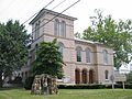
Dorchester County Courthouse and Jail
See also
 In Spanish: Condado de Dorchester (Maryland) para niños
