Vienna, Maryland facts for kids
Quick facts for kids
Vienna, Maryland
|
|
|---|---|

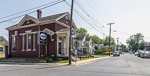
Center of Vienna
|
|
| Motto(s):
"Gateway to the Nanticoke"
|
|

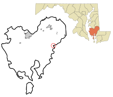
Location of Vienna, Maryland
|
|
| Country | |
| State | |
| County | Dorchester |
| Founded | 1706 |
| Incorporated | 1833 |
| Area | |
| • Total | 0.77 sq mi (1.98 km2) |
| • Land | 0.77 sq mi (1.98 km2) |
| • Water | 0.00 sq mi (0.00 km2) |
| Elevation | 10 ft (3 m) |
| Population
(2020)
|
|
| • Total | 270 |
| • Density | 352.94/sq mi (136.32/km2) |
| Time zone | UTC-5 (Eastern (EST)) |
| • Summer (DST) | UTC-4 (EDT) |
| ZIP code |
21869
|
| Area code(s) | 410 |
| FIPS code | 24-80600 |
| GNIS feature ID | 0591474 |
| Website | Town of Vienna, Maryland |
Vienna is a small town in Dorchester County, Maryland, United States. In 2010, about 271 people lived there. It's known as the "Gateway to the Nanticoke" because it sits on the Nanticoke River.
Contents
History of Vienna
Early Days and Native Americans
Before Europeans arrived, a Nanticoke town called "Chicacone" was located where Vienna is now. The Nanticokes are an Algonquian group. Chicacone was the largest Nanticoke settlement when John Smith explored the Chesapeake Bay in 1608.
By 1742, the Nanticoke people started to leave Chicacone. This was because English settlers often broke agreements about their land. In 1768–69, the Colony of Maryland officially ended the Nanticoke land rights. Many Nanticokes moved north to Pennsylvania, New York, and Canada. Others stayed and became part of the local white or Black communities.
Founding and Early Conflicts
Vienna was founded in 1706. It grew thanks to trade, building ships, and growing tobacco. In 2015, the remains of a 45-foot cargo ship were found under the US 50 Bridge. It was likely built in Maryland and burned by British supporters in the 1780s.
British forces attacked Vienna many times during the American Revolutionary War. They also raided the town during the War of 1812. Because of these attacks, a wall was built along the town's waterfront on the Nanticoke River. Today, this wall is in ruins. A historic place called Handsell was added to the National Register of Historic Places in 2008. Vienna officially became a town in 1833.
Where is Vienna?
Vienna is located at 38°29′7″N 75°49′37″W / 38.48528°N 75.82694°W. The town covers an area of about 0.19 square miles (0.49 km2), which is all land.
People of Vienna
| Historical population | |||
|---|---|---|---|
| Census | Pop. | %± | |
| 1890 | 424 | — | |
| 1910 | 332 | — | |
| 1920 | 257 | −22.6% | |
| 1930 | 311 | 21.0% | |
| 1940 | 385 | 23.8% | |
| 1950 | 414 | 7.5% | |
| 1960 | 420 | 1.4% | |
| 1970 | 358 | −14.8% | |
| 1980 | 300 | −16.2% | |
| 1990 | 264 | −12.0% | |
| 2000 | 280 | 6.1% | |
| 2010 | 271 | −3.2% | |
| 2020 | 270 | −0.4% | |
| U.S. Decennial Census | |||
Population Details
In 2010, there were 271 people living in Vienna. There were 115 households, and 71 of these were families. Most residents (90.8%) were White, and 7.0% were African American. A small number of people were from other racial backgrounds. About 0.7% of the population was Hispanic or Latino.
The average age in Vienna was about 46.9 years old. Almost 20% of the residents were under 18. About 23.6% were 65 years or older. Slightly more than half of the residents (53.1%) were female.
Getting Around Vienna
Roads and Bridges
Several important roads pass through or near Vienna:
- Maryland Route 731 goes right into the center of town. It used to be part of US 50.
- Maryland Route 331 heads north from Vienna towards Rhodesdale.
- U.S. Route 50 now goes around Vienna. This four-lane highway was finished in 1991. It includes the Nanticoke Memorial Bridge, which replaced an older bridge.
Rivers and Buses
Vienna is located on the north side of the Nanticoke River. This river is used by boats. You can also get to Vienna using the Delmarva Community Transit bus service.
Famous People from Vienna
- Josiah Kerr: He was a Republican Congressman from Maryland in the early 1900s.
- Thomas Holliday Hicks: He was the governor of Maryland during the American Civil War.
- James M. Cain: He was a famous author who wrote books like "The Postman Always Rings Twice."
See also
 In Spanish: Vienna (Maryland) para niños
 | Emma Amos |
 | Edward Mitchell Bannister |
 | Larry D. Alexander |
 | Ernie Barnes |

