Wicomico County, Maryland facts for kids
Quick facts for kids
Wicomico County
|
|||
|---|---|---|---|

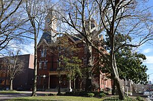
Wicomico County Courthouse in Salisbury
|
|||
|
|||

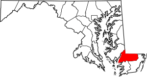
Location within the U.S. state of Maryland
|
|||
 Maryland's location within the U.S. |
|||
| Country | |||
| State | |||
| Founded | 1867 | ||
| Named for | Wicomico River | ||
| Seat | Salisbury | ||
| Largest city | Salisbury | ||
| Area | |||
| • Total | 400 sq mi (1,000 km2) | ||
| • Land | 374 sq mi (970 km2) | ||
| • Water | 26 sq mi (70 km2) 6.4% | ||
| Population
(2020)
|
|||
| • Total | 103,588 | ||
| • Density | 260/sq mi (100/km2) | ||
| Time zone | UTC−5 (Eastern) | ||
| • Summer (DST) | UTC−4 (EDT) | ||
| Congressional district | 1st | ||
Wicomico County (pronounced wy-KOM-ik-oh) is a county in the southeastern part of Maryland. It's located on the Delmarva Peninsula, a large piece of land shared by Delaware, Maryland, and Virginia.
In 2020, about 103,588 people lived here. The main city and county seat is Salisbury. The county gets its name from the Wicomico River. The river's name comes from an old Algonquian language phrase meaning "a place where houses are built." This likely referred to a Native American town that once stood by the river. Wicomico County is also part of the Salisbury, MD-DE Metropolitan Statistical Area.
Contents
Discover Wicomico County's Past
Wicomico County was created in 1867. It was formed from parts of two other counties: Somerset County and Worcester County.
Exploring Wicomico County's Geography
Wicomico County covers a total area of about 400 square miles. Most of this (374 square miles) is land, and 26 square miles (6.4%) is water.
The county shares a border with Delaware. This border includes parts of the famous Mason-Dixon line and the Transpeninsular Line. These lines were surveyed by Charles Mason and Jeremiah Dixon between 1763 and 1767. The county's land is mostly flat, which is common for this region. The lowest parts are at sea level, and the highest point is about 98 feet (30 meters) above sea level.
Neighboring Counties
Wicomico County is surrounded by several other counties:
- Dorchester County, Maryland (to the northwest)
- Somerset County, Maryland (to the southwest)
- Sussex County, Delaware (to the north)
- Worcester County, Maryland (to the southeast)
Major Roads in Wicomico County
Many important roads pass through Wicomico County, helping people travel around.
 US 13
US 13 US 13 Bus.
 US 50
US 50 US 50 Bus.
 MD 12
MD 12 MD 54
MD 54 MD 313
 MD 346
 MD 347
 MD 348
 MD 349
 MD 350
 MD 352
 MD 353
 MD 354
 MD 374
 MD 513
 MD 670
 MD 675
 MD 815
 MD 992
Wicomico County's Climate
The county has a humid subtropical climate. This means it has hot, humid summers and mild winters. The area is also known for its plant hardiness zone 7b, which helps gardeners know what plants can grow well here.
Wicomico County Population Facts
| Historical population | |||
|---|---|---|---|
| Census | Pop. | %± | |
| 1870 | 15,802 | — | |
| 1880 | 18,016 | 14.0% | |
| 1890 | 19,930 | 10.6% | |
| 1900 | 22,852 | 14.7% | |
| 1910 | 26,815 | 17.3% | |
| 1920 | 28,165 | 5.0% | |
| 1930 | 31,229 | 10.9% | |
| 1940 | 34,530 | 10.6% | |
| 1950 | 39,641 | 14.8% | |
| 1960 | 49,050 | 23.7% | |
| 1970 | 54,236 | 10.6% | |
| 1980 | 64,540 | 19.0% | |
| 1990 | 74,339 | 15.2% | |
| 2000 | 84,644 | 13.9% | |
| 2010 | 98,733 | 16.6% | |
| 2020 | 103,588 | 4.9% | |
| 2023 (est.) | 104,800 | 6.1% | |
| U.S. Decennial Census 1790-1960 1900-1990 1990-2000 2010–2018 |
|||
In 2010, Wicomico County had 98,733 people living there. About 37,220 households were counted. The population density was about 263.7 people per square mile. Most residents were white (68.7%), followed by black or African American (24.2%). People of Hispanic or Latino origin made up 4.5% of the population.
The average age in the county in 2010 was 35.7 years old. The median income for a household was $50,752. This means half of the households earned more than this amount, and half earned less.
Education in Wicomico County
Wicomico County has many schools and colleges for students of all ages.
Public Schools
Wicomico County Public Schools manages all the public schools in the county.
Private Schools
There are also several private schools:
- Faith Baptist School
- Salisbury Baptist Academy
- St. Francis de Sales
- Salisbury Christian School
- Stepping Stones Learning Academy
- The Salisbury School
- Wicomico Day School
Colleges and Universities
For higher education, students can attend:
- Salisbury University
- Wor-Wic Community College
Wicomico County's Economy
Wicomico County is home to several important businesses and industries. Perdue Farms, a large company known for poultry and grain, has its main office in Salisbury. Piedmont Airlines is also based here, at the Salisbury–Ocean City–Wicomico Regional Airport.
Other major employers include:
- Salisbury University
- Verizon
- Peninsula Regional Medical Center
- The Knowland Group
- Cadista Pharmaceuticals
- Chesapeake Shipbuilding
- Dove Pointe
- Pepsi Bottling of Delmarva
Other important industries in the county are making electronic parts, pharmaceuticals (medicines), shipbuilding, and agriculture (farming).
Transportation in Wicomico County
Getting around Wicomico County is easy with its major roads and airport.
U.S. 13 runs north and south through the county. U.S. 50 runs east and west.
The Salisbury–Ocean City–Wicomico Regional Airport is the only airport in the area that offers commercial flights. You can fly with American Eagle to cities like Philadelphia, Pennsylvania and Charlotte, North Carolina.
In the past, a train called the Del-Mar-Va Express used to run through Salisbury until 1957.
Media in Wicomico County
Wicomico County has its own newspapers and television stations to keep residents informed.
Newspapers and Magazines
- Coastal Style - a magazine published every two months
- The Daily Times - a daily newspaper
- Metropolitan Magazine - a monthly magazine
- Salisbury Independent - a weekly newspaper
- Salisbury Star - a monthly newspaper
Television Stations
Salisbury is a central point for television in the larger Delmarva area. Most major TV networks have stations based in Salisbury:
- WBOC-TV (CBS, Telemundo, NBC, and Fox)
- WMDT (ABC and The CW)
- Maryland Public Television station WCPB (PBS)
Communities in Wicomico County
Wicomico County has several cities, towns, and smaller communities.
Cities
Towns
Census-Designated Places (CDPs)
These are areas that are like towns but are not officially incorporated.
Unincorporated Communities
These are areas without their own local government.
- Doe Run
- Silver Run
- Wetipquin
- Whiton (partly in Worcester County)
Famous People from Wicomico County
Many notable individuals have connections to Wicomico County:
- Erin Burnett: Born in Mardela Springs, she is a well-known TV host on CNN.
- Joseph Stewart Cottman (1803–1863): Born near Allen, he served as a United States Congressman for Maryland.
- Alexis Denisof: Born in Salisbury, he is an actor known for his roles in TV shows like How I Met Your Mother and Angel.
- Lewis J. Fields: Born in Delmar, he became a United States Marine Corps Lieutenant General.
- John Glover: Raised in Salisbury, he is a famous actor.
- Linda Hamilton: Born in Salisbury, she is an actress best known for her roles in Beauty and the Beast and the The Terminator movies.
- Maulana Karenga: Born and lived in Parsonsburg, he is an activist and professor, best known for creating Kwanzaa.
- Sarah Louise Northcott: Resided in Parsonsburg until her death in 1944.
- Frank Perdue: A former president and CEO of Perdue Farms.
See also
 In Spanish: Condado de Wicomico para niños
 | Stephanie Wilson |
 | Charles Bolden |
 | Ronald McNair |
 | Frederick D. Gregory |


