
St. Mary's County, Maryland facts for kids
Quick facts for kids
St. Mary's County
|
|||
|---|---|---|---|
|
County
|
|||

Reconstructed Blakistone Island Light in 2009
|
|||
|
|||

Location within the U.S. state of Maryland
|
|||
 Maryland's location within the U.S. |
|||
| Country | |||
| State | |||
| Founded | January 24, 1637 | ||
| Named for | Mary the mother of Jesus | ||
| Seat | Leonardtown | ||
| Largest community | California | ||
| Area | |||
| • Total | 764 sq mi (1,980 km2) | ||
| • Land | 357 sq mi (920 km2) | ||
| • Water | 407 sq mi (1,050 km2) 53% | ||
| Population
(2020)
|
|||
| • Total | 113,777 |
||
| • Density | 318.7/sq mi (123.1/km2) | ||
| Time zone | UTC−5 (Eastern) | ||
| • Summer (DST) | UTC−4 (EDT) | ||
| Congressional district | 5th | ||


St. Mary's County was founded in 1637. It is a county in the state of Maryland, USA. In 2020, about 113,777 people lived there. The main town, or county seat, is Leonardtown. The county is named after Mary, the mother of Jesus.
St. Mary's County is part of the Southern Maryland region. It was home to the very first Maryland Colony and its first capital city. English Catholics settled here. It is known as the birthplace of religious freedom in North America. This was important because most other British colonies were settled by Protestants.
Today, the county is home to the Patuxent River Naval Air Station and St. Mary's College of Maryland. For a long time, St. Mary's County was known for its farms, fishing, and crabbing. These activities were part of its unique culture along the Chesapeake Bay.
Over the years, things have changed a lot. Military bases grew, and many companies that work with defense moved in. St. Mary's College also grew. More people who work in Washington, D.C. now live here and travel to work. Because of these changes, the county's population has doubled since 1970.
Contents
History of St. Mary's County
How the Colony Began
The Maryland Colony started when settlers from England arrived. They landed at St. Clement's Island in the Potomac River on March 25, 1634. This day is now celebrated as Maryland Day every year. The settlers traveled on two ships, the Ark and the Dove. They had left the Isle of Wight in England on November 22, 1633.
St. Mary's County is also where the first Catholic Mass was held in one of the original thirteen colonies. This happened after they became English colonies.
St. Clement's Island was too small for a permanent home. So, the settlers looked for a better spot. They chose a high area overlooking the nearby St. Mary's River. This became the first lasting settlement, named "St. Mary's City".
St. Mary's City, Maryland was the first capital of Maryland. It stayed the capital for over 50 years, until 1695. Then, the capital moved to Annapolis.
Religious Freedom in Maryland
In 1649, Lord Baltimore and the Maryland General Assembly passed the Maryland Toleration Act. This law gave religious freedom to all Christians. It was the first law of its kind in the New World.
Today, you can visit Historic St. Mary's City. It is a popular place with four museums. There is a rebuilt colonial village and a copy of the settlers' ship, the Maryland Dove. It is also a top spot for finding old artifacts.
Old Buildings and Memorials
St. Mary's County has some of the oldest buildings still standing in English North America. Many of these old places are listed on the National Register of Historic Places. These buildings come from different times, from the 1600s to the 1800s. There are also important buildings from the early 1900s.
The United States Colored Troops Memorial Statue is in Lexington Park. It honors over 700 African-American soldiers and sailors. These brave people from St. Mary's County fought for the Union during the American Civil War. The memorial has information displays, and special events are held there each year.
Geography and Climate
Where is St. Mary's County?
St. Mary's County covers about 764 square miles. About 357 square miles are land, and 407 square miles are water. This makes it the second-largest county in Maryland by total area.
The county is on the St. Mary's Peninsula. It is mostly surrounded by water. The Patuxent River is to the northeast. The Chesapeake Bay is to the east. The Potomac River is to the southwest. The Wicomico River is to the west.
The coastline has many small bays and inlets. Many parts of the coast have cliffs made of clay and sand. These cliffs help protect the county from big storms. However, some low-lying areas have sandy beaches or marshlands.
The middle part of the county has rolling hills, forests, and farms. There are also flat coastal areas, many of which are used for farming or new buildings. More and more homes have been built here over the past few decades.
The county's many waterways have mostly brackish water. This means it's a mix of fresh and salt water. Near the Chesapeake Bay, the water is saltier. Further inland, the water in rivers and tidal areas has less salt.
Weather in St. Mary's County
St. Mary's County has a humid subtropical climate. This means it has hot, humid summers and mild winters. In Leonardtown, the average temperature in January is about 36.3°F (2.4°C). In July, it's about 78.1°F (25.6°C).
Neighboring Counties
St. Mary's County shares borders with these counties:
- Calvert County (northeast)
- Charles County (northwest)
- Somerset County (southeast)
- Northumberland County, Virginia (south)
- Westmoreland County, Virginia (southwest)
- Dorchester County (east)
St. Mary's County also borders Virginia across the Potomac River. Sometimes, there are disagreements about water rights in these areas.
People and Communities
Population Changes Over Time
The population of St. Mary's County has changed a lot over the years.
| Historical population | |||
|---|---|---|---|
| Census | Pop. | %± | |
| 1790 | 15,544 | — | |
| 1800 | 13,699 | −11.9% | |
| 1810 | 12,794 | −6.6% | |
| 1820 | 12,974 | 1.4% | |
| 1830 | 13,459 | 3.7% | |
| 1840 | 13,224 | −1.7% | |
| 1850 | 13,698 | 3.6% | |
| 1860 | 15,213 | 11.1% | |
| 1870 | 14,944 | −1.8% | |
| 1880 | 16,934 | 13.3% | |
| 1890 | 15,819 | −6.6% | |
| 1900 | 17,182 | 8.6% | |
| 1910 | 17,030 | −0.9% | |
| 1920 | 16,112 | −5.4% | |
| 1930 | 15,189 | −5.7% | |
| 1940 | 14,626 | −3.7% | |
| 1950 | 29,111 | 99.0% | |
| 1960 | 38,915 | 33.7% | |
| 1970 | 48,388 | 24.3% | |
| 1980 | 59,895 | 23.8% | |
| 1990 | 75,974 | 26.8% | |
| 2000 | 86,211 | 13.5% | |
| 2010 | 105,151 | 22.0% | |
| 2020 | 113,777 | 8.2% | |
| 2023 (est.) | 115,281 | 9.6% | |
| =U.S. Decennial Census 1790-1960 1900-1990 1990-2000 2010 2020 |
|||
In 2020, there were 113,777 people living in the county. Most people were White (70.52%), followed by Black or African American (14.06%). About 5.75% of the population was Hispanic or Latino.
Amish and Old Order Mennonite Communities

St. Mary's County is home to an Amish community. They live in the Mechanicsville area. This community has about 1,000 people. The Amish first came here in 1940. They left another Amish community in Lancaster County, Pennsylvania because of disagreements about schooling.
The Amish in St. Mary's County run dairy farms and grow produce. They also have small businesses. There is also an Old Order Mennonite community in the county. This community reaches as far south as Loveville. In recent years, more buildings and development have started to affect the Amish way of life.
Education and Learning
St. Mary's County has several places for learning:
- St. Mary's College of Maryland is in St. Mary's City. It is known as one of the top public liberal arts colleges in the nation.
- The College of Southern Maryland is located in Leonardtown, Maryland.
- The Southern Maryland Higher Education Center is in California, Maryland.
- The Paul Hall Center for Maritime Training and Education is a school for Merchant Marines in Piney Point, Maryland.
The county has three important naval bases:
- "Pax River" is the biggest naval base. Its official name is the Naval Air Station Patuxent River. It is in Lexington Park, Maryland. This base is home to the Naval Air Systems Command and the Naval Test Pilot School. These places are very important to the local economy. Many test pilots who became astronauts, like Alan Shepard and John Glenn, trained here.
- "Webster Field" is a smaller naval area and airfield in Saint Inigoes. It is used for testing and developing airplane electronics.
- Coast Guard Station St. Inigoes is also in Saint Inigoes. It has two separate areas but is run by the same command.
Getting Around: Transportation
Many state highways serve St. Mary's County:
 Maryland Route 4
 Maryland Route 5
 Maryland Route 6
 Maryland Route 234
 Maryland Route 235
 Maryland Route 236
 Maryland Route 237
 Maryland Route 238
 Maryland Route 239
 Maryland Route 242
 Maryland Route 243
 Maryland Route 244
 Maryland Route 245
 Maryland Route 246
 Maryland Route 247
 Maryland Route 249
 Maryland Route 470
 Maryland Route 471
 Maryland Route 472
 Maryland Route 489
 Maryland Route 520
 Maryland Route 584
 Maryland Route 712
 Maryland Route 863
 Maryland Route 868
 Maryland Route 944
 Maryland Route 945
Local buses are available through St. Mary's Transit. There is also a bus service to Washington, D.C., run by MTA. Shuttle services can take you to airports like Baltimore (BWI), Dulles (IAD), and Ronald Reagan (DCA).
The closest major airports are Reagan National Airport in Arlington County, Virginia and Baltimore Washington International Airport near Baltimore. St. Mary's County also has a smaller airport for private planes, called Captain Walter Duke Regional Airport, near California, Maryland.
Towns and Other Places
Main Towns
- Leonardtown (This is the county seat, where the main government offices are.)
Census-Designated Places
These are areas that the Census Bureau recognizes as specific communities:
Other Communities
These are smaller, unincorporated communities in the county:
Places to Visit
St. Mary's County has many interesting places to see:
- Point Lookout State Park: This park has a historic Civil War prison camp. You can also enjoy beaches, fishing, and camping here.
- St. Mary's City: This is where the first Maryland colony began. It has four museums, a rebuilt colonial town, and actors who show what life was like long ago.
- United States Colored Troops Memorial Statue: Located in Lexington Park, this statue honors the African-American soldiers and sailors from St. Mary's County who fought in the Civil War.
- Patuxent River Naval Air Museum: Learn about Naval aviation history and the test pilots who trained at PAX River NAS. Many aircraft are on display.
- Sotterley Plantation: This is a rebuilt old plantation with a museum. It shows what life was like before the Civil War.
- USS Tulip monument: This is a grave site for Civil War sailors who died when a Union gunship exploded in the local waters in 1864.
- Point Lookout Lighthouse
- Piney Point Lighthouse and Museum
- Cecils Old Mill: This museum, art gallery, and artists' co-op is in nearby Great Mills, Maryland.
- Tudor Hall: This is the home of the St. Mary's County Historical Society.
Famous People from St. Mary's County
Many notable people have connections to St. Mary's County:
- Jerome Adams: He was the Surgeon General of the United States from 2017 to 2021.
- William H. Barnes: He received the Medal of Honor for his bravery during the Civil War. He was a free African American farmer from St. Mary's County.
- Margaret Brent: An early English settler in Maryland. She was one of the first women in the English colonies to speak in court.
- Leonard Calvert: He led the first English settlers to Maryland and was the first governor of the Maryland Colony.
- Mary Chapin Carpenter: A Grammy-winning singer and songwriter who has lived in St. Mary's County.
- John Dorsey: A former professional football player and general manager for the Kansas City Chiefs. He was born in Leonardtown.
- Benedict Joseph Fenwick: A Catholic Bishop of Boston in the 1800s, born in Leonardtown.
- Michael Glaser: A poet and educator who was the Poet Laureate of Maryland. He taught at St. Mary's College.
- Alfred Gough: A screenwriter who has written for many Hollywood films. He was born and grew up in Leonardtown.
- Dashiell Hammett: A famous American author of detective novels. He was born in St. Mary's County.
- James H. Harris: He received the Medal of Honor for his bravery during the Civil War. He was an African American Union soldier who grew up in Great Mills.
- Steny Hoyer: A long-serving member of the United States House of Representatives.
- Francis Scott Key: The person who wrote "The Star-Spangled Banner", the national anthem of the United States. He grew up in St. Mary's County.
- Ted Koppel: A well-known journalist and former host of the news show Nightline. He lived in Southern St. Mary's County.
- Sylvester Stallone: A famous actor and director. He attended Charlotte Hall Military Academy in St. Mary's County as a teenager.
- Father Andrew White: A Jesuit priest who helped settle the new Maryland colony. He was important in making peace with the Piscataway Indian tribes.
Images for kids
-
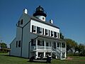
Reconstructed Blakistone Island Light in 2009
-
Seal of St. Mary's County
-
Flag of St. Mary's County
-
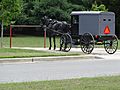
Amish horse and buggy in Mechanicsville
See also
 In Spanish: Condado de Saint Mary para niños
