Algonquin, Maryland facts for kids
Quick facts for kids
Algonquin, Maryland
|
|
|---|---|
 |
|
| Country | |
| State | |
| County | |
| Area | |
| • Total | 2.84 sq mi (7.37 km2) |
| • Land | 0.75 sq mi (1.95 km2) |
| • Water | 2.09 sq mi (5.42 km2) |
| Elevation | 13 ft (4 m) |
| Population
(2020)
|
|
| • Total | 1,220 |
| • Density | 1,624.50/sq mi (627.08/km2) |
| Time zone | UTC−5 (Eastern (EST)) |
| • Summer (DST) | UTC−4 (EDT) |
| ZIP code |
21613
|
| Area code(s) | 410 and 443 and 667 |
| FIPS code | 24-00712 |
| GNIS feature ID | 0596419 |
Algonquin is a special kind of community in Dorchester County, Maryland, United States. It's called a census-designated place (CDP). This means it has a name and a population, but it doesn't have its own local government like a city or town.
In 2010, about 1,241 people lived in Algonquin. The community got its name from the Algonquin people. They were one of the many Native American tribes who lived in the eastern part of the United States.
Where is Algonquin?
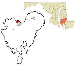
Algonquin is located in the northern part of Dorchester County. It sits right next to the city of Cambridge, which is the main city of the county.
To the north, Algonquin is bordered by the Choptank River. This river is a part of the larger Chesapeake Bay. The water here is tidal, meaning its level changes with the ocean tides.
The total area of Algonquin is about 7.3 square kilometers (2.8 square miles). Most of this area, about 5.4 square kilometers (2.1 square miles), is water. The land area is much smaller, around 1.9 square kilometers (0.75 square miles).
How Many People Live There?
Algonquin is a small community. The number of people living there changes over time.
| Historical population | |||
|---|---|---|---|
| Census | Pop. | %± | |
| 2020 | 1,220 | — | |
| U.S. Decennial Census | |||
According to the 2020 census, there were 1,220 people living in Algonquin.
See also
 In Spanish: Algonquin (Maryland) para niños
 | Toni Morrison |
 | Barack Obama |
 | Martin Luther King Jr. |
 | Ralph Bunche |

