
Talbot County, Maryland facts for kids
Quick facts for kids
Talbot County
|
|||
|---|---|---|---|
    Clockwise: Downtown Easton, Oxford-Bellevue Ferry, Chesapeake Bay Maritime Museum, Third Haven Meeting House.
|
|||
|
|||
| Motto(s): | |||

Location within the U.S. state of Maryland
|
|||
 Maryland's location within the U.S. |
|||
| Country | |||
| State | |||
| Founded | c. 1661 | ||
| Named for | Grace Talbot | ||
| Seat | Easton | ||
| Largest town | Easton | ||
| Area | |||
| • Total | 477 sq mi (1,240 km2) | ||
| • Land | 269 sq mi (700 km2) | ||
| • Water | 208 sq mi (540 km2) 44% | ||
| Population
(2020)
|
|||
| • Total | 37,526 | ||
| • Density | 78.67/sq mi (30.37/km2) | ||
| Time zone | UTC−5 (Eastern) | ||
| • Summer (DST) | UTC−4 (EDT) | ||
| Congressional district | 1st | ||


Talbot County is a county in Maryland, a state in the United States. In 2020, about 37,526 people lived there. Its main town, or county seat, is Easton.
The county is named after Lady Grace Talbot. She was the wife of Sir Robert Talbot, an important person from England and Ireland. She was also the sister of Lord Baltimore, who founded Maryland. Talbot County is located on the "Eastern Shore" part of Maryland.
Talbot County is part of a larger area that includes Washington, D.C. and Baltimore. It shares borders with Queen Anne's County to the north and Caroline County to the east. To the south is Dorchester County, and to the west is the big Chesapeake Bay.
Contents
History of Talbot County
The exact year Talbot County was started is not fully known. But we know it existed by February 12, 1661. That's when an order was sent to its sheriff. At first, the county was split into nine areas called Hundreds. It also had three church areas: St. Paul's, St. Peter's, and St. Michael's.
In 1667, the first important meeting happened at a home near Skipton Creek. This was close to a town called York. Later, in 1709, a new courthouse was built in a different spot. This new location was chosen because York was too far north after Queen Anne's County was formed from part of Talbot County. The new courthouse was near a Quaker Meeting House and faced an old Indian trail, which is now Washington Street in Easton.
After the American Revolutionary War in 1786, a plan was made to create a town around the courthouse. This town was called Talbottown. It had 118 land plots and planned streets. Talbottown soon became known as Easton, the county seat. A bigger courthouse was built on the same spot in 1789. Parts of this building are still inside the current courthouse today.
Important People from Talbot County's Past
Tench Tilghman, a brave soldier who helped George Washington during the Revolutionary War, was born in Talbot County in 1744. He died in 1786 and is buried in Oxford, Maryland. His grave has words praising him as a great friend and a good person.
Founding Father John Dickinson was born in Trappe in 1732. He was important in the early days of the United States. Also, Frederick Douglass, a famous speaker who fought against slavery, was born into slavery near Tuckahoe Creek around 1817 or 1818.
The first hospital on the Eastern Shore was near McDaniel. It was at Dr. Absolom Thompson's farm. Many places in the county are listed on the National Register of Historic Places. This means they are important historical sites.
Talbot County's Great Seal
The official seal of Talbot County was chosen on July 26, 1966. Its design comes from the family symbol of Grace Talbot, who the county is named after.
The seal shows a red lion standing on a silver shield. The background is purple, a color given to Talbot County in 1694. Around the edge, it says "The Great Seal of Talbot County Maryland." Below the lion is a Latin phrase, Tempus Praeteritum Et Futurum. This means "Times, Past and Future."
Historical Sites and Monuments
Third Haven Meeting House
The Third Haven Meeting House was built in 1682 by Quakers, a religious group. Quakers were forced out of Virginia for their beliefs. Lord Baltimore invited them to Maryland. He passed the Maryland Toleration Act, which allowed people to practice different religions.
John Edmondson gave the Quakers land near the Tred Avon River. This land later became the town of Easton, Maryland. The Meeting House is on high ground, surrounded by trees. It is also along an old Indian trail, now Washington Street. George Fox, who started the Quaker movement, visited this place many times. When he died, his personal library was given to the Meeting House. The Third Haven Meeting House might be the oldest wooden building for religious meetings in the United States. People say that Lord Baltimore himself attended a sermon there.
In 1794, parts of the roof were extended to make more room inside. This made the building look a bit uneven. In 1879, a new brick Third Haven Meeting House was built. It is still used today.
St. Joseph Roman Catholic Church
St. Joseph Roman Catholic Church is the oldest Roman Catholic Church on Maryland's Eastern Shore. It still holds church services every week. Father Joseph Mosely, a Jesuit priest, started the church in 1765. It was built on a farm north of Easton in Cordova.
St. Joseph Church was the second Catholic church in Talbot County. The first was a small chapel at Doncaster. Father Mosley wrote about how hard it was to start this church. He said it was a difficult area for priests to visit.
The church had additions built in 1845 and 1903. Father Mosley and other priests are buried under the church floor.
St. Joseph Church hosts an annual Jousting Tournament. This event happens on the first Wednesday of August. It has been held at St. Joseph for over 140 years. Jousting is also Maryland's official state sport.
Longwoods School House
The Longwoods School House is also known as The Little Red School House. It is on Longwoods Road (Route 662) just north of Easton. This school is one of the few old one-room schoolhouses left on the Eastern Shore.
The school opened in 1865 with about 30 students in each class. It held its last class in 1967. People remember walking to school and buying soda at the store across the road. The school used to have two outdoor bathrooms, one for boys and one for girls. Indoor plumbing was added in 1957, and electricity in 1936.
The Talbot Historical Society has restored the schoolhouse. They removed the modern lights and plumbing. They also added the outdoor bathrooms back to make it look like it did originally.
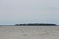
Poplar Island

Poplar Island was one of the first islands in Talbot County to be named and put on a map. Captain William Claibourne named it after Lt. Richard Popeley. It was the first land settled in 1632. The first farms in Talbot County were started on Poplar Island in 1634.
In 1637, Native Americans from the Nanticoke tribe attacked the island. They killed Thompson's family and workers while he was away. Over time, the island's name changed from Popeleys to Poples to Poplar. Today, you can only reach Poplar Island by boat. The Army Corps of Engineers is currently working to rebuild parts of it.
White Marsh Church
In 1691, King William and Queen Mary of England wanted colonists to be more religious. So, the Establishment Act of 1692 divided Talbot County into three church areas for the Church of England. Old White Marsh was one of these. The church was built in Hambleton, a good location for trade.
The original church was likely built between 1662 and 1665. The church was repaired and doubled in size in 1751 because so many people attended. Reverend Thomas Bacon was a popular leader there.
Services at White Marsh ended after the church burned in a brush fire in 1897. Some original items from White Marsh Church are now at St. Paul's Church in Trappe. These include the church's Bible and communion items. You can still see parts of the old brick wall from U.S. Route 50.
The first church leader, Reverend Daniel Maynadier, and his wife are buried inside the church. Robert Morris Sr., a merchant and father of a Founding Father, is buried outside.
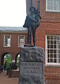
Talbot Boys Monument

From 1916 to 2022, a statue stood in front of the Talbot County Courthouse. It honored men from Talbot County who fought for the Confederate States Army in the American Civil War. The statue showed a young boy holding a Confederate flag. It said: "To the Talbot Boys · 1861–1865 · C.S.A." More than 300 Union soldiers from Talbot County also fought in the war, but they never had a monument.
Like other Confederate monuments, this statue caused debate. Many people felt it honored a side that fought to keep slavery. In 2015, some people wanted it removed, but the County Council voted to keep it. In 2020, after protests about racial justice, there were more calls to remove it. The County Council voted again, but it stayed.
By 2021, it was the only Confederate statue left on public land in Maryland. The ACLU sued the county to have it removed. In September 2021, the County Council finally voted to take it down. It was removed on March 14, 2022. The statue was moved to a battlefield in Virginia.
Frederick Douglass Monument
Near where the Talbot Boys monument used to be, there is a statue of Frederick Douglass. He was an abolitionist who fought against slavery. Douglass was born into slavery near Tuckahoe Creek. He was even held in the jail behind the courthouse after trying to escape slavery in 1836.
The idea for the Douglass statue came from the Talbot Historical Society in 2002. The County Council approved it in 2004. They agreed as long as it was not taller than the Talbot Boys monument.
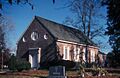
Old Wye Church

A small church called a chapel of ease was likely built near the Wye River after 1692. The current brick church was built between 1717 and 1721. It was changed in the mid-1800s. Then, it was restored to its original style from 1947-1949.
Old Wye Church is still used today. It is one of two churches in Wye Parish. It is the oldest brick church still standing in Talbot County.
Geography of Talbot County
Talbot County covers about 477 square miles. About 269 square miles are land, and 208 square miles (44%) are water. It is the third-smallest county in Maryland by land area.
Neighboring Counties
- Queen Anne's County (north)
- Dorchester County (south)
- Calvert County (southwest)
- Caroline County (east)
- Anne Arundel County (west)
Main Roads
U.S. Route 50 is the most important highway in Talbot County.
Rivers and Creeks
The Choptank River is named after a tribe of Algonquian-speaking Native Americans. These people lived on both sides of the river before English settlers arrived. They were known to be very tall.
The Miles River used to be called Saint Michael's River. In old times, land payments were due on September 29, which is the Feast of St. Michael. So, St. Michael was seen as a special saint for Maryland. Quakers, who lived in Talbot County, did not honor saints. They just called it Michaels River, which slowly became Miles River.
The Wye River forms the northern border of Talbot County. Edward Lloyd, an immigrant from Wales, named it. He owned a lot of land along its southern shores. He named it after the River Wye in Wales, which is known for its winding shape. He also named his home Wye House.
The Tred Avon River gets its name from "Third Haven." The Third Haven Meeting House was built near the river's start in 1682. "Third Haven" might have come from "Thread Haven," an early name for the first port in Oxford, Maryland.
The town of Easton, the county seat, changed its name in 1788. It was named after a town in England called Easton. Many early settlers in Talbot County came from that area in England.
People of Talbot County (Demographics)
| Historical population | |||
|---|---|---|---|
| Census | Pop. | %± | |
| 1790 | 13,084 | — | |
| 1800 | 13,436 | 2.7% | |
| 1810 | 14,230 | 5.9% | |
| 1820 | 14,389 | 1.1% | |
| 1830 | 12,947 | −10.0% | |
| 1840 | 12,090 | −6.6% | |
| 1850 | 13,811 | 14.2% | |
| 1860 | 14,795 | 7.1% | |
| 1870 | 16,137 | 9.1% | |
| 1880 | 19,065 | 18.1% | |
| 1890 | 19,736 | 3.5% | |
| 1900 | 20,342 | 3.1% | |
| 1910 | 19,620 | −3.5% | |
| 1920 | 18,306 | −6.7% | |
| 1930 | 18,583 | 1.5% | |
| 1940 | 18,784 | 1.1% | |
| 1950 | 19,428 | 3.4% | |
| 1960 | 21,578 | 11.1% | |
| 1970 | 23,682 | 9.8% | |
| 1980 | 25,604 | 8.1% | |
| 1990 | 30,549 | 19.3% | |
| 2000 | 33,812 | 10.7% | |
| 2010 | 37,782 | 11.7% | |
| 2020 | 37,526 | −0.7% | |
| 2023 (est.) | 37,823 | 0.1% | |
| U.S. Decennial Census 1790-1960 1900–1990 1990-2000 2010–2018 |
|||
In 2010, there were 37,782 people living in Talbot County. Most people (81.4%) were white. About 12.8% were black or African American. People of Hispanic or Latino origin made up 5.5% of the population.
The average age of people in Talbot County was 47.4 years old. The average income for a household was about $63,017 per year. About 6.1% of all people lived below the poverty line.
Education
Schools in Talbot County are part of the Talbot County Public Schools district. There are also several private schools in the county.
Fun Events
- Waterfowl Festival: A big festival celebrating birds and nature.
- Talbot County Fair: Talbot County held the very first Agricultural Fair in Maryland in 1822.
- Tuckahoe Steam and Gas Association: They have an annual Steam Show after July 4th.
- Plein Air Easton: This is a large art competition where artists paint outdoors. It happens in July.
Media
The local newspaper is The Star Democrat. People in the county can also get TV and radio stations from Baltimore, Salisbury, Maryland, and Washington, D.C..
In 2022, a local radio station, WHCP (91.7 FM), got permission to reach more areas. It can now be heard in most of Talbot County and other nearby counties.
Communities
Towns
- Easton (county seat)
- Oxford
- Queen Anne (partly in Queen Anne's County)
- Saint Michaels
- Trappe
Old Towns (Ghost Towns)
- Doncaster
- Dover
- York
- Wyetown
Census-Designated Places
These are areas that the Census Bureau tracks:
Other Communities
- Anchorage
- Bellevue
- Bozman
- Claiborne
- Copperville
- Doncaster
- Fairbanks
- Lewistown
- Lloyd Landing
- Matthews
- McDaniel
- Neavitt
- Newcomb
- Royal Oak
- Sherwood
- Tunis Mills
- Unionville
- Wittman
- Windy Hill
- Woodland
- Wye Mills
Notable People from Talbot County
Many interesting people have lived in Talbot County, including:
- August Belmont IV: An investment banker and horse owner.
- Bill Veeck: A baseball team owner who helped bring racial integration to the American League.
- Birch Bayh: A former U.S. Senator who helped write Title IX.
- Frederick Douglass: A famous speaker and leader who fought against slavery.
- Harold Baines: A former professional baseball player.
- Harry Hughes: The 57th Governor of Maryland.
- James Wilson Rouse: A real estate developer.
- Maggie Rogers: A popular singer-songwriter.
- Nathaniel Hopkins: A former slave who started Talbot County Emancipation Day. He also founded Trappe's first school for black children.
- Robert Morris, Jr.: One of the people who signed the Declaration of Independence.
- Samuel J. Seymour: He was a witness to the assassination of U.S. President Abraham Lincoln.
- Tench Tilghman: A trusted helper to General George Washington during the Revolutionary War.
Images for kids
-
Poplar Island
-
The "Talbot Boys" Confederate monument outside the county courthouse
-
Old Wye Episcopal Church
See also
 In Spanish: Condado de Talbot (Maryland) para niños
