
Boundary Channel facts for kids
Quick facts for kids Boundary Channel |
|
|---|---|

Map of area surrounding Boundary Channel and the Pentagon Lagoon
|
|
| Country | United States |
| State | District of Columbia |
| Physical characteristics | |
| Main source | Potomac River 0 ft (0 m) 38°53′24.4″N 77°3′49.3″W / 38.890111°N 77.063694°W |
| River mouth | Pentagon Lagoon 0 ft (0 m) 38°52′26″N 77°2′53″W / 38.87389°N 77.04806°W |
| Basin features | |
| River system | Potomac River |
Boundary Channel is a waterway connected to the Potomac River in Washington, D.C.. It starts near the top of Columbia Island. The channel then flows south between Columbia Island and the Virginia shoreline. It curves around the bottom of Columbia Island and heads northeast, rejoining the Potomac River. At the southern end of Columbia Island, Boundary Channel widens into a human-made area called the Pentagon Lagoon.
Contents
How Boundary Channel Was Formed
Columbia Island is a unique place, partly natural and partly built by people. Around 1818, another island nearby, Analostan Island (now Theodore Roosevelt Island), was mostly rock. Over time, the Potomac River changed. Trees were cut down upstream, and more farming happened. This caused the river to erode its northern bank. It also deposited a lot of silt (fine sand or mud) around Analostan Island.
Shaping the Islands and Channel
By 1838, Analostan Island had almost doubled in length to the south. By 1884, this new southern part had become a wetland. However, the river slowly wore away the middle of Analostan Island. This separated Columbia Island from its original larger body.
Between 1911 and 1922, the United States Army Corps of Engineers worked to deepen the Potomac River. This was done to help prevent floods. They used large machines to dig out the river bottom, a process called dredging. This dredging made the space between Analostan/Theodore Roosevelt Island and Columbia Island wider. It also helped build up Columbia Island, making it taller and larger. The new island got its name around 1918 from an engineer. An officer from the Corps of Engineers later named the waterway between Columbia Island and Virginia the "Boundary Channel."
Expanding the Channel for Bridges
Boundary Channel was further shaped in the late 1920s. In 1925, the U.S. Congress approved building the Arlington Memorial Bridge across the Potomac River. The bridge was designed to end on Columbia Island. This meant the island needed to be even bigger.
The Corps of Engineers was already planning more dredging. So, on April 1, 1925, Secretary of War John W. Weeks ordered money to be spent on dredging the river. The dredged material was used to expand Columbia Island. By June 30, 1927, most of this work was finished.
Boundary Channel shows where the original Virginia shoreline used to be. It separates Columbia Island from Virginia. The channel is about one mile long and is part of the Potomac River. In 1936, Boundary Channel was about 100 to 200 feet (30 to 61 m) wide and 4 to 6 feet (1.2 to 1.8 m) deep. There was no large lagoon at that time.
Changes for The Pentagon
Boundary Channel changed again when construction began for The Pentagon on September 11, 1941. The Pentagon was being built on land just south of the channel. The land around the building site was very low. So, General Brehon B. Somervell, who was in charge of building the Pentagon, decided to raise the ground. He wanted it to be at least 8 feet (2.4 m) to 18 feet (5.5 m) higher than the average water level.
To get enough dirt and material to raise the ground, Boundary Channel was dredged and made a bit wider. As of 2013, Boundary Channel is about 100 feet (30 m) wide, though its width changes in different spots. It is also quite shallow.
About Pentagon Lagoon


Pentagon Lagoon is a shallow area that is part of Boundary Channel. It was created when the channel was first built, and it was originally small and didn't have a name.
Building the Lagoon for the Pentagon
During the construction of the Pentagon in 1941, the U.S. Army needed a lot of fill material to raise the land. They also needed a way for barges to bring concrete, gravel, and sand to the building site. Columbia Island was nearby and had unused land. So, the Corps of Engineers removed part of the island and dredged the bottom of the lagoon. This provided the needed fill material.
The Army also built a temporary wall, called a dike, on the Virginia shoreline. The land behind this dike was dug out to be 14 feet (4.3 m) below the Potomac River's average high tide. Near this new shoreline, the Army built cement plants and areas to store sand and gravel. Then, the dike was removed, allowing barges to deliver building materials quickly and cheaply. More than 1,000,000 cubic yards (760,000 m3) of earth and river bottom were dug out. This made Boundary Channel's lagoon much larger, by about 30 acres (120,000 m2).
The The Washington Post newspaper named the area "Pentagon Lagoon" in September 1944. When the Pentagon Lagoon was measured in 2000, its eastern entrance channel was 7.5 feet (2.3 m) deep. Depths of 5 to 8 feet (1.5 to 2.4 m) were common near the Columbia Island Marina, while other parts of the lagoon were 2 to 7 feet (0.61 to 2.13 m) deep.
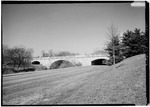
Bridges Over Boundary Channel
Many bridges cross Boundary Channel. Here is a list of them, from south to north:
| Image | Crossing | Opened | Coordinates | Notes |
|---|---|---|---|---|
 |
George Washington Memorial Parkway Mount Vernon Trail |
1932 | 38°52′31″N 77°02′50″W / 38.8754°N 77.0471°W | Also known as Humpback Bridge; it was widened in 2010. |
 |
Footbridge to Lyndon Baines Johnson Memorial Grove | 38°52′44″N 77°03′11″W / 38.8789°N 77.0530°W | ||
 |
1942 | 38°52′49″N 77°03′26″W / 38.8804°N 77.0573°W | ||
 |
George Washington Memorial Parkway southbound | 38°52′51″N 77°03′32″W / 38.88085°N 77.0589°W | ||
 |
Memorial Avenue | 1932 | 38°53′06″N 77°03′42″W / 38.8851°N 77.0616°W | |
 |
Arlington Boulevard | 1949 | 38°53′20″N 77°03′51″W / 38.8889°N 77.0641°W | This bridge replaced an older wooden bridge from 1938. |
 |
George Washington Memorial Parkway northbound | 38°53′24″N 77°03′51″W / 38.8899°N 77.0641°W | ||
| Mount Vernon Trail | 38°53′24″N 77°03′50″W / 38.88995°N 77.0640°W |
