
Interstate 66 facts for kids
Quick facts for kids
|
|
|---|---|
| Lua error in Module:Infobox_road/map at line 15: attempt to index field 'wikibase' (a nil value). | |
| Route information | |
| Length | 76.28 mi (122.76 km) |
| Major junctions | |
| West end | |
| East end | |
| Highway system | |
| Main route of the Interstate Highway System Main • Auxiliary • Business |
|

Interstate 66 (often called I-66) is a major highway in the United States. It is part of the Interstate Highway System, which connects cities across the country. This road helps people travel easily between places.
I-66 starts in Middletown, Virginia, in the western part of the state. It then travels east, going through several towns and counties. The highway ends in Washington, D.C., the nation's capital. The entire route is about 76.28 miles (122.76 kilometers) long.
Traveling on I-66
Interstate 66 is a very busy road, especially for people commuting to and from Washington, D.C. It passes through important areas in Virginia. These include Front Royal, Virginia, Warrenton, Virginia, and Fairfax, Virginia.
Connecting to Other Roads
I-66 connects with many other important highways. In Middletown, it links up with Interstate 81. Near Washington, D.C., it crosses Interstate 495, also known as the Capital Beltway. These connections help drivers reach many different destinations.
Using the Highway
Like many major highways, I-66 has special lanes. Some sections have "HOV" (High Occupancy Vehicle) lanes. These lanes are for cars with multiple passengers. This helps reduce traffic and encourages carpooling. There are also projects to improve the highway. These projects aim to make travel smoother and faster for everyone.
Images for kids
-
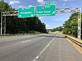
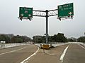
I-66's western starting point in Middletown, Virginia, where it meets I-81.
-
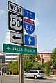
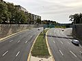
A view looking east along the E Street Expressway, just past I-66.
-

This picture from 2006 shows I-66 in Fairfax County, Virginia. You can see the Metrorail Orange Line trains in the middle of the highway. The left lane was for HOV, and the right shoulder was used as a regular lane during busy times. This part of the road is being made wider.
-
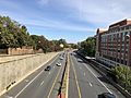
Looking east on I-66 near Scott Street in Arlington.
-
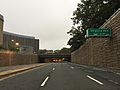
How to get onto I-66 going west in Rosslyn, Arlington County, Virginia.
-

I-66 heading east, past the exit for US 29 in Centreville.
-
A view looking "west" (which is actually south) at the end of I-66, where it meets US 29 in Washington, D.C.
-
The Potomac River Freeway, which is part of I-66, in Washington, D.C.
-

A map of I-66, showing the cities it passes through and where it connects with I-81 and I-495.
_in_Warren_County,_Virginia.jpg)
_and_23rd_Street_NW_in_Washington,_D.C..jpg)

_from_the_overpass_for_North_Scott_Street_in_Arlington_County,_Virginia.jpg)

_in_Centreville,_Fairfax_County,_Virginia.jpg)
_at_the_eastern_end_of_Interstate_66_(Potomac_River_Freeway)_in_Washington,_D.C..jpg)
_from_the_overpass_for_Triangle_Park-Virginia_Avenue-New_Hampshire_Avenue-25th_Street_in_Washington,_D.C..jpg)
See also
 In Spanish: Interestatal 66 para niños
