Middletown, Virginia facts for kids
Quick facts for kids
Middletown, Virginia
|
|
|---|---|

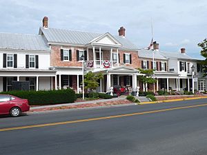
The Wayside Inn (1797) in Middletown
|
|

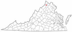
Location of Middletown, Virginia
|
|
| Country | United States |
| State | Virginia |
| County | Frederick |
| Area | |
| • Total | 0.78 sq mi (2.01 km2) |
| • Land | 0.78 sq mi (2.01 km2) |
| • Water | 0.00 sq mi (0.00 km2) |
| Elevation | 715 ft (218 m) |
| Population
(2010)
|
|
| • Total | 1,265 |
| • Estimate
(2019)
|
1,396 |
| • Density | 1,801.29/sq mi (695.44/km2) |
| Time zone | UTC−5 (Eastern (EST)) |
| • Summer (DST) | UTC−4 (EDT) |
| ZIP code |
22645
|
| Area code(s) | 540 |
| FIPS code | 51-51512 |
| GNIS feature ID | 1495940 |
Middletown is a small town in Frederick County, Virginia. It is located in the northern part of the beautiful Shenandoah Valley. In 2010, about 1,265 people lived in Middletown. The town's population grew from 1,015 people in 2000.
Contents
History of Middletown
Middletown officially became a town on May 4, 1796. The first records of the area date back to the late 1700s. They mention Dr. Peter Senseney and his wife Magdelen. They were German settlers who moved from Pennsylvania. The town was first called "Senseney Town." This land was part of a large grant given in the 1600s.
Historic Places and Events
Belle Grove Plantation is a historic site near Middletown. It was first settled around 1750. Its main house, built in the Federal style, was finished in 1797. Middletown was important during the American Civil War. The Battle of Cedar Creek was fought just south of the town. Today, this battle area is protected as part of the Cedar Creek and Belle Grove National Historical Park.
The town has a long history, even before the Civil War. The Wayside Inn in Middletown is very old. It claims to be the longest continuously running inn in America. The Wayside Theatre was also in Middletown. It was one of Virginia's oldest professional live theaters. It opened in 1963 and closed in 2013. Middletown is also home to Laurel Ridge Community College.
Many other historic places in Middletown are listed on the National Register of Historic Places. These include Long Meadow, the Middletown Historic District, Fort Bowman, Monte Vista, Old Forge Farm, and St. Thomas Chapel. In 2012, Charles Hamilton Harbaugh IV was elected mayor of Middletown. He was only 24 years old, making him the youngest mayor in Virginia's history. He was reelected in 2016.
Geography of Middletown
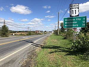
Middletown is located in the southern part of Frederick County. It is in the Shenandoah Valley region. The town is about 5 miles (8 km) southwest of Stephens City. It is also about 13 miles (21 km) southwest of Winchester. Strasburg is 5 miles (8 km) northeast. Washington D.C. is about 80 miles (129 km) to the west.
Town Area and Water
According to the United States Census Bureau, Middletown covers a total area of about 0.78 square miles (2.0 square kilometers). Most of this area is land. Only a very small part, about 0.008 square miles (0.02 square kilometers), is water. The town sits on a ridge. This ridge is between Meadow Brook to the northwest and streams that flow into Molly Booth Run to the southeast. Middletown is part of the area where water flows into the North Fork of the Shenandoah River.
Climate in Middletown
Middletown has a Humid Subtropical climate. This means it has hot and humid summers. The winters are cool with some snow. In January, the average low temperature is about 22.9°F (minus 5.1°C). In July, the average high temperature is about 86.9°F (30.5°C). The town usually gets about 23.2 inches (59 cm) of snow each year. The total rainfall averages about 40.2 inches (102 cm) per year.
Transportation in Middletown
U.S. Route 11, also known as Main Street, goes right through the middle of Middletown. It runs from northeast to southwest. This road mainly helps people get to and from nearby Interstate 81. Exit 302 on I-81 connects with Reliance Road. This road is just east of Middletown and gives direct access to the town.
Interstate 81 is a major highway. It goes north to parts of West Virginia, Maryland, Pennsylvania, and New York. It also goes southwest to Tennessee. South of Middletown, I-81 connects with Interstate 66. Interstate 66 goes east towards Washington, D.C..
Population of Middletown
| Historical population | |||
|---|---|---|---|
| Census | Pop. | %± | |
| 1880 | 372 | — | |
| 1890 | 410 | 10.2% | |
| 1900 | 423 | 3.2% | |
| 1910 | 363 | −14.2% | |
| 1920 | 354 | −2.5% | |
| 1930 | 416 | 17.5% | |
| 1940 | 361 | −13.2% | |
| 1950 | 386 | 6.9% | |
| 1960 | 378 | −2.1% | |
| 1970 | 507 | 34.1% | |
| 1980 | 841 | 65.9% | |
| 1990 | 1,061 | 26.2% | |
| 2000 | 1,015 | −4.3% | |
| 2010 | 1,265 | 24.6% | |
| 2019 (est.) | 1,396 | 10.4% | |
| U.S. Decennial Census | |||
The census of 2000 showed that 1,015 people lived in Middletown. There were 409 households and 280 families. The town had about 1,852 people per square mile (712.5 per square kilometer). There were 432 houses or apartments.
Most people in Middletown were White (about 93.69%). About 4.43% were African American. A small number of people were Native American, Asian, or Pacific Islander. About 0.79% of the population was Hispanic or Latino.
In 2000, about 35.5% of households had children under 18 living with them. About 49.1% were married couples. About 14.2% were single mothers. The average household had 2.48 people. The average family had 2.96 people.
The population was spread out by age. About 26.7% were under 18 years old. About 32.9% were between 25 and 44 years old. About 11.5% were 65 years or older. The average age in the town was 36 years.
The average income for a household in Middletown was $36,538. For families, the average income was $42,031. About 7.6% of the people in Middletown lived below the poverty line. This included 4.9% of those under 18 and 11.9% of those 65 or older.
See also
 In Spanish: Middletown (Virginia) para niños
 | Tommie Smith |
 | Simone Manuel |
 | Shani Davis |
 | Simone Biles |
 | Alice Coachman |


