
Stephens City, Virginia facts for kids
Quick facts for kids
Stephens City, Virginia
|
|
|---|---|
|
Incorporated town
|
|

Intersection of Routes 11 and 277 in the center of town
|
|

Location in Frederick County, Virginia
|
|

Stephens City, Virginia
Location in the United States
|
|
| Country | United States |
| State | Virginia |
| County | Frederick |
| Founded | October 12, 1758 |
| Founded by | Lewis Stephens |
| Named for | The Stephens family |
| Area | |
| • Total | 2.46 sq mi (6.36 km2) |
| • Land | 2.43 sq mi (6.28 km2) |
| • Water | 0.03 sq mi (0.08 km2) |
| Elevation | 764 ft (233 m) |
| Population
(2020)
|
|
| • Total | 2,016 |
| • Estimate
(2022)
|
2,096 |
| • Density | 850.37/sq mi (328.37/km2) |
| Demonym(s) | Stephens Citian |
| Time zone | UTC−5 (EST) |
| • Summer (DST) | UTC−4 (EDT) |
| ZIP code |
22655
|
| Area code(s) | 540 |
| FIPS code | 51-75344 |
| GNIS feature ID | 1500159 |
Stephens City is a town in Frederick County, Virginia, United States. In 2020, about 2,016 people lived there. By 2022, the population was estimated to be 2,096.
The town was started by Peter Stephens in the 1730s. It was officially named for his son, Lewis Stephens, in October 1758. The first settlers were German Protestants from Heidelberg.
Stephens City is the second oldest town in the Shenandoah Valley. Only Winchester, about 5 miles (8 km) north, is older. In the 1850s, a community for free African Americans called "Crossroads" was founded nearby. This community lasted until the American Civil War.
During the Civil War, in 1864, Union Major Joseph K. Stearns saved Stephens City from being burned down. The town has had a few names over time, including "Stephensburg" and "Newtown". Today, Interstate 81 and U.S. Route 11 pass near or through the town.
A large part of the town center, including old buildings and homes, is now a historic area. It is called the Newtown–Stephensburg Historic District. This area was added to the National Register of Historic Places in 1992. Stephens City celebrated its 250th birthday on October 12, 2008.
Contents
Exploring the History of Stephens City
How Stephens City Began: Early Settlers and Growth
For 12,000 years, Native American tribes lived in the area around Stephens City. These included the Susquehannock, Lenape, and Shawnee. When European settlers arrived, the tribes were peaceful at first. But problems started when land and resources were taken.
In the 1600s, King Charles II of England gave a large piece of land in Virginia to the ancestors of Thomas Fairfax, 6th Lord Fairfax of Cameron. Later, in 1730, John and Isaac Vanmeter bought a part of this land. Baron Jost Hite then bought this land in 1731.
Jost Hite was a rich Protestant immigrant from Germany. In 1732, he moved south with his family and other German and Scotch-Irish families. They settled near Opequon Creek. One of these men, Peter Stephens, received 674 acres (273 ha) of land. He built a log house about 2 miles (3.2 km) south of Hite's settlement. Peter Stephens was also a German Protestant from Heidelberg.
Peter's house was built near a stream called Crooked Run. His family and other settlers soon joined him. His oldest child, Lewis, ran a tavern at the family home. Lewis bought more land in the 1740s and 1750s. By 1755, he owned 900 acres (364 ha).
During the French and Indian War, Lewis Stephens decided to create a town. He wanted a central place where people could gather for protection. In 1754, he started planning the town. It had many small and large lots. On October 12, 1758, the Virginia government officially approved the town. It was named "Stephensburgh." This made it the second oldest town in Frederick County.
The town's residents mostly spoke German. They soon dropped the "h" from Stephensburgh, calling it "Stephensburg." By the time of the American Revolutionary War, it was often called "New Town" or "Newtown." This was because it was a new settlement on the important Great Wagon Road. During the Revolutionary War, local fighters from Newtown joined the Continental Army.
Growth and Challenges: From Newtown to Stephens City
Newtown continued to grow after the Revolutionary War. By the 1790s, the town expanded, and its first post office opened. Newtown was in a great location, where the Valley Pike met a road connecting Alexandria to the Cumberland Gap. This road is now Route 277. Because of all the traffic, making wagons became a big business in town. Many shops made wagons that were sold all over Virginia.
By 1830, about 800 people lived in Newtown. In 1853, free African Americans started a settlement nearby called "Crossroads" or "Freetown." This community lasted until the American Civil War. After the Emancipation Proclamation in 1863, some newly freed slaves worked for the Union army. Many free African Americans also left the area.
When the Civil War began in 1861, most young men from Newtown joined the Confederate army. During the war, the town was often caught between the two sides. On May 24, 1862, Confederate forces attacked Union troops near Newtown. Control of the town changed hands six times that day.
In June 1864, Union Major Joseph K. Stearns was ordered to burn the town. This was to stop Confederate attacks on the roads. But Major Stearns saw that only women, children, and older people were left. So, he decided not to burn the town. He made the adult residents take an oath saying they had not helped the Confederacy.
After the war, in 1867, a railroad line was built. This connected Newtown to the rest of the country by train. The railroad helped the local economy, but it also hurt the wagon-building business. In 1880, the United States Post Office Department wanted to change the town's name. There were too many "Newtowns" in Virginia. They first suggested "Pantops," then "Newtonfield." The townspeople didn't like either name. So, they chose "Stephens City."
Stephens City in the 20th Century and Today
In the early 1900s, limestone was found west of Stephens City. A lime plant was built, creating an industrial area called "Mudville." This area grew to include other businesses. In 1915, electricity came to town. In 1941, a water system was installed.
Passenger train service ended in 1949. Also, a big fire in 1936 damaged many buildings in Mudville. These events led to the decline of that part of town.
The building of Interstate 81 in the early 1960s changed Stephens City. The old wagon road, now U.S. Route 11, used to bring traffic through the town center. But the new interstate passed just east of town. This pulled businesses and shoppers away from downtown. New homes were built near I-81, attracting people who commuted to work. In 1964, the town got a sewer system and its first stoplight. A permanent town hall opened in 1978.
To protect its history, the town looked at its old buildings. The Newtown–Stephensburg Historic District was added to the National Register of Historic Places in 1992. This district includes many buildings from the 1700s, 1800s, and early 1900s.
In 1964, schools in Frederick County, including those serving Stephens City, were ordered to end segregation. In 1994, Virgil E. Watson became the first African American to serve on the Stephens City Town Council.
The lime plant closed in 2003, ending about 100 years of limestone production. In 2004, a tornado from Hurricane Ivan hit south of town. It caused about $1 million in damage.
Today, renovating the historic center has attracted heritage tourism. The town has grown, adding hundreds of new homes. In 2022, voters approved a plan to turn the old school into a new town hall and community center.
Where is Stephens City? Geography and Climate
Location of Stephens City
Stephens City is located in the northern Shenandoah Valley of Virginia. It sits between the Blue Ridge Mountains and the Appalachian Mountains. It is also close to West Virginia, Maryland, and Pennsylvania. Washington, D.C. is about 70 miles (113 km) to the east. Baltimore is about 105 miles (169 km) to the northeast.
The town covers about 2.46 square miles (6.36 km2). Most of this area is land, with a small amount of water. Water within the town flows into Stephens Run, which goes to the Shenandoah River. It also flows into Opequon Creek, which goes to the Potomac River.
Weather in Stephens City
Stephens City has four distinct seasons. Its climate is typical for the Mid-Atlantic U.S., away from large bodies of water. The town is in plant hardiness zone 7, meaning it has a mild climate.
Spring and fall are warm with low humidity. Winters are cool, with about 15 inches (38 cm) of snow each year. Average winter lows are around 30 °F (−1 °C). Big snowstorms, called blizzards, happen about every four to six years. Strong nor'easter storms bring high winds, heavy rain, and sometimes snow.
Summers are hot and humid. High temperatures average in the upper 80s °F (lower 30s °C). Lows average in the upper 60s °F (lower 20s °C). The hottest temperature ever recorded was 107 °F (42 °C) in 1988. The coldest was −18 °F (−28 °C) in 1983.
| Month | Jan | Feb | Mar | Apr | May | Jun | Jul | Aug | Sep | Oct | Nov | Dec | Year |
|---|---|---|---|---|---|---|---|---|---|---|---|---|---|
| Average high °F (°C) | |||||||||||||
| Average high | 40.8 | 44.7 | 53.9 | 64.8 | 74.2 | 82.6 | 87.1 | 85.7 | 78.8 | 67.5 | 56.2 | 45.7 | 65.2 |
| Average low | 20.0 | 22.2 | 30.3 | 38.5 | 48.7 | 57.3 | 62.0 | 60.1 | 52.9 | 40.6 | 32.5 | 24.5 | 40.8 |
| Highest recorded | 80 (1950) |
80 (1985) |
89 (1989) |
93 (1960) |
97 (2013) |
104 (2010) |
107 (1988) |
105 (2010) |
103 (1953) |
95 (1986) |
85 (1950) |
80 (2001) |
107 (1988) |
| Lowest recorded | −18 (1983) |
−16 (1996) |
−6 (1993) |
18 (1950) |
28 (1966) |
36 (1986) |
42 (1988) |
36 (1982) |
30 (1983) |
16 (1988) |
9 (1986) |
−6 (1989) |
−18 (1983) |
| Precipitation (inches) | |||||||||||||
| Monthly Average | 2.66 | 2.40 | 3.33 | 3.01 | 3.93 | 4.10 | 3.66 | 3.60 | 3.59 | 3.16 | 3.06 | 2.60 | 39.10 |
| Highest monthly | 5.92 (1978) |
5.67 (1998) |
8.36 (1993) |
7.07 (1987) |
9.40 (1988) |
12.67 (1972) |
7.35 (1978) |
7.89 (1975) |
11.31 (1999) |
9.01 (1976) |
7.33 (1997) |
5.55 (1973) |
12.67 (1972) |
| Snowfall (inches) | |||||||||||||
| Monthly Average | 7.9 | 6.7 | 2.4 | 0.2 | 0.0 | 0.0 | 0.0 | 0.0 | 0.0 | trace | 1.0 | 2.3 | 20.5 |
| Highest monthly | 35.0 (2016) |
33.0 (2010) |
17.0 (1984) |
3.0 (1971) |
0.0 | 0.0 | 0.0 | 0.0 | 0.0 | trace (1974) |
9.5 (1971) |
16.3 (1973) |
35.0 (2016) |
| Sources: Notes: Temperatures are in degrees Fahrenheit. Precipitation includes rain and melted snow or sleet in inches; median values are provided for precipitation and snowfall because mean averages may be misleading. Mean and median values are for the 30-year period 1971–2000; temperature extremes are for the station's period of record (1900–2001). The station is located in 7 miles southeast of Winchester at approximately 39°6′1.45″N 78°10′49.29″W / 39.1004028°N 78.1803583°W and at 732 ft (223 m) in elevation. | |||||||||||||
People and Economy of Stephens City
Who Lives in Stephens City? Demographics
| Historical population | |||
|---|---|---|---|
| Census | Pop. | %± | |
| 1880 | 479 | — | |
| 1890 | 443 | −7.5% | |
| 1900 | 490 | 10.6% | |
| 1910 | 483 | −1.4% | |
| 1920 | 481 | −0.4% | |
| 1930 | 606 | 26.0% | |
| 1940 | 600 | −1.0% | |
| 1950 | 676 | 12.7% | |
| 1960 | 876 | 29.6% | |
| 1970 | 802 | −8.4% | |
| 1980 | 1,179 | 47.0% | |
| 1990 | 1,186 | 0.6% | |
| 2000 | 1,146 | −3.4% | |
| 2010 | 1,829 | 59.6% | |
| 2020 | 2,016 | 10.2% | |
| 2022 (est.) | 2,096 | 14.6% | |
In 2020, Stephens City had 2,016 people living in 802 households. This was a 10.2% increase from 2010. The population was estimated to be 2,096 in 2022.
Most residents (86%) are White. About 10.3% are African American. Other groups include Native American (3.2%), Asian (2.8%), and people of other races (7.3%). Hispanics or Latinos make up 8.4% of the population.
Most people (82.7%) speak only English at home. About 16.1% speak Spanish.
In 2020, 31.5% of households had children under 18. About 39.9% were married couples. The average household had 2.51 people. The median age in town was 36.1 years. The median income for a household was $80,625 in 2021.
Many residents have German (10.7%), English (7.6%), or Irish (7.5%) backgrounds. These reflect the early settlers of the town.
What Jobs Do People Have? Economy and Work
Stephens City has a diverse economy. Many people work in education, healthcare, and social services (28.2%). Retail trade (13.5%) and manufacturing (11.4%) are also important.
About 76.3% of people in Stephens City are employed. Most (80.9%) are in the civilian workforce. About 19.1% work for the federal government. A small number (2.5%) are self-employed.
Fun Things to Do: Culture and Recreation

Parks and Places to Play
Stephens City has two parks: Newtown Commons and Bel Air Street Park. Newtown Commons, also called Newtown Park, is on Main Street. It's a great place for picnics, fundraisers, or small concerts. Bel Air Street Park has a playground for children with swings and other activities.
Just outside town is Sherando Park. This larger park has trails, ponds, a pool, and sports fields. It also has the Virginia Tech Memorial Garden. This garden remembers the 32 victims of the Virginia Tech shooting. It has a winding sidewalk shaped like "VT" and a flagpole with 32 stones.
The Family Drive-In Theatre is a two-screen drive-in movie theater near town. It's on U.S. Route 11 south of Stephens City. It's one of only ten drive-ins left in Virginia.
Yearly Events and Festivals
Stephens City hosts the "Newtown Heritage Festival" every Memorial Day weekend. This three-day event has crafts, carnival food, and local music at Newtown Commons. There's also a parade and fireworks.
Stephens City is also part of the "Route 11 Yard Crawl." This yearly event happens on the second Saturday in August. It's an almost 50-mile-long (80 km) yard sale. It stretches from Newtown Commons south along U.S. Route 11 to New Market, Virginia.
Churches and Faith in Town

The first organized church in Stephens City was a Reformed church. Lutherans started worshipping in town in 1770. For a while, both groups shared a log cabin church. Services were in German until the 1820s. The current Trinity Lutheran Church was built in 1906.
Methodism came to Stephens City in 1775. The first Methodist group west of the Blue Ridge Mountains started here. Early members included the Stephens and Hite families. In 1790, a "spacious chapel" was built. The current Stephens City United Methodist Church was built in 1913.
Orrick Chapel is the oldest church building still standing. It was built between 1866 and 1869 for an African Methodist Episcopal group. This church helped newly freed people after the Civil War. Other churches in town include a non-denominational church and a Full Gospel church.
Just south of town, there is a Mennonite church and a Unitarian Universalist church. Larger churches and a Jewish synagogue for the whole Shenandoah Valley are in nearby Winchester.
Learning and Getting Around: Education and Transportation
Schools Near Stephens City
Frederick County Public Schools operate the public schools that serve Stephens City. No public schools are right inside the town. Schools that serve the area include:
- Bass-Hoover Elementary School
- Robert E. Aylor Middle School (in White Post)
- Sherando High School
There are also two private schools nearby: Eukarya Christian Academy and Legacy Christian Academy. For higher education, residents can go to Shenandoah University in Winchester or Laurel Ridge Community College in Middletown.
How to Get Around: Transportation
_just_south_of_Barley_Drive_in_Stephens_City,_Frederick_County,_Virginia.jpg)
Historic U.S. Route 11 (Main Street) goes through Stephens City. Interstate 81 is just east of town. State Route 277 (Fairfax Street) starts in Stephens City. It ends about 4.72 miles (7.6 km) away in Double Tollgate.
Other main streets in town include Barley Drive, German Street, and Mulberry Street (north-south). Locust Street, School Street, and Short Street/Steele Court (east-west).
There are plans to move State Route 277 closer to the Family Drive-In Theatre. This will also move the I-81 exit at Stephens City. This will help reduce traffic. The town expects to grow more to the south.
Stephens City does not have public transportation. However, there are plans for bicycle trails and sidewalks. These will connect to Sherando Park and other areas. The closest train station is in Martinsburg, West Virginia. The nearest major airport is Dulles International Airport, about an hour east.
Town Services: Utilities and Healthcare
Frederick Water provides water and sewer services in Stephens City. The town also offers free trash collection every week. Electricity is provided by Rappahannock Electric Cooperative. Shenandoah Gas Company provides natural gas.
The closest hospitals are Winchester Medical Center and Warren Memorial Hospital. Both are run by Valley Health. Urgent care centers are also available in Winchester, Front Royal, and Strasburg.
Famous People from Stephens City
- Timothy T. O'Donnell, an author, professor, and former president of Christendom College.
- Kelley Washington, a player in the National Football League.
Images for kids
-
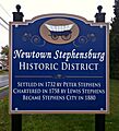
Signage upon entering the town's Newtown–Stephensburg Historic District
-
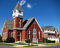
Stephens City United Methodist Church

See also
 In Spanish: Stephens City (Virginia) para niños
