
History of state highways in Virginia facts for kids
 
Primary and secondary State Route shields
|
|

The system used from 1923 to 1928 involved two-digit routes (red) with three- and four-digit spurs (orange). District 1 (Bristol) is shown here.
|
|
Quick facts for kids System information |
|
|---|---|
| Length: | 57,867 mi (93,128 km) |
| Notes: | Outside cities, some towns, and two counties, every road is state-maintained. These roads are split into primary and secondary State Routes, and receive different levels of funding. Inside cities, most primary State Routes are locally maintained. |
| Highway names | |
| Interstates: | Interstate X (I-X) |
| US Routes: | U.S. Route X (US X) |
| System links | |
| Virginia Routes Primary • Secondary • History • Turnpikes |
|
The History of State Highways in Virginia is all about how Virginia built and organized its roads over time. It started in 1906 when the state created the State Highway Commission. This group was in charge of planning and taking care of Virginia's main roads.
In 1918, the state government, called the General Assembly, decided on a big system of state highways. It was about 4,000 miles (6,441 km) long! The commission was responsible for keeping these roads in good shape. Every year, they could add more roads to the system.
At first, highways were numbered from 1 to 20. Some roads that branched off, called "spurs," had letters added to their numbers, like "7X." In 1923, the state changed the numbers. Routes 1 to 9 became 31 to 39. The spur roads also got new numbers instead of letters, like 114 instead of 11X. Some very long numbers, like 1010, were used for branches of branches.
Contents
How Roads Got Their Numbers
The First Big Changes (1926-1928)
In 1926, a new system called United States Numbered Highways was created across the country. These are the well-known "U.S. Routes" you see today, like U.S. Route 1.
Because of these new U.S. Routes, Virginia changed its state highway numbers again in 1928. This time, the numbers for spur roads started with the number of their district. For example, a spur in District 1 might be numbered 114. Even if a state route was also a U.S. Route, the state still referred to it by its state number, even if the signs only showed the U.S. Route number.
The Byrd Road Act and Secondary Roads (1932)
In 1932, a very important law called the Byrd Road Act was passed. It was promoted by former Governor Harry F. Byrd. This law created the "Secondary System" of roads. These are the smaller, local roads in counties.
The law gave counties the choice to let the state take over maintaining their local roads. Most counties agreed to this. However, cities in Virginia, which are called "independent cities," were not included. They had to keep taking care of their own roads. This showed that Governor Byrd and his political group cared more about rural areas.
Only four out of more than 90 counties decided not to join the state system at first.
- Nottoway County joined the state system in 1933.
- Warwick County later became an independent city and then merged with Newport News.
- By the late 1900s, only Arlington and Henrico Counties still maintained their own roads.
Usually, when an area became part of an independent city, the state stopped maintaining its secondary roads. The city then became responsible for them. But there was a special exception for Nansemond County. It became an independent city in 1972 and then merged with Suffolk in 1974. Because of a special agreement, the Virginia Department of Transportation (VDOT) kept maintaining Suffolk's secondary roads until 2006.
More Renumbering (1933-1958)
When VDOT took over road maintenance from most counties in 1932, they created the "state secondary system." These new secondary routes were given numbers starting from 600.
Because of this, the primary state routes were renumbered again in 1933. This time, each district got a smaller range of numbers. State routes that had numbers similar to U.S. Routes were changed to avoid confusion.
Some of the old state routes got new numbers:
- State Route 2 became State Route 50.
- State Route 3 became parts of State Routes 37 and 827.
- State Route 4 became many different routes, including part of State Route 17.
- State Route 5 became State Route 41, part of State Route 39, and State Route 835.
- State Route 6 became part of State Route 18 and State Route 19.
- State Route 7 became parts of State Routes 37 and 54 and all of State Route 822.
- State Route 8 became State Route 23.
- State Route 9 became State Route 25.
Only State Route 10 is still around from the very first 1918 system, though it has changed a lot. State Route 35 is mostly the same as the original State Route 5, which was renumbered in 1923.
There were two more renumberings after this. One happened in 1940, when routes that ended at state borders were renumbered to match the numbers in the next state. Another renumbering happened in 1958, when routes that had numbers similar to the new Interstate Highways were changed.
Images for kids
-
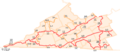
The system used from 1923 to 1928 involved two-digit routes (red) with three- and four-digit spurs (orange). District 1 (Bristol) is shown here.
