Fort Hunt, Virginia facts for kids
Quick facts for kids
Fort Hunt, Virginia
|
|
|---|---|

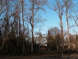
Houses along Fort Hunt Rd., seen from Fort Hunt Park
|
|

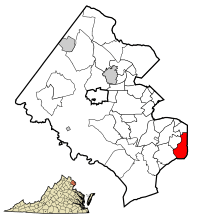
Location of Fort Hunt in Fairfax County, Virginia
|
|
| Country | United States |
| State | Virginia |
| County | Fairfax |
| Area | |
| • Total | 6.27 sq mi (16.23 km2) |
| • Land | 5.85 sq mi (15.16 km2) |
| • Water | 0.41 sq mi (1.07 km2) |
| Elevation | 33 ft (10 m) |
| Population
(2020)
|
|
| • Total | 17,231 |
| • Density | 2,748.2/sq mi (1,061.7/km2) |
| Time zone | UTC−5 (Eastern (EST)) |
| • Summer (DST) | UTC−4 (EDT) |
| ZIP code |
22308
|
| FIPS code | 51-29136 |
| GNIS feature ID | 1867588 |
Fort Hunt is a special kind of community in Fairfax County, Virginia, United States. It's called a census-designated place (CDP). This means it's an area that the government counts as a community for statistics, even though it's not officially a city or town.
The area gets its name from Fort Hunt, a historic place built way back in 1897. This fort was built along the Potomac River to protect Washington, D.C. from attacks by ships. Today, it's a popular public park where people can visit.
Fort Hunt is known for being home to many older adults. It was also one of the first neighborhoods to grow in the wealthy Fairfax County area. In 2020, about 17,231 people lived here.
The Fort Hunt area includes the 22308 ZIP code of Alexandria. It covers many nice neighborhoods in southeast Fairfax County. These include Riverside Gardens, Waynewood, and Stratford Landing. It's very close to the George Washington Memorial Parkway and the Potomac River.
Contents
Where is Fort Hunt?
Fort Hunt is located in the southeastern part of Fairfax County. It sits right by the Potomac River, which forms the border with Maryland.
38°43′58″N 77°3′29″W / 38.73278°N 77.05806°W
Nearby communities in Virginia include Belle Haven to the north and Mount Vernon to the southwest. The total area of Fort Hunt is about 16.2 square kilometers (6.25 square miles). Most of this is land, with a small part being water.
Inside Fort Hunt, you'll find Fort Hunt Park. This park is managed by the National Park Service. It has a long military history, going all the way back to 1676.
Fort Hunt's Past
Early Military Use
The land where Fort Hunt Park is today has been important for the United States military for a long time. It was first used during the Spanish–American War in 1898. The fort was finished on land that used to be part of George Washington's River Farm.
Fort Hunt was built to work with Fort Washington, which is across the river in Maryland. Even though it was ready for battle, Fort Hunt was not actually involved in any fighting during the Spanish–American War.
World War II and Beyond
During World War II, Fort Hunt had a secret job. It was used as a special place to question captured German officers. This secret center was known as P. O. Box 1142.
A sad event happened here during the war. Lieutenant Commander Werner Henke was the highest-ranking German officer to be shot while being held by Americans during World War II.
After the war, the area around the fort began to grow. New neighborhoods like Waynewood and Snowden were built. The Hollin Hall shopping center, which became a main place for the community, was also built on Fort Hunt Road.
People of Fort Hunt
Population and Diversity
In 2020, there were 17,231 people living in Fort Hunt. The area has about 1,061 people per square kilometer (2,748 people per square mile).
Most people in Fort Hunt are White (about 84%). There are also people of African American, Asian, Native American, and Pacific Islander backgrounds. About 9% of residents are from two or more races. Around 6.8% of the population is Hispanic or Latino.
Families and Age
Most families in Fort Hunt are married couples (about 72.6%). The average family has about three people.
The average age of people in Fort Hunt is 46.2 years old. About 25.6% of the people are under 18 years old. Also, 20.8% of the people are 65 years old or older.
Education and Income
Many people in Fort Hunt have a good education. About 79% of adults have a college degree or higher.
The average income for a household in Fort Hunt was about $209,135. For families, the average income was even higher, around $234,343. This shows that Fort Hunt is a well-off community.
Only a small number of people (1.8%) live below the poverty line. This includes 1.1% of those under 18 and 2.7% of those 65 or older.
See also
 In Spanish: Fort Hunt (Virginia) para niños
 | Laphonza Butler |
 | Daisy Bates |
 | Elizabeth Piper Ensley |


