Mount Vernon, Virginia facts for kids
Quick facts for kids
Mount Vernon, Virginia
|
|
|---|---|

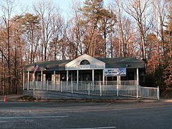
Mount Vernon post office (2009)
|
|

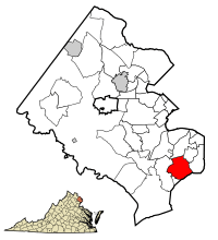
Location of Mount Vernon in Fairfax County, Virginia
|
|
| Country | United States |
| State | Virginia |
| County | Fairfax |
| Named for | Mount Vernon |
| Area | |
| • Total | 6.07 sq mi (15.7 km2) |
| • Land | 5.24 sq mi (13.6 km2) |
| • Water | 0.83 sq mi (2.1 km2) |
| Elevation | 69 ft (24 m) |
| Population
(2020)
|
|
| • Total | 12,914 |
| • Density | 2,127.5/sq mi (821.4/km2) |
| Time zone | UTC−5 (Eastern (EST)) |
| • Summer (DST) | UTC−4 (EDT) |
| ZIP code |
22309, 22121
|
| Area code(s) | 703, 571 |
| FIPS code | 51-54144 |
| GNIS feature ID | 2391234 |
Mount Vernon is a special kind of community in Fairfax County, Virginia, United States. It is called a census-designated place (CDP) because the government tracks its population. In 2020, about 12,914 people lived there.
Many people visit Mount Vernon each year. They come to see its important historical sites and enjoy its beautiful nature. Over one million tourists visit this area annually.
The name "Mount Vernon" comes from the famous home of George Washington. This home is south of Alexandria, Virginia. Locally, the name "Mount Vernon" often refers to the entire area between Old Town Alexandria and Fort Belvoir. However, the official CDP area is smaller. It is bordered by the Potomac River to the south, Fort Belvoir to the west, U.S. Route 1 to the north, and Little Hunting Creek to the east.
Contents
History of Mount Vernon
The land that makes up the Mount Vernon area was once part of the large farms of George Washington and his wife, Martha Washington. They owned a huge estate called Mount Vernon.
Over time, much of this land was given away. George and Martha Washington made wishes in their wills to donate land to the public. Some land also went to people connected to the Washington family. For example, the nearby Woodlawn Plantation was given to Martha Washington's granddaughter, Eleanor Parke Custis Lewis.
The Gum Springs part of the area was started by formerly enslaved people. These were often individuals who had gained their freedom from the Mount Vernon Estate and nearby areas.
In 2010, the U.S. Census Bureau changed how it defined Mount Vernon. The part of Mount Vernon north of U.S. Route 1 became its own separate CDP called Woodlawn. This change made Mount Vernon's land area smaller and reduced its population by more than half.
Geography and Location
Mount Vernon is located at coordinates 38°44′07″N 77°05′43″W / 38.7351590°N 77.0953670°W. It sits about 69 feet (24 meters) above sea level. You can find Mount Vernon on U.S. Route 1 in Northern Virginia.
It is about 13 miles (21 km) south-southwest of downtown Washington, D.C.. It is also 13 miles (21 km) southeast of Fairfax, which is the county seat.
Mount Vernon is on the Atlantic Coastal Plain, right on the north side of the Potomac River. Two small streams flow south through the area into the river. Dogue Creek runs through the western part of Mount Vernon. Little Hunting Creek forms the eastern border of the community.
The United States Census Bureau says that Mount Vernon covers a total area of 6.07 square miles (15.72 square kilometers). Of this, 5.24 square miles (13.57 square kilometers) is land, and 0.83 square miles (2.15 square kilometers) is water. This means about 14% of the area is water.
Mount Vernon is a suburb of Washington, D.C. This means it is part of the larger Washington Metropolitan Area. It is also part of the even bigger Baltimore-Washington Metropolitan Area. Mount Vernon shares borders with other nearby communities. These include Woodlawn and Hybla Valley to the north. To the east is Fort Hunt. Across the Potomac River to the southeast are Accokeek and Bryans Road, Maryland. Finally, to the west is Fort Belvoir.
Population and People
| Historical population | |||
|---|---|---|---|
| Census | Pop. | %± | |
| 1980 | 24,058 | — | |
| 1990 | 27,485 | 14.2% | |
| 2000 | 28,582 | 4.0% | |
| 2010 | 12,416 | −56.6% | |
| 2013 (est.) | 12,849 | 3.5% | |
| * U.S. Decennial Census | |||
In the year 2000, there were 28,582 people living in Mount Vernon. There were 10,575 households and 7,487 families. The population density was about 1,450 people per square kilometer (3,755 people per square mile). There were also 10,926 housing units.
The people in Mount Vernon came from many different backgrounds. In 2000, about 54.42% were White, 27.65% were African American, and 6.33% were Asian. About 14.50% of the population identified as Hispanic or Latino.
About 34.4% of households had children under 18 living with them. About 51.0% were married couples. Around 22.6% of all households were individuals living alone. The average household had 2.70 people, and the average family had 3.16 people.
The population was spread out by age. About 26.3% were under 18 years old. About 32.4% were between 25 and 44 years old. The median age was 36 years. This means half the people were younger than 36 and half were older. For every 100 females, there were about 94.3 males.
In 2000, the average income for a household in Mount Vernon was $61,119. For families, the average income was $67,892. About 7.0% of the population lived below the poverty line. This included 9.7% of those under 18.
Education in Mount Vernon
Students in Mount Vernon attend schools run by Fairfax County Public Schools. The main high school serving the community is Mount Vernon High School.
Notable Places to Visit
The Mount Vernon area is famous for its historical sites and places that tourists love to visit. Here are some of the notable locations:
- Mount Vernon Estate: This is the historic home of George and Martha Washington.
- George Washington's Gristmill and Distillery: Here you can see how George Washington's mill and distillery worked.
- Fred W. Smith National Library for the Study of George Washington: A library dedicated to learning about George Washington.
- George Washington Memorial Parkway: A beautiful scenic road and trail.
- Potomac docks, beaches, trails, and wildlife habitats: Places to enjoy nature along the river.
- The Gristmill park and Gunston Soccer Club field: Areas for recreation and sports.
- The George Washington Community Recreation Center: A place for community activities and sports.
- Fort Belvoir: A neighboring military base.
- Woodlawn Plantation: A historic estate near Mount Vernon.
- Pope-Leighey House: A unique house designed by famous architect Frank Lloyd Wright.
Famous People from Mount Vernon
Mount Vernon is most famous as the home of the first President of the United States, George Washington. He was also a general and a tobacco planter. His wife, Martha Dandridge Custis Washington, also lived here.
Other well-known people who have lived in or were born in Mount Vernon include:
- George Allen: He was the 67th governor of Virginia and a U.S. senator from Virginia.
- Kristen J. Amundson: A Virginia state legislator.
- Charles B. Brownson: A U.S. representative from Indiana.
- Herbert Harris: A U.S. representative from Virginia.
- Oney Judge: An enslaved woman who gained her freedom.
- Thomas Posey: He was the second governor of Indiana Territory and a U.S. senator from Louisiana.
- Toddy Puller: A Virginia state legislator.
- Chuck Robb: He was the 64th governor of Virginia and a U.S. senator from Virginia.
See also
 In Spanish: Mount Vernon (Virginia) para niños
 | Ernest Everett Just |
 | Mary Jackson |
 | Emmett Chappelle |
 | Marie Maynard Daly |


