
Ragged Mountain (Connecticut) facts for kids
Quick facts for kids Ragged Mountain |
|
|---|---|

South Wassel Reservoir from Ragged Mountain summit
|
|
| Highest point | |
| Elevation | est. 761 ft (232 m) |
| Parent peak | 41° 37' 03"N, 72° 49' 22"W |
| Geography | |
| Location | Southington and Berlin, Connecticut |
| Parent range | Metacomet Ridge |
| Geology | |
| Age of rock | 200 Ma |
| Mountain type | Fault-block; igneous |
| Climbing | |
| Easiest route | Red Dot Trail |
Ragged Mountain is a cool mountain ridge in Connecticut. It's about 761 feet (232 m) tall. You can find it near New Britain, Connecticut, in the towns of Southington and Berlin, Connecticut.
This mountain is part of a long, narrow line of mountains called the Metacomet Ridge. This ridge stretches all the way from Long Island Sound up to the Vermont border. Ragged Mountain is a popular spot for hiking and rock climbing. People love its amazing views, tall cliffs, and special natural areas. It even has rare plants! The 51-mile (82 km) Metacomet Trail goes right over Ragged Mountain.
Contents
Exploring Ragged Mountain: What's There?
Ragged Mountain covers an area of about 2.5 by 1.75 miles (4.02 by 2.82 km). It rises steeply, about 500 feet (150 m), from the Quinnipiac River valley. The mountain has high bluffs and many lower ledges. North of Ragged Mountain is Bradley Mountain, and to the south are Short Mountain and the Hanging Hills.
Water on the Mountain
There are four main water bodies on Ragged Mountain:
- Shuttle Meadow Reservoir: This is to the north, between Ragged Mountain and Bradley Mountain.
- Wassel Reservoir: This reservoir is tucked between the bluffs in the middle of Ragged Mountain.
- South Wassel Reservoir: Also known as Hart Pond, this is a smaller pond connected to Wassel Reservoir.
- Hart's Ponds: These two ponds are on the southeast side of the mountain.
The mountain also has cool boulder caves and a waterfall. Wassel Reservoir is named after David Wassel. He was a submariner in the U.S. Navy. He was lost when the USS Thresher sank by accident.
Where the Water Goes
Water from the west side of Ragged Mountain flows into the Quinnipiac River. This river then goes into Long Island Sound. Water from the east side flows into the Mattabasett River. This river then joins the Connecticut River, which also goes into Long Island Sound. Some reservoirs on the mountain move water through special treatment places. This means their water might drain in different directions.
How Ragged Mountain Formed
Ragged Mountain is made of a type of rock called basalt. This rock is also known as traprock. It's a volcanic rock. The mountain formed a very long time ago, about 200 million years ago. This was when the North American continent started to pull away from Africa and Eurasia.
Hot lava came up from the ground and cooled into thick layers of rock. Later, earthquakes and faulting tilted these rock layers. This created the cliffs and ridges you see on Ragged Mountain today.
Nature's Special Spots
The mountain has different kinds of environments. Some slopes are hot and dry. Other areas, like ravines, are cool and moist. The ledges are rich in minerals from the basalt rock. This mix creates special microclimates. These tiny climates support plants and animals that are rare in other parts of Connecticut. Ragged Mountain is also an important path for raptors (like hawks and eagles) when they migrate.
Fun Things to Do and Protecting the Mountain

Ragged Mountain is a great place for outdoor activities. You can go rock climbing, hiking, snowshoeing, and bouldering. However, it's very important to know that cliff diving and swimming in Wassel Reservoir are not allowed.
The mountain offers amazing views of the land around it. You can see these views from open areas at the top and from high cliffs. Many hiking trails and rock climbing routes cross the mountain. This includes the 51-mile (82 km) Metacomet Trail. The Connecticut Forest and Park Association takes care of this trail. It goes from the Hanging Hills to the Massachusetts border. Ragged Mountain is known as Connecticut's most popular spot for rock climbing. People started climbing here in the 1930s. A famous climber named Fritz Wiessner helped explore many routes.
Getting There
Both the Connecticut Forest and Park Association (for hiking) and the Ragged Mountain Foundation (for climbing) have worked on making sure people can get to the mountain. As of 2007, there was one main starting point for trails. It's on West Lane, off Connecticut Route 71A in Berlin. This is about 2.75 miles (4.43 km) south of downtown New Britain.
Protecting the Land
A lot of Ragged Mountain is protected. It's a nature preserve, a rock climbing preserve, and public watershed land. The New Britain Water Department manages Shuttle Meadow and Wassel Reservoirs. The Metacomet Trail goes along their shores. Hart's Pond is also managed by the New Britain Water Department. A short walking path, the Amelia Green Trail, goes along its shore.
The Ragged Mountain Foundation is a group that helps protect the mountain. They manage 56 acres of land there. They also work to make sure people can access the mountain. The Berlin Land Trust also helps protect Ragged Mountain and its beautiful views.
In 1990, a climber and scientist named Harry White created a plan. It was called The Traprock Wilderness Recovery Strategy (TWRS). This plan aimed to protect Ragged Mountain and other traprock peaks nearby. The plan even won an award in 1991! Over the years, there have been efforts to protect Ragged Mountain. In 2000, the National Park Service studied Ragged Mountain. They were looking at it for a new long-distance trail. This trail is now called the New England National Scenic Trail. It would connect trails in Massachusetts and Connecticut.
Images for kids
-
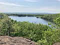
South Wassel Reservoir from Ragged Mountain summit
-
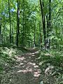
Preserve Trail
