
Anvik, Alaska facts for kids
Quick facts for kids
Anvik
Gitr'ingith Chagg
|
|
|---|---|
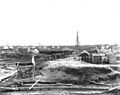
.jpeg)
Fish drying on racks in Anvik in 1901
|
|

Anvik
Location in Alaska
|
|
| Country | United States |
| State | Alaska |
| Census Area | Yukon-Koyukuk |
| Incorporated | October 6, 1969 |
| Area | |
| • Total | 11.93 sq mi (30.89 km2) |
| • Land | 9.49 sq mi (24.58 km2) |
| • Water | 2.44 sq mi (6.31 km2) |
| Elevation | 52 ft (16 m) |
| Population
(2020)
|
|
| • Total | 70 |
| • Density | 7.38/sq mi (2.85/km2) |
| Time zone | UTC-9 (Alaska (AKST)) |
| • Summer (DST) | UTC-8 (AKDT) |
| ZIP code |
99558
|
| Area code | 907 |
| FIPS code | 02-03880 |
Anvik is a small city in Alaska, United States. It is home to the Deg Hit'an people. The name Anvik means "exit" in the Central Alaskan Yup'ik language. Early Russian explorers might have given it this name. The local Deg Xinag name for Anvik is Deloy Ges. In 2010, about 85 people lived there. By 2020, the population was 70.
Contents
Exploring Anvik's Location
Anvik sits west of the Yukon River. It is right where the Anvik River flows into the Yukon. The city is about 34 miles (55 km) north of Holy Cross.
Getting Around Anvik
Anvik has its own public Anvik Airport. It has a gravel runway about 2,960 feet (902 meters) long. This airport is located about 1 mile (1.6 km) southeast of the city center.
Anvik's Connection to the Iditarod Trail
The Anvik Connector is a special trail. It links the community to the famous Iditarod Trail. This trail is about 86 miles (138 km) to the east. The Iditarod Trail is well-known for its dog sled race.
How Big is Anvik?
The United States Census Bureau says Anvik covers about 11.9 square miles (30.8 square kilometers). Most of this area, about 9.5 square miles (24.6 square kilometers), is land. The rest, about 2.4 square miles (6.2 square kilometers), is water.
Anvik's Population Over Time
Anvik first appeared in the U.S. Census in 1880. Back then, it was called Anvik Station and Village. There were 95 residents, mostly from the Tinneh tribe. The city officially became incorporated in 1969.
| Historical population | |||
|---|---|---|---|
| Census | Pop. | %± | |
| 1880 | 95 | — | |
| 1890 | 191 | 101.1% | |
| 1900 | 166 | −13.1% | |
| 1910 | 151 | −9.0% | |
| 1920 | 140 | −7.3% | |
| 1930 | 79 | −43.6% | |
| 1940 | 110 | 39.2% | |
| 1950 | 99 | −10.0% | |
| 1960 | 120 | 21.2% | |
| 1970 | 83 | −30.8% | |
| 1980 | 114 | 37.3% | |
| 1990 | 82 | −28.1% | |
| 2000 | 104 | 26.8% | |
| 2010 | 85 | −18.3% | |
| 2020 | 70 | −17.6% | |
| U.S. Decennial Census | |||
Who Lives in Anvik?
In 2000, 104 people lived in Anvik. Most residents, about 94%, were Native American. About 9% were White. The average household had about 2.67 people. The average family had about 3.43 people.
Age Groups in Anvik
In 2000, 34 people were under 15 years old. Nine people were between 18 and 24. Twenty-eight people were between 25 and 44. Eight people were 65 years or older. The average age in Anvik was about 30 years old.
Money and Living in Anvik
In 2000, the average household income was $21,250 per year. The average family income was $18,125. The income per person in the city was $8,081. About 44% of the population lived below the poverty line. This included 45.5% of those under 18.
Education in Anvik
The Iditarod Area School District manages the Blackwell School in Anvik. This school provides education for the children in the community.
Images for kids
-
Fish drying on racks in Anvik in 1901
See also
 In Spanish: Anvik (Alaska) para niños
