Sturbridge, Massachusetts facts for kids
Quick facts for kids
Sturbridge, Massachusetts
|
||
|---|---|---|

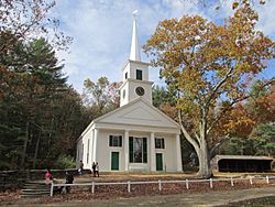
Center Meetinghouse
in Old Sturbridge Village |
||
|
||
| Motto(s):
"First New England Mining"
|
||

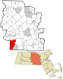
Location in Worcester County and the state of Massachusetts.
|
||
| Country | United States | |
| State | Massachusetts | |
| County | Worcester | |
| Settled | 1729 | |
| Incorporated | June 24, 1738 | |
| Government | ||
| • Type | Open town meeting | |
| Area | ||
| • Total | 39.0 sq mi (100.9 km2) | |
| • Land | 37.4 sq mi (96.9 km2) | |
| • Water | 1.5 sq mi (4.0 km2) | |
| Elevation | 619 ft (189 m) | |
| Population
(2020)
|
||
| • Total | 9,867 | |
| • Density | 253.0/sq mi (97.79/km2) | |
| Time zone | UTC-5 (Eastern) | |
| • Summer (DST) | UTC-4 (Eastern) | |
| ZIP code |
01566
|
|
| Area code(s) | 508 / 774 | |
| FIPS code | 25-68155 | |
| GNIS feature ID | 0618384 | |
| Website | www.sturbridge.gov | |
Sturbridge is a town located in Worcester County, Massachusetts, in the United States. It is well-known for Old Sturbridge Village, which is a living museum. This museum shows what life was like in the past. The town is also home to other interesting historical places like Tantiusques.
In 2020, the town had a population of 9,867 people. There were more than 3,600 homes in Sturbridge. You can find more details about specific parts of Sturbridge, like Fiskdale and Sturbridge (CDP).
Contents
History of Sturbridge
Sturbridge was first explored by English settlers called Puritans in 1644. A man named John Winthrop the Younger visited the area. This place is now known as Tantiusques.
Winthrop bought the land from a local leader named Tantasqua. He started mining for materials like graphite, lead, and iron. The mine stayed with the Winthrop family until 1784 and was used until 1910.
English settlers from Medfield first made their homes in Sturbridge in 1729. The town was officially recognized as a town in 1738. Before it was named Sturbridge, people thought about names like New Medfield or Dummer. The name Sturbridge comes from a town in England called Stourbridge.
Geography and Location
Sturbridge covers a total area of about 39.0 square miles (100.9 square kilometers). Most of this area, about 37.4 square miles (96.9 square kilometers), is land. The rest, about 1.5 square miles (4.0 square kilometers), is water.
Sturbridge is surrounded by other towns and states. To the east, it borders Charlton and Southbridge. To the south, it borders Union and Woodstock, Connecticut in Connecticut. To the west, you'll find Brimfield and Holland. To the north, it borders Brookfield and East Brookfield.
The town is about 29 miles (47 km) east of Springfield. It's also about 16 miles (26 km) southwest of Worcester. Boston, a major city, is about 55 miles (89 km) west of Sturbridge.
Major Roads and Highways
Several important roads run through Sturbridge. U.S. Route 20 goes right through the town. Sturbridge is also where Interstate 90 (known as the Massachusetts Turnpike) meets the start of Interstate 84.
Long ago, the Wilbur Cross Highway (Connecticut Route 15) used to end in Sturbridge. Some local people still call Haynes Street and parts of Mashapaug Road "Old Route 15". Haynes Street connects to Main Street (Massachusetts Route 131), which links Sturbridge Center to Southbridge. On the west side of town, Massachusetts Route 148 connects Fiskdale with Brookfield.
In 1955, a strong storm called Hurricane Diane caused a lot of rain and wind. This led to floods that broke dams in nearby towns and flooded parts of Sturbridge.
Sturbridge Neighborhoods
One part of Sturbridge, located in the northwest, is called Fiskdale. It's a special area that has its own post office and ZIP code.
Sturbridge Climate and Weather
| Climate data for Sturbridge (East Brimfield Lake), Massachusetts (1991–2020 normals, extremes 1962–present) | |||||||||||||
|---|---|---|---|---|---|---|---|---|---|---|---|---|---|
| Month | Jan | Feb | Mar | Apr | May | Jun | Jul | Aug | Sep | Oct | Nov | Dec | Year |
| Record high °F | 68 | 73 | 83 | 93 | 93 | 97 | 101 | 99 | 95 | 86 | 78 | 72 | 101 |
| Mean maximum °F | 56.8 | 55.6 | 64.9 | 79.1 | 86.1 | 89.1 | 91.0 | 89.1 | 85.5 | 77.4 | 68.7 | 59.1 | 93.2 |
| Mean daily maximum °F | 34.2 | 36.6 | 44.3 | 56.9 | 67.5 | 75.4 | 80.5 | 79.1 | 72.3 | 60.8 | 50.1 | 39.3 | 58.1 |
| Daily mean °F | 25.1 | 26.7 | 34.5 | 46.2 | 56.9 | 65.6 | 71.0 | 69.4 | 62.2 | 50.4 | 40.7 | 31.1 | 48.3 |
| Mean daily minimum °F | 16.1 | 16.9 | 24.7 | 35.5 | 46.2 | 55.9 | 61.5 | 59.7 | 52.2 | 39.9 | 31.3 | 22.9 | 38.6 |
| Mean minimum °F | −4.2 | −2.5 | 6.2 | 23.9 | 32.2 | 41.7 | 51.1 | 48.1 | 36.9 | 26.6 | 16.0 | 5.0 | −7.1 |
| Record low °F | −27 | −24 | −16 | 5 | 26 | 32 | 42 | 33 | 26 | 15 | −1 | −14 | −27 |
| Average precipitation inches | 3.67 | 3.19 | 4.26 | 4.32 | 3.48 | 3.86 | 4.04 | 4.41 | 4.07 | 4.85 | 3.91 | 4.56 | 48.62 |
| Average snowfall inches | 13.4 | 16.8 | 13.6 | 3.8 | 0.0 | 0.0 | 0.0 | 0.0 | 0.0 | 0.1 | 2.0 | 13.8 | 63.5 |
| Average extreme snow depth inches | 10.1 | 11.6 | 10.5 | 2.3 | 0.0 | 0.0 | 0.0 | 0.0 | 0.0 | 0.0 | 1.9 | 8.6 | 16.8 |
| Record high °C | 20 | 23 | 28 | 34 | 34 | 36 | 38 | 37 | 35 | 30 | 26 | 22 | 38 |
| Mean daily maximum °C | 1.2 | 2.6 | 6.8 | 13.8 | 19.7 | 24.1 | 26.9 | 26.2 | 22.4 | 16.0 | 10.1 | 4.1 | 14.5 |
| Daily mean °C | −3.8 | −2.9 | 1.4 | 7.9 | 13.8 | 18.7 | 21.7 | 20.8 | 16.8 | 10.2 | 4.8 | −0.5 | 9.1 |
| Mean daily minimum °C | −8.8 | −8.4 | −4.1 | 1.9 | 7.9 | 13.3 | 16.4 | 15.4 | 11.2 | 4.4 | −0.4 | −5.1 | 3.7 |
| Record low °C | −33 | −31 | −27 | −15 | −3 | 0 | 6 | 1 | −3 | −9 | −18 | −26 | −33 |
| Average precipitation mm | 93 | 81 | 108 | 110 | 88 | 98 | 103 | 112 | 103 | 123 | 99 | 116 | 1,234 |
| Average snowfall cm | 34 | 43 | 35 | 9.7 | 0.0 | 0.0 | 0.0 | 0.0 | 0.0 | 0.25 | 5.1 | 35 | 162.05 |
| Average extreme snow depth cm | 26 | 29 | 27 | 5.8 | 0.0 | 0.0 | 0.0 | 0.0 | 0.0 | 0.0 | 4.8 | 22 | 43 |
| Average precipitation days (≥ 0.01 in) | 12.8 | 10.8 | 11.6 | 12.4 | 13.7 | 11.2 | 10.9 | 11.7 | 9.9 | 11.2 | 10.5 | 12.4 | 139.1 |
| Average snowy days (≥ 0.1 in) | 6.7 | 6.2 | 4.6 | 1.2 | 0.0 | 0.0 | 0.0 | 0.0 | 0.0 | 0.2 | 1.3 | 4.7 | 24.9 |
| Source 1: NOAA | |||||||||||||
| Source 2: National Weather Service | |||||||||||||
Population and People
| Historical population | ||
|---|---|---|
| Year | Pop. | ±% |
| 1850 | 2,119 | — |
| 1860 | 2,291 | +8.1% |
| 1870 | 2,101 | −8.3% |
| 1880 | 2,062 | −1.9% |
| 1890 | 2,074 | +0.6% |
| 1900 | 2,058 | −0.8% |
| 1910 | 1,957 | −4.9% |
| 1920 | 1,573 | −19.6% |
| 1930 | 1,772 | +12.7% |
| 1940 | 2,227 | +25.7% |
| 1950 | 2,805 | +26.0% |
| 1960 | 3,604 | +28.5% |
| 1970 | 4,878 | +35.3% |
| 1980 | 5,976 | +22.5% |
| 1990 | 7,775 | +30.1% |
| 2000 | 7,837 | +0.8% |
| 2010 | 9,268 | +18.3% |
| 2020 | 9,867 | +6.5% |
| 2022 | 9,882 | +0.2% |
Source: United States Census records and Population Estimates Program data. |
||
In 2010, the population of Sturbridge was 9,268 people. By the 2020 census, it had grown to 9,867 people.
Back in 2000, there were 7,837 people living in Sturbridge. There were 3,066 households, which means groups of people living together. Out of these, 2,213 were families.
About 34.2% of households had children under 18 living with them. Many households, 60.7%, were married couples. The average household had about 2.55 people. The average family had about 3.03 people.
The median age in town was 39 years old. This means half the people were younger than 39 and half were older.
Arts and Culture in Sturbridge
Interesting Places to Visit
- Old Sturbridge Village: This is a special living museum located on U.S. Route 20. It shows what life was like in rural New England between the 1790s and the 1830s. You can see old buildings and people dressed in historical clothes.
- Tantiusques: This is an open-space area and a historic site. It's a great place to explore nature and learn about the past.
- Wells State Park: This park covers 1,400 acres (about 567 hectares) of woodland. It's located on Route 49. The park has 10 miles (16 km) of trails for hiking. It also has Walker Pond, where you can go fishing, canoeing, or swimming.
Sturbridge is also home to the Sturbridge Worship Center church. This church has an impact on the wider New England area.
Education in Sturbridge
Sturbridge has public schools for its students.
- Burgess Elementary School: This school serves students from kindergarten to 6th grade. It has its own school committee.
- Tantasqua Regional Junior High School: Students in grades 7 and 8 attend this school.
- Tantasqua Regional High School: High school students attend this school, which is in the Fiskdale part of town.
The schools in Sturbridge share administrators, including the superintendent, with other nearby towns. These towns include Brimfield, Brookfield, Holland, and Wales.
Sturbridge Public Library
The Sturbridge Public Library was first opened in 1873. It provides books and resources for the community. In 2008, the town spent about $332,136 on its public library. This was about $36 per person each year.
Notable Person from Sturbridge
- Katharine Johnson Jackson (1841–1921): She was a physician, which means she was a doctor.
See also
 In Spanish: Sturbridge (Massachusetts) para niños
 | James Van Der Zee |
 | Alma Thomas |
 | Ellis Wilson |
 | Margaret Taylor-Burroughs |


