Charlton, Massachusetts facts for kids
Quick facts for kids
Charlton, Massachusetts
|
|||
|---|---|---|---|

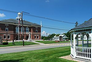
Charlton Center
|
|||
|
|||

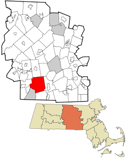
Location in Worcester County and the state of Massachusetts.
|
|||
| Country | United States | ||
| State | Massachusetts | ||
| County | Worcester | ||
| Settled | 1735 | ||
| Incorporated | 1775 | ||
| Government | |||
| • Type | Open town meeting | ||
| Area | |||
| • Total | 43.8 sq mi (113.4 km2) | ||
| • Land | 42.5 sq mi (110.2 km2) | ||
| • Water | 1.3 sq mi (3.2 km2) | ||
| Elevation | 895 ft (273 m) | ||
| Population
(2020)
|
|||
| • Total | 13,315 | ||
| • Density | 304.0/sq mi (117.42/km2) | ||
| Time zone | UTC−5 (Eastern) | ||
| • Summer (DST) | UTC−4 (Eastern) | ||
| ZIP Code |
01507–01509
|
||
| Area code(s) | 508 / 774 | ||
| FIPS code | 25-12715 | ||
| GNIS feature ID | 0618359 | ||
| Website | www.townofcharlton.net | ||
Charlton is a town located in Worcester County, Massachusetts, in the United States. In 2020, about 13,315 people lived here.
Contents
History of Charlton
Charlton was first settled way back in 1735. It started as a special "District" that separated from the town of Oxford on January 10, 1755. Later, in 1775, it officially became a full "Town."
The town was named after Sir Francis Charlton. For many years, farming was the main job for people living in Charlton. By the early 1900s, woolen mills began to be built along the town's brooks, changing how people worked.
Geography and Location
Charlton covers a total area of about 43.8 square miles (113.4 square kilometers). Most of this area, about 42.5 square miles (110.2 square kilometers), is land. The rest, about 1.2 square miles (3.2 square kilometers), is water.
Where is Charlton located?
The town is surrounded by several other towns. To the west, you'll find Sturbridge. To the north are East Brookfield, Spencer, and Leicester. On the east side is Oxford, and to the south are Dudley and Southbridge.
Roads and Transportation
Charlton has important roads that run through it. Route 31 goes from north to south, passing through historic areas like Charlton Center, Charlton City, and Charlton Depot. Another north-south road, Route 169, connects Charlton City to Southbridge.
Major east-west roads include Route 20, which is a busy road for commuters. The Massachusetts Turnpike (also known as Interstate 90) also crosses through Charlton. While there isn't an exit directly into Charlton from the Turnpike, there are two rest stops located within the town.
Population and People
Charlton has grown quite a bit over the years. In 1850, there were just over 2,000 people living here. By 2020, the population had grown to 13,315.
| Historical population | ||
|---|---|---|
| Year | Pop. | ±% |
| 1850 | 2,015 | — |
| 1860 | 2,047 | +1.6% |
| 1870 | 1,878 | −8.3% |
| 1880 | 1,900 | +1.2% |
| 1890 | 1,847 | −2.8% |
| 1900 | 1,860 | +0.7% |
| 1910 | 2,032 | +9.2% |
| 1920 | 1,995 | −1.8% |
| 1930 | 2,154 | +8.0% |
| 1940 | 2,557 | +18.7% |
| 1950 | 3,136 | +22.6% |
| 1960 | 3,685 | +17.5% |
| 1970 | 4,654 | +26.3% |
| 1980 | 6,719 | +44.4% |
| 1990 | 9,576 | +42.5% |
| 2000 | 11,263 | +17.6% |
| 2010 | 12,981 | +15.3% |
| 2020 | 13,315 | +2.6% |
| 2022* | 13,360 | +0.3% |
| * = population estimate. Source: United States Census records and Population Estimates Program data. |
||
In 2000, about 30% of the people in Charlton were under 18 years old. The average age in town was 35 years. Many families live in Charlton, with about 45% of households having children under 18.
Education in Charlton
Charlton's public schools are part of the Dudley–Charlton Regional School district. This means students from both Charlton and Dudley attend schools in the same system.
What schools are in Charlton?
- Charlton Elementary School teaches students in kindergarten and first grade.
- The Heritage School is for students in grades 2 through 4.
- Charlton Middle School serves students from grades 5 through 8.
- For high school, students from Charlton (grades 9 through 12) attend Shepherd Hill Regional High School in Dudley.
Charlton is also home to Bay Path Regional Vocational Technical High School. This school offers special training in different trades and skills. It serves students from Charlton and nearby towns.
Did you know there used to be a Charlton High School right in the center of town? That building is now used for the Charlton Municipal Offices, where town business is handled.
Places and People of Interest
Charlton has several interesting places and connections to famous people.
- Grave of John "Grizzly" Adams: This is the burial place of a famous mountain man and animal trainer.
- John Spurr House: An historic house in town.
- Rider Tavern: Another historic building.
- Charlton Center Historic District: An area with many old and important buildings.
- Northside Village Historic District: Another historic area.
- No. 2 Schoolhouse: An old school building.
- Nature's Classroom Headquarters: A place that helps kids learn about nature.
- Heritage Country Club: A local golf course.
- Buffumville Lake: A popular spot for outdoor activities.
- Elliott P. Joslin Camps for Children with Diabetes: A special camp for kids with diabetes.
- Bay Path Regional Vocational Technical High School: A vocational school.
- Tree House Brewing Company: A well-known local brewery.
- William T. G. Morton: The residence of the person who first showed how ether could be used to make surgery painless.
- Charlton Woolen Mill: In 2012, part of this historic mill was damaged by a large fire.
Images for kids
See also
In Spanish: Charlton (Massachusetts) para niños
 | Selma Burke |
 | Pauline Powell Burns |
 | Frederick J. Brown |
 | Robert Blackburn |


