Southbridge, Massachusetts facts for kids
Quick facts for kids
Southbridge, Massachusetts
|
|||
|---|---|---|---|
|
Town
|
|||
| Town of Southbridge[*] | |||

|
|||
|
|||
| Nickname(s):
The Eye of the Commonwealth
|
|||

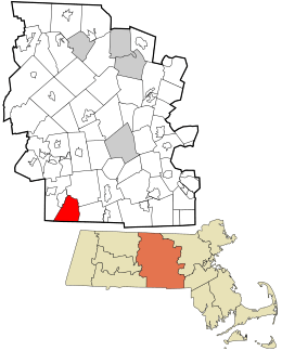
Location in Worcester County and the state of Massachusetts
|
|||
| Country | United States | ||
| State | Massachusetts | ||
| County | Worcester | ||
| Settled | 1730 | ||
| Incorporated | 1816 | ||
| Government | |||
| • Type | Council-manager | ||
| Area | |||
| • Total | 20.86 sq mi (54.03 km2) | ||
| • Land | 20.24 sq mi (52.42 km2) | ||
| • Water | 0.62 sq mi (1.61 km2) | ||
| Elevation | 489 ft (149 m) | ||
| Population
(2020)
|
|||
| • Total | 17,740 | ||
| • Density | 876.57/sq mi (338.44/km2) | ||
| Time zone | UTC-5 (Eastern) | ||
| • Summer (DST) | UTC-4 (Eastern) | ||
| ZIP code |
01550
|
||
| Area code(s) | 508 / 774 | ||
| FIPS code | 25-63270 | ||
| GNIS feature ID | 0618383 | ||
Southbridge is a town located in Worcester County, Massachusetts, United States. In 2020, about 17,740 people lived there. Even though Southbridge has a city-like government, it is officially known as the Town of Southbridge.
Contents
History of Southbridge
The area where Southbridge is now was first home to the Nipmuck and Mohegan Native American tribes. The Quinebaug River separated their lands. In 1638, John Winthrop Jr. bought land called Tantiusques. He hoped to find lead there, but it was actually graphite. The Winthrops used Nipmuck miners to get this graphite.
European settlers first came to Southbridge in 1730. In 1801, a new religious group called the Second Religious Society of Charlton was formed. People often called it "Honest Town." This group was made up of parts of Dudley, Charlton, and Sturbridge. In 1816, this area officially became the town of Southbridge.
Early settlers included Moses Marcy and the Dennison family. The Quinebaug River provided water power, which was great for sawmills and gristmills in the 1700s. Later, in the 1800s, it helped power textile mills. After the American Civil War, many people from Ireland and French Canadian families moved to Southbridge for work. By the 1930s, people from Poland, Greece, Italy, and other countries also came to live there.
The "Eye of the Commonwealth"
Southbridge is famous for making optical products. This is why it's sometimes called the "Eye of the Commonwealth." The American Optical Company ("AO") was a very important business here. It became the world's largest maker of eye care products. At its busiest, AO employed over 6,000 people around the world.
During World War II, many AO workers did important defense work. They made parts for Norden bombsights and even helped with some work related to the atomic bomb. Because their work was so important, many workers did not have to join the military.
By the early 1960s, Southbridge had a movie theater, a radio station (WESO), and an airport. In the 1970s and 1980s, new immigrants from Puerto Rico, Laos, and Vietnam arrived. Today, Southbridge has a large Hispanic and Puerto Rican population. The American Optical Company closed in 1984. Southbridge has been working to recover from the loss of these and other factory jobs.
Geography
Southbridge covers about 20.9 square miles (54.03 km²). Most of this area is land (20.4 sq mi or 52.42 km²), and a smaller part is water (0.5 sq mi or 1.61 km²). The Quinebaug River flows through Southbridge.
The main road in Southbridge is Massachusetts Route 131. It is known as Main Street in the downtown area. Other important roads include Eastford Road, Elm Street (Massachusetts Route 198), and Worcester Street-Mechanic Street-North Woodstock Road (Massachusetts Route 169).
Southbridge was created from parts of three nearby towns: Sturbridge to the west, Charlton to the north, and Dudley to the east. To the south, Southbridge borders Woodstock, Connecticut.
Population Data
| Historical population | ||
|---|---|---|
| Year | Pop. | ±% |
| 1850 | 2,824 | — |
| 1860 | 3,575 | +26.6% |
| 1870 | 5,208 | +45.7% |
| 1880 | 6,464 | +24.1% |
| 1890 | 7,655 | +18.4% |
| 1900 | 10,025 | +31.0% |
| 1910 | 12,592 | +25.6% |
| 1920 | 14,245 | +13.1% |
| 1930 | 14,264 | +0.1% |
| 1940 | 16,825 | +18.0% |
| 1950 | 17,519 | +4.1% |
| 1960 | 16,523 | −5.7% |
| 1970 | 17,057 | +3.2% |
| 1980 | 16,665 | −2.3% |
| 1990 | 17,816 | +6.9% |
| 2000 | 17,214 | −3.4% |
| 2010 | 16,719 | −2.9% |
| 2020 | 17,740 | +6.1% |
| 2023* | 17,880 | +0.8% |
| * = population estimate. Source: United States Census records and Population Estimates Program data. Source: |
||
In 2010, Southbridge had 16,719 people living there. There were 7,077 households and 4,522 families. The population density was about 858.9 people per square mile.
About 81.2% of the people were White, 2.6% were Black or African American, and 0.5% were Native American. About 1.9% were Asian. People of Hispanic or Latino background made up 26.6% of the population.
About 31.1% of households had children under 18 living with them. The average household had 2.41 people. The average family had 2.98 people.
The population was spread out by age. About 25.4% were under 18. About 15.1% were 65 or older. The average age was 36 years.
Library
The Southbridge Public Library opened in 1870. It is now called the Jacob Edwards Library. It is a public library for the town of Southbridge. The library is part of the Central Massachusetts Regional Library System (CMRLS) and C/W MARS.
Education
Southbridge has public schools for all ages. There are elementary schools, a middle school, and a high school.
- Eastford Road School teaches Pre-Kindergarten to 1st grade.
- Charlton Street School teaches grades 2 to 5.
- West Street School is a Dual Language School.
- Grades 6 to 12 attend Southbridge Middle School and Southbridge High School.
Students in Southbridge can also choose to go to Bay Path Regional Vocational Technical High School in Charlton. This school teaches job skills.
There is also a private Catholic school called Trinity Catholic Academy. It teaches students from Pre-Kindergarten through eighth grade.
In 2016, the Massachusetts Board of Elementary and Secondary Education decided to help improve the Southbridge School District. This is called "state receivership."
Transportation
Southbridge has its own airport, called Southbridge Municipal Airport (3B0). It is owned by the public. The airport has one runway that is 3,501 feet long and 75 feet wide.
Places to Visit
- The Quinebaug Valley Council for the Arts and Humanities – Arts Center
- Gateway Players Theatre
- New York, New Haven & Hartford Passenger Depot
- Southbridge Hotel and Conference Center
- Westville Lake and Recreation Area, an outdoor area along the Quinebaug River
- The Optical Heritage Museum
Notable People
- Geraldo Alicea, politician
- George Thorndike Angell, lawyer
- Jeff Belanger, author
- Don Berry, statistician
- Franklin E. Brooks, politician
- Mark Carron, politician
- Sidney Clarke, politician
- George Constantine, racing driver
- Jane Cunningham Croly, author
- Joel DiGregorio, keyboardist for the Charlie Daniels Band
- Kenny Dykstra, wrestler
- Michael Earls, Jesuit priest
- John Fitzgerald, football player
- Félix Gatineau, historian and politician
- Francis Harper, biologist
- William L. Marcy, politician and Governor of New York
- Leo Martello, priest
- Ann McNamee, musician
- Tim Moriarty, journalist
- Calvin Paige, businessman and politician
- Winthrop D. Putnam, soldier
- Barbara Stevens, college basketball coach
- Charles Burt Sumner, minister
- Bill Swiacki, football player
- Marilyn Travinski, politician
- William Tremblay, poet, novelist, and professor
- Mfoniso Udofia, writer
- Cady Wells, painter
- David Wu, actor
See also
 In Spanish: Southbridge (Massachusetts) para niños
 | George Robert Carruthers |
 | Patricia Bath |
 | Jan Ernst Matzeliger |
 | Alexander Miles |


