
Danielson, Connecticut facts for kids
Quick facts for kids
Danielson, Connecticut
|
|
|---|---|
| Borough of Danielson | |

Looking down Main St.
|
|
 Windham County and Connecticut Windham County and Connecticut Northeastern Connecticut Planning Region and Connecticut Northeastern Connecticut Planning Region and Connecticut |
|
| Country | |
| U.S. state | |
| County | Windham |
| Region | Northeastern CT |
| Town | Killingly |
| Area | |
| • Total | 1.16 sq mi (3.00 km2) |
| • Land | 1.09 sq mi (2.83 km2) |
| • Water | 0.07 sq mi (0.17 km2) |
| Elevation | 223 ft (68 m) |
| Population
(2020)
|
|
| • Total | 4,155 |
| • Density | 3,800/sq mi (1,470/km2) |
| Time zone | UTC−5 (Eastern (EST)) |
| • Summer (DST) | UTC−4 (EDT) |
| ZIP Code |
06239
|
| Area code(s) | 860 |
| FIPS code | 09-18780 |
| GNIS feature ID | 0206590 |
Danielson is a small town, or "borough," located in Killingly, Connecticut. It's part of Windham County in the United States. In 2020, about 4,155 people lived there.
Contents
History of Danielson

Danielson has an interesting past! It was first called "Danielsonville." This name came from General James Danielson. He built the very first house in this area. Later, in 1895, the name was shortened to just Danielson.
Historic Places in Danielson
Danielson has special areas called historic districts. These places are protected because they have old and important buildings. Two of these districts are listed on the National Register of Historic Places:
- The Danielson Main Street Historic District is about 20 acres (8 hectares) big. It runs along Main Street. You can see buildings with styles like Colonial Revival and Italianate here. This district was added to the National Register of Historic Places in 1992.
- The Broad Street – Davis Park Historic District is located near Broad Street. It has buildings in styles like Stick/Eastlake, Queen Anne, and Colonial Revival. This district was added to the National Register of Historic Places in 1998.
Danielson is also home to the Temple Beth Israel synagogue. This building was added to the National Register of Historic Places in 2003.
Geography of Danielson
Danielson is a small area. It covers about 1.2 square miles (3.0 square kilometers). Most of this area is land, about 1.1 square miles (2.8 square kilometers). The rest, about 0.1 square miles (0.26 square kilometers), is water.
People of Danielson
| Historical population | |||
|---|---|---|---|
| Census | Pop. | %± | |
| 1900 | 2,823 | — | |
| 1910 | 2,934 | 3.9% | |
| 1920 | 3,130 | 6.7% | |
| 1930 | 4,210 | 34.5% | |
| 1940 | 4,507 | 7.1% | |
| 1950 | 4,554 | 1.0% | |
| 1960 | 4,642 | 1.9% | |
| 1970 | 4,580 | −1.3% | |
| 1980 | 4,553 | −0.6% | |
| 1990 | 4,441 | −2.5% | |
| 2000 | 4,265 | −4.0% | |
| 2010 | 4,051 | −5.0% | |
| 2020 | 4,155 | 2.6% | |
| U.S. Decennial Census | |||
In 2010, about 4,051 people lived in Danielson. There were 1,627 households, which are groups of people living together. The population density was about 3,683 people per square mile (1,422 people per square kilometer).
Most people in Danielson are White (88.7%). Other groups include African American (2.8%), Asian (2.9%), and Native American (0.5%). About 5.7% of the population identified as Hispanic or Latino.
Danielson and the town of Killingly have a small community of people from Laos. These towns are among the top 50 cities in the U.S. with the most people of Laotian background. The first Laotian family came to Danielson in 1979. A local couple helped nearly 500 Laotian refugees settle here over the next ten years.
Age and Income in Danielson
The average age of people in Danielson is 35 years old. About 24% of the population is under 18. About 10% are 65 years or older.
The average income for a household in Danielson was about $58,933. For families, it was about $62,803. About 14.1% of all people, and 21.1% of those under 18, lived below the poverty line.
Transportation in Danielson
Danielson has its own airport, called Danielson Airport. It's a public airport located a short distance northwest of the town center.
Major roads run through Danielson. Interstate 395 (I-395) goes north and south. U.S. Route 6 (US 6) goes east and west. Route 12 also runs through the downtown area.
Notable People from Danielson
Many interesting people have connections to Danielson:
- Ida Bailey Allen (1885-1973): A famous American chef and cookbook author. She was known as "The Nation's Homemaker."
- Frank Dascoli (1913–1990): A professional baseball umpire in the National League.
- Sarah Katherine Taylor (1847–1920): An American evangelist and temperance activist. She also worked as a newspaper editor.
- Charles Lewis Tiffany (1812–1902): A leader in the jewelry business. He founded Tiffany & Co. in New York City in 1837.
Images for kids
-
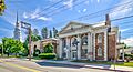
Looking down Main Street in Danielson.
-
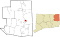
Danielson's location within Windham County, Connecticut.
-
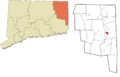
Danielson's location within the Northeastern Connecticut Planning Region.
See also
 In Spanish: Danielson (Connecticut) para niños
