Plainfield, Connecticut facts for kids
Quick facts for kids
Plainfield, Connecticut
|
||
|---|---|---|
| Town of Plainfield | ||

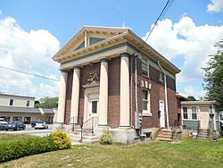
Former bike shop that was repurposed to a barbershop in Plainfield Village
|
||
|
||
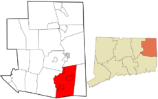
 Windham County and Connecticut Windham County and Connecticut Northeastern Connecticut Planning Region and Connecticut
|
||
| Country | ||
| U.S. state | ||
| County | Windham | |
| Region | Northeastern CT | |
| Incorporated | 1699 | |
| Government | ||
| • Type | Selectman-town meeting | |
| Area | ||
| • Total | 43.0 sq mi (111.4 km2) | |
| • Land | 42.3 sq mi (109.5 km2) | |
| • Water | 0.8 sq mi (2.0 km2) | |
| Elevation | 400 ft (122 m) | |
| Population
(2020)
|
||
| • Total | 14,973 | |
| • Density | 354/sq mi (136.7/km2) | |
| Time zone | UTC-5 (Eastern) | |
| • Summer (DST) | UTC-4 (Eastern) | |
| ZIP code |
06354, 06374
|
|
| Area code(s) | 860/959 | |
| FIPS code | 09-59980 | |
| GNIS feature ID | 0213487 | |
Plainfield is a town in Windham County, Connecticut, United States. It is part of the Northeastern Connecticut Planning Region. In 2020, about 14,973 people lived here.
Plainfield includes four smaller areas called villages. These are Plainfield (south), Moosup (northeast), Wauregan (northwest), and Central Village (west). Each village has its own Post Office and fire department. The whole town uses the 860 area code for phone calls.
Contents
History of Plainfield
Plainfield became a town in 1699. It was first called Quinebaug, but its name changed the next year to Plainfield. The name "Plainfield" describes the flat land where the town first started.
In the 1800s and early 1900s, Plainfield was an important industrial town. This was because the Moosup and Quinebaug Rivers provided power for many mills. These jobs brought people from different countries, like French Canadian Americans, Irish Americans, and British Americans, to live in Plainfield.
Besides the mills, Plainfield was a busy place for trade. Four different railway lines from Hartford, New York, Boston, and Providence met in the town. There was also a well-known school on Academy Hill, which is how the road there got its name. Plainfield also holds the oldest V-J Day parade in the United States every year.
Some places in Plainfield are listed on the National Register of Historic Places. These are:
- Central Village Historic District, a special area with old buildings
- March Route of Rochambeau's Army: Old Canterbury Road
Plainfield's Geography
Plainfield is located at 41.6775 degrees North and 71.9220 degrees West.
The town covers about 43 square miles (110 km2) of land and water. Most of this, about 42.3 square miles (110 km2), is land. The rest, about 0.8 square miles (2.1 km2), is water. Plainfield is about 20 miles (32 km) from the Atlantic Ocean. It is the southernmost town in Windham County. The Quinebaug River forms most of the town's western edge. The Moosup River flows into the Quinebaug and crosses the northern part of Plainfield.
Getting Around Plainfield
The Connecticut Turnpike (I-395 and CT 695) goes right through Plainfield. There are three exits from I-395 that lead into Plainfield: Exit 28 (Lathrop Road), Exit 29 (CT 14A), and Exit 32 (CT 14). These exits are all on the I-395 part of the highway, which runs north and south. Another road, CT 12, runs mostly next to the Turnpike on its west side.
There are no airports, passenger trains, or major waterways for boats in Plainfield. However, a freight train line, the Providence and Worcester Railroad, runs through the town. Public transportation is limited, and there are not many sidewalks or bike paths. This means most people travel by car in Plainfield.
Plainfield is close to several major cities:
- Providence, Rhode Island, is about 30 miles (48 km) to the east.
- Hartford, Connecticut, is about 40 miles (64 km) to the west.
- Boston, Massachusetts, is about 60 miles (97 km) to the northeast.
- New York City (Manhattan) is about 120 miles (190 km) to the southwest.
The closest international airport is T. F. Green Airport (PVD) in Warwick, Rhode Island. You can find Amtrak passenger train stations in New London and Providence, both about a 40-minute drive away.
Plainfield's Population
| Historical population | |||
|---|---|---|---|
| Census | Pop. | %± | |
| 1820 | 2,097 | — | |
| 1840 | 2,383 | — | |
| 1850 | 2,732 | 14.6% | |
| 1860 | 3,665 | 34.2% | |
| 1870 | 4,521 | 23.4% | |
| 1880 | 4,021 | −11.1% | |
| 1890 | 4,582 | 14.0% | |
| 1900 | 4,821 | 5.2% | |
| 1910 | 6,719 | 39.4% | |
| 1920 | 7,926 | 18.0% | |
| 1930 | 8,027 | 1.3% | |
| 1940 | 7,613 | −5.2% | |
| 1950 | 8,071 | 6.0% | |
| 1960 | 8,884 | 10.1% | |
| 1970 | 11,957 | 34.6% | |
| 1980 | 12,774 | 6.8% | |
| 1990 | 14,363 | 12.4% | |
| 2000 | 14,619 | 1.8% | |
| 2010 | 15,405 | 5.4% | |
| 2020 | 14,973 | −2.8% | |
| U.S. Decennial Census | |||
In 2000, there were 14,619 people living in Plainfield. The town had 5,444 households and 3,908 families. The average household had about 2.65 people.
About 26.9% of the people in Plainfield were under 18 years old. The median age was 35 years. This means half the population was younger than 35, and half was older.
Education in Plainfield
The Plainfield Board of Education, also known as Plainfield Public Schools, manages the schools in town. There are five schools in Plainfield.
Elementary Schools (Grades K–5)
- Moosup Elementary School (Kindergarten to 3rd grade)
- Plainfield Memorial School (4th to 5th grade)
- Shepard Hill Elementary School (Pre-Kindergarten to 3rd grade)
Middle School (Grades 6–8)
- Plainfield Central Middle School
High School (Grades 9–12)
- Plainfield High School
See also
 In Spanish: Plainfield (Connecticut) para niños
 | Percy Lavon Julian |
 | Katherine Johnson |
 | George Washington Carver |
 | Annie Easley |


