
Wauregan, Connecticut facts for kids
Quick facts for kids |
|
|
Wauregan Historic District
|
|
 |
|

Location in Windham County and the state of Connecticut.
|
|
| Location | Roughly bounded by CT 12, CT 205, Third St., Quinebaug River, and Chestnut St., Plainfield, Connecticut |
|---|---|
| Area | 90 acres (36 ha) |
| Architectural style | Greek Revival, Late Victorian |
| NRHP reference No. | 79003789 |
| Added to NRHP | August 24, 1979 |
Wauregan is a small village in Plainfield, Connecticut. It started as a mill village, built around a cotton mill that used the power of the Quinebaug River. Wauregan and West Wauregan (which is across the river in Brooklyn) together form a larger area called a census-designated place. In 2010, about 1,205 people lived there.
A special part of Wauregan is known as the Wauregan Historic District. This area covers about 90-acre (360,000 m2) and includes buildings that show what life was like when the mill was active. This district was added to the National Register of Historic Places in 1979 because of its important history. You can still see buildings like the old Wauregan Mill, homes for workers, boarding houses, and the company store. The buildings show styles like Greek Revival and Late Victorian architecture.
Contents
What is the History of Wauregan?
The name Wauregan comes from a Mohegan word meaning "Pleasant Valley." This village has a long history as a place where factories operated.
How Did the Wauregan Mill Start?
In 1850, a man named Amos D. Lockwood bought the land and water rights in Wauregan. He was already involved with another mill nearby. The Wauregan Mills Company was officially approved in 1853, and the first mill building was constructed around 1853-1854. This mill became famous for its woven cotton fabrics, especially different kinds of flannel.
Lockwood was the first manager, and he hired James S. Atwood to be the superintendent. Atwood was in charge of setting up all the machines and starting production. The main product made at Wauregan was cotton sheeting, a type of fabric.
How Did James S. Atwood Improve the Village?
In 1858, James S. Atwood bought the mill from Lockwood. He cared a lot about the village around the mill. He wanted to create a "model hamlet" where his workers could have "attractive and comfortable homes" close to their jobs.
Under Atwood's leadership, Wauregan grew and became successful.
- The mill was made bigger.
- More houses were built for workers.
- New services were added to the village.
The company owned 104 buildings with 255 apartments for workers to rent. There were also two boarding houses for workers who were not married. A railroad station was built in 1859, and a post office opened in 1860. In 1875, a company store was built, which sold goods to workers at lower prices. Another building in the village had a firehouse, a clubhouse, a small jail, and a reading room with a library. The mill even had its own dairy farm and woodlands.
Atwood made the factory four times larger. He added the south part of the front mill in 1859 and the entire back section in 1867-68. About 750 people worked at the mill, and most of them lived in the village. The mill eventually had many machines, producing about eleven million yards of fabric each year.
How Did the Atwood Sons Continue the Business?
After James S. Atwood passed away, his twin sons, James Arthur and John Walter Atwood, took over the Wauregan Mills. They continued to expand and improve the mill. By 1917, the mill employed 325 men and 160 women and children.
The Atwood brothers were smart about dealing with new competition from steam-powered mills. Instead of just making cotton sheeting, they started producing finer quality cotton goods, like fabric for the U.S. Marine Corps. They also began making rayon, which is a synthetic fabric. Wauregan Mills worked closely with DuPont and was one of the first to develop synthetic fabrics. This partnership helped them create fabric blends, like wool and rayon.
Unlike many other large mills that only made one type of product, Wauregan Mills could easily change what they produced. This helped them stay profitable through World War II, much longer than many other mills.
Why Did Wauregan Mills Close?
After World War II, Wauregan Mills faced tough times. In the 1950s, new trade policies meant that cheap cotton goods from Japan flooded the U.S. market. Japan had modern equipment, which made their production very cheap. This caused many textile mills in New England to close.
Wauregan Mills tried to focus on synthetic blends and reduce costs. However, in August 1955, two big storms, Hurricane Connie and Hurricane Diane, caused many dams on the Quinebaug River to break. The Wauregan mill was flooded up to the first floor ceilings. Workers tried to save materials and machines, but the company lost over $1,500,000.
The company borrowed money to restart production, but they didn't have enough funds to repair and update their facilities. In 1957, James Arthur Atwood III, the grandson of James S. Atwood, and the company directors decided to close all operations.
James Arthur Atwood III was in charge of selling the company's property to pay off its debts. Land, the water company, and other properties were sold. The mill building was rented out to different businesses. American Standard was one of the first companies to buy land and build a factory in Wauregan after the mill closed. All of Wauregan Mill's debts were finally paid off by 1970.
In 1974, a company called C&M Corporation owned and used the former Wauregan Mills complex. They made electrical cable there and had their main office in the building. In 2014, the Wauregan Mill was sold to a real estate company.
Today, the village still looks much like it did in the 1850s. The Wauregan Historic District was officially recognized in 1979.
Where is Wauregan Located?
The village is built around the old mill site on the east side of the Quinebaug River. This is near where modern Route 205 crosses the river. The village stretches eastward from the river, going up a gentle hill towards Route 12.
The houses for the mill workers are on Walnut and Chestnut streets, just east of the mill. The houses for supervisors and the company store are further east and higher up the hill. The mill owners' houses and the church are even further up and east.
The historic district covers about 90 acres (360,000 m2). It is generally bordered by Grove Street, Fountain Street, Route 12, Route 205, and South Chestnut Street on the east. On the south, it's bordered by Third Street. On the west, it's bordered by South Walnut Street, an extension of First Street, and the Quinebaug River. To the north, it's bordered by the extension of North Chestnut Street. This historic area includes 114 buildings and structures.
The Wauregan area, as defined by the United States Census Bureau, covers about 1.7 square miles (4.3 km2). Most of this is land, with a small amount of water. This larger area includes West Wauregan (across the river in Brooklyn), open land to the north, newer homes to the south, and modern businesses along Route 12.
What are the Notable Buildings in Wauregan?
Here are some important buildings you can find in the Wauregan Historic District:
- Wauregan Mills: This is the main mill building. It's shaped like an "H." The first part was built in 1853. It has four stories and a tall tower. More sections were added later, including a rear mill in 1867-68. The two main buildings are connected over the power canal. The mill is currently empty and was listed for sale in 2023.
- Company Store: This building was built in 1875. It used to be where workers could buy food and other goods from the company. It combines Italianate and Greek Revival styles. Today, it's used by the Connecticut Mop Manufacturing Company.
- Former Congregational Church: The Wauregan Congregational Church was built in 1873 in the High Victorian Gothic style. It had wooden trim that looked like stone. This church has since been taken down.
- Former Firehouse and Clubhouse: This two-story building on Front Street was originally used by the Atwood Hose Company, a fire company started in 1898. The top floor was a reading room, and a small jail was attached. Now, the building is a coffee shop.
- Atwood Hose Fire Company: The newer fire station for the Atwood Hose Company was built in 1981 on Route 205. It's a modern building with two bays for fire trucks.
- Supervisors' Houses: There are eight duplex (two-family) houses that were built for the mill supervisors. They are located higher up the hill from the workers' houses. Some of these houses show Greek Revival style, while others have simpler Victorian details.
Images for kids
-
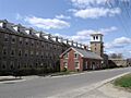
Wauregan Mill
-
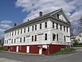
Connecticut Mop Manufacturing Company
-
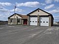
Atwood Hose Fire Company


See also
 In Spanish: Wauregan (Connecticut) para niños
