March Route of Rochambeau's Army: Old Canterbury Road facts for kids
|
March Route of Rochambeau's Army: Old Canterbury Road
|
|

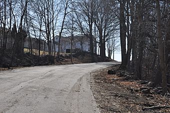
Old Canterbury Road in 2016
|
|
| Location | Old Canterbury Rd: Canterbury Rd. from Jct. with Old Canterbury Rd., Plainfield, Connecticut |
|---|---|
| Area | 2 acres (0.81 ha) |
| MPS | Rochambeau's Army in Connecticut, 1780-1782 MPS |
| NRHP reference No. | 03000310 |
Quick facts for kids Significant dates |
|
| Dates of significance | 1781, 1782 |
| Added to NRHP | June 6, 2003 |
The March Route of Rochambeau's Army: Old Canterbury Road is a special historic place in Plainfield, Connecticut. It's part of the path that French General Rochambeau and his army took during the American Revolutionary War. They marched through here in 1781 and again in 1782.
This site includes parts of what are now Old Canterbury Road and Canterbury Road (also known as Connecticut Route 14A). These roads still look a lot like they did when Rochambeau's soldiers passed by. This area covers about 2 acres (0.8 hectares) and was added to the National Register of Historic Places in 2003. This means it's officially recognized as an important historical spot.
Contents
A Historic March Through Connecticut
This historic road segment is located in western Plainfield, Connecticut. It follows parts of the old and new Connecticut Route 14A. The eastern part of the site is on the modern road, stretching for about 1,300 feet (400 meters) from Old Canterbury Road.
The Old Canterbury Road Section
The western part of the site is Old Canterbury Road itself. This road is narrow and paved. It has shrubs, vines, and old stone walls along its sides. This section was once part of Route 14A until a new road was built in the 1930s.
Trees and Timeless Views
You can find a group of tall sugar maple trees along the road. They provide shade, just as they might have done centuries ago. While some houses nearby are newer, they are set back far enough. This means they don't spoil the feeling of stepping back in time to when Rochambeau's army marched here.
Rochambeau's Journey: 1781 and 1782
This particular stretch of road was used by Rochambeau's troops twice. First, they marched through in June 1781. They were on their way to Virginia to join George Washington and fight the British. Then, in November 1782, they used the same route again. This time, they were returning to Rhode Island after the war ended.
Mapping the Route
The path the French army took is well-documented. A French military engineer named Louis-Alexandre Berthier drew detailed maps of their journey. These maps help us know exactly where they went.
What the Soldiers Saw
French writers who were with the army described the land they passed through. They noted seeing farms growing "rye and wheat, but especially with maize... and with potatoes." They also mentioned "many woods, mostly of oaks and chestnut trees." This was especially true in the area between their third camp in Plainfield and their fourth camp in Windham.
 | John T. Biggers |
 | Thomas Blackshear |
 | Mark Bradford |
 | Beverly Buchanan |


