Bethlehem Village, Connecticut facts for kids
Quick facts for kids
Bethlehem Village, Connecticut
|
|
|---|---|

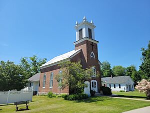
Christ Episcopal Church
|
|

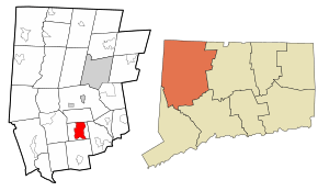
Location in Litchfield County, Connecticut
|
|
| Country | United States |
| State | Connecticut |
| Town | Bethlehem |
| Area | |
| • Total | 8.06 sq mi (20.87 km2) |
| • Land | 7.79 sq mi (20.18 km2) |
| • Water | 0.27 sq mi (0.69 km2) |
| Elevation | 861 ft (262 m) |
| Population
(2010)
|
|
| • Total | 2,021 |
| • Density | 260/sq mi (100.2/km2) |
| Time zone | UTC-5 (EST) |
| • Summer (DST) | UTC-4 (EDT) |
| ZIP Code |
06751
|
| Area code(s) | 860 |
| FIPS code | 09-04945 |
| GNIS feature ID | 2378336 |
Bethlehem Village is a special area in the town of Bethlehem, Connecticut. It is located in Litchfield County, United States. This area is known as a census-designated place (CDP).
The CDP includes the historic center of Bethlehem, called the Bethlehem Green Historic District. It also has homes and countryside around it. In 2010, about 2,021 people lived in Bethlehem Village. The whole town of Bethlehem had 3,607 people at that time.
Contents
Exploring Bethlehem Village's Location
Bethlehem Village covers about 40% of the town of Bethlehem. It stretches from the border with Morris in the north. In the south, it reaches Crane Hollow Road and Porter Hill Road. To the east, it goes to Hard Hill Road N. To the west, it extends to Weekeepeemee Road.
Land and Water Features
The total area of Bethlehem Village is about 20.9 square kilometers (8.1 square miles). Most of this area is land, about 20.2 square kilometers (7.8 square miles). The rest, about 0.7 square kilometers (0.3 square miles), is water. You can find Long Meadow Pond here. The Bronson E. Lockwood Reservoir is also in the northern part of the village.
Main Roads and Travel
Connecticut Route 61 runs through the middle of Bethlehem Village. This road goes north about 8 miles (13 km) to Litchfield. It also goes south about 4 miles (6 km) to U.S. Route 6 in Woodbury.
Connecticut Route 132 crosses Route 61 in the village center. This route goes east about 4 miles (6 km) to Connecticut Route 63 in Watertown. It also goes southwest about 7 miles (11 km) to Connecticut Route 47 in Woodbury.
People and Families in Bethlehem Village
In 2010, there were 2,021 people living in Bethlehem Village. They lived in 840 households. A household is a group of people living in one home. About 573 of these were families.
Who Lives Here?
The population density was about 100 people per square kilometer (260 per square mile). Most people in the CDP were White (97.9%). A small number were African American (0.4%), Native American (0.2%), or Asian (0.3%). About 1.5% of the population was Hispanic or Latino.
Households and Ages
About 26.4% of households had children under 18 living with them. Many households (57.0%) were married couples living together. About 26.4% of all households were individuals living alone. Some people living alone were 65 years old or older (12.3%). The average household had 2.37 people. The average family had 2.88 people.
The median age in Bethlehem Village was 47.0 years. This means half the people were older and half were younger than 47.
- 19.3% of the people were under 18 years old.
- 19.4% were between 25 and 44 years old.
- 38.4% were between 45 and 64 years old.
- 15.0% were 65 years old or older.
For every 100 females, there were about 99.9 males.
Income and Living Standards
From 2013 to 2017, the average household income was estimated to be $90,125. The average family income was $110,781. The average income per person in the CDP was $47,614. A small percentage of families (1.4%) and the total population (6.0%) lived below the poverty line.
See also
 In Spanish: Bethlehem Village (Connecticut) para niños
 | Janet Taylor Pickett |
 | Synthia Saint James |
 | Howardena Pindell |
 | Faith Ringgold |

