Oakville, Connecticut facts for kids
Quick facts for kids
Oakville, Connecticut
|
|
|---|---|

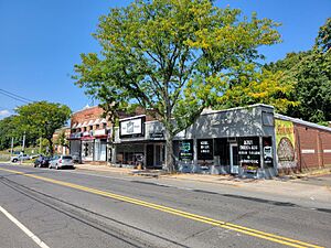
Main Street
|
|

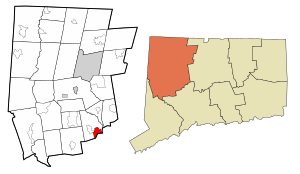
Location in Litchfield County, Connecticut
|
|
| State | Connecticut |
| County | Litchfield |
| Town | Watertown |
| Area | |
| • Total | 3.28 sq mi (8.50 km2) |
| • Land | 3.25 sq mi (8.41 km2) |
| • Water | 0.03 sq mi (0.09 km2) |
| Elevation | 395 ft (120 m) |
| Population
(2010)
|
|
| • Total | 9,047 |
| • Density | 2,787/sq mi (1,075.9/km2) |
| ZIP Code |
06779
|
| FIPS code | 09-56690 |
| GNIS feature ID | 209448 |
Oakville is a community located in Watertown, in Litchfield County, Connecticut, United States. It's known as a census-designated place (CDP), which means it's an area identified by the U.S. Census Bureau for statistical purposes.
In 2010, about 9,047 people lived in Oakville. It is the largest community in Watertown, with more than twice the population of the main village of Watertown. The ZIP code for Oakville is 06779.
Contents
Where is Oakville Located?
Oakville is in the southeastern part of Watertown. It shares borders with the village of Watertown to the northwest. To the south, it borders the city of Waterbury.
The Connecticut Route 8 freeway runs along the eastern side of Oakville. You can get onto this road from Connecticut Route 262. Oakville is also about 3 miles (5 km) north of Interstate 84 in Waterbury. It is 2 miles (3 km) southeast of U.S. Route 6.
Oakville's Land and Water
The United States Census Bureau reports that Oakville covers a total area of about 3.3 square miles (8.5 square kilometers). Most of this area is land. Only a small part, about 0.04 square miles (0.1 square kilometers), is water.
A stream called Steele Brook flows through Oakville. This brook is a small river that eventually joins the Naugatuck River. In the middle of town, there is a dam on Steele Brook. This dam creates a small body of water known as Pin Shop Pond.
Who Lives in Oakville?
Based on the census from the year 2000, there were 8,618 people living in Oakville. These people lived in 3,255 households, and 2,369 of these were families.
The population density was about 2,727 people per square mile (1,053 people per square kilometer). There were 3,358 housing units in total.
Population Details
The people living in Oakville came from different backgrounds:
- About 95.7% were White.
- About 1.2% were African American.
- About 1.1% were Asian.
- About 2.8% of the population identified as Hispanic or Latino.
Households and Families
Out of all the households:
- 33.7% had children under 18 living with them.
- 58.0% were married couples living together.
- 10.8% were led by a female with no husband present.
- 23.2% of households were made up of people living alone.
- 10.0% had someone living alone who was 65 years old or older.
The average household had about 2.64 people. The average family had about 3.13 people.
Age Groups
The population in Oakville was spread out by age:
- 24.8% were under 18 years old.
- 6.8% were between 18 and 24 years old.
- 31.6% were between 25 and 44 years old.
- 23.0% were between 45 and 64 years old.
- 13.8% were 65 years old or older.
The median age in Oakville was 38 years. This means half the people were younger than 38 and half were older.
Income Information
In 2000, the median income for a household in Oakville was $48,395. For a family, the median income was $59,417. The average income per person in the community was $20,763.
A small number of families (1.6%) and people (3.2%) lived below the poverty line. This included 1.0% of those under 18 and 5.7% of those 65 or older.
Local News and Media
Oakville is served by a few local newspapers that keep residents informed:
- Waterbury Republican-American: This is a daily newspaper based in Waterbury.
- Town Times: This local newspaper covers news for Watertown, Oakville, and nearby towns like Thomaston.
See also
 In Spanish: Oakville (Connecticut) para niños
 | Charles R. Drew |
 | Benjamin Banneker |
 | Jane C. Wright |
 | Roger Arliner Young |

