Naugatuck River facts for kids
Quick facts for kids Naugatuck River |
|
|---|---|

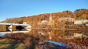
Naugatuck River in Oakville from Whitestone Cliffs Trail road walk over Frost Bridge - CT Route 262
|
|
| Native name | Neggutuck |
| Other name(s) | Great River, Nawcatuck |
| Country | United States |
| State | Connecticut |
| Region | Litchfield County and New Haven County |
| Cities | Torrington, Litchfield, Harwinton, Thomaston, Watertown, Waterbury, Naugatuck, Beacon Falls, Seymour, Ansonia, Derby |
| Physical characteristics | |
| Main source | Confluence of West and East Branches Naugatuck River in Torrington, Connecticut 526 ft (160 m) 41°47′49″N 073°07′00″W / 41.79694°N 73.11667°W |
| River mouth | Confluence with Housatonic River Derby, Connecticut 3 ft (0.91 m) 41°18′49″N 073°04′50″W / 41.31361°N 73.08056°W |
| Basin features | |
| Tributaries |
|
The Naugatuck River is a river in the U.S. state of Connecticut. It is about 40 miles (64.7 km) long. The river flows south through the Naugatuck River Valley. It eventually joins the Housatonic River in Derby, Connecticut. From there, its waters travel about 11 miles (18 km) to Long Island Sound.
A dam called the Plume and Atwood Dam is in Thomaston. It was finished in 1960 after a big flood in 1955. This dam creates a reservoir on the river. It is the last big obstacle for salmon and trout trying to swim upstream from the ocean.
Contents
History of the Naugatuck River Valley
Long ago, different groups of Algonquian peoples, like the Wappinger tribe, lived in the Naugatuck River Valley. The name "Naugatuck" comes from an Algonquian word. It means "lone tree by the fishing place." One writer from the early 1800s said this name first referred to a special tree. This tree was along the river near what is now Beacon Falls. Over time, the name was used for the whole river.
In the 1600s, English colonists started settling in the valley. The soil here was very rocky, which made it hard for farming. However, the river had strong water power. Because of this, the Naugatuck Valley became a busy industrial area in the 1800s. It became well-known for its brass and copper factories.
The River's Journey
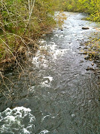
The Naugatuck River starts with two branches. These branches flow through quiet, wooded areas. They meet in downtown Torrington. This meeting point is just north of East Albert Street.
The East Branch of the Naugatuck River is about 11.4 miles (18.3 km) long. It begins in Winchester. It starts as a stream that feeds into Lake Winchester. The West Branch is shorter, about 5.9 miles (9.5 km) long. It forms where three smaller streams meet in western Torrington.
From where the two branches join, the Naugatuck River has always been important for travel. Early paths and roads followed its course. Today, Connecticut Route 8 runs alongside it. The river then flows through a hilly, forested area near Thomaston.
Many industrial cities in the Naugatuck River Valley grew up along the river. These cities include Waterbury and Naugatuck. The river continues its journey, with some wooded parts between the cities. Finally, it flows into the Housatonic River in Derby.
River Life and Protecting It
The Naugatuck River is part of the Housatonic River watershed. In the past, it was home to the southernmost migrations of Atlantic salmon (Salmo salar). Other fish that swam from the sea to lay eggs in the river included American shad (Alosa sapidissima), alewife (Alosa pseudoharengus), and blueback herring (Alosa aestivalis).
Starting around 1763, people built dams on the river. These dams were used to create power for factories. They also provided water for cooling and cleaning in industries. Over time, these dams and pollution from towns harmed many fish species. Many types of fish disappeared from the river.
As factories closed, many dams were no longer needed. They didn't produce power or serve any other purpose. So, several dams were removed in 1999, including the Anaconda Dam and Freight Street Dam in Waterbury. The Kinneytown Dam was given a special "fish ladder" that same year. This ladder helps fish swim around the dam.
In 2004, the Chase Brass Dam was removed. A new fish bypass channel was built at the Tingue Dam in Seymour. This was the first of its kind in New England. It allows fish to swim past the dam. This opened up another 32 miles (51 km) of the river for fish to travel. Now, only the Plume and Atwood Dam in Thomaston remains as a barrier to fish migration.
The State of Connecticut Department of Energy and Environmental Protection (DEEP) helps the river's fish population. Each fall, they release extra Atlantic salmon into the Naugatuck River. These salmon come from a project to restore the Connecticut River. DEEP also stocks other fish like native brook trout (Salvelinus fontinalis). They also add non-native sea-run brown trout (Salmo trutta) and rainbow trout (Oncorhynchus mykiss).
Fun Things to Do on the River
The Naugatuck River is a popular spot for fishing in northwestern Connecticut. While not as famous as the Farmington or Housatonic rivers, it offers great opportunities.
The Connecticut Department of Environmental Protection stocks the river with Atlantic salmon. These fish are released between Route 118 in Harwinton/Litchfield and the Thomaston Dam. They are also released from southern Naugatuck to Beacon Falls.
The Naugatuck River has a special "trout management area." This area is between Route 118 and the Thomaston Dam. The rest of the river, from where the East and West Branches meet down to the Kinneytown Dam in Seymour, is known as a "trophy trout stream." This means it's a great place to catch large trout.
One important landmark along the Naugatuck River is Reynolds Bridge. This bridge is in Thomaston and carries Waterbury Road over the river. It was built in 1928 and is listed on the National Register of Historic Places.
 | Aaron Henry |
 | T. R. M. Howard |
 | Jesse Jackson |


