Gloucester City, New Jersey facts for kids
Quick facts for kids
Gloucester City, New Jersey
|
||
|---|---|---|
|
City
|
||
| City of Gloucester City | ||

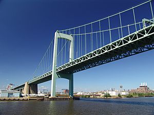
View of downtown Gloucester City from the Walt Whitman Bridge
|
||
|
||
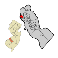
Location of Gloucester City in Camden County highlighted in red (right). Inset map: Location of Camden County in New Jersey highlighted in orange (left).
|
||
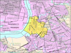
Census Bureau map of Gloucester City, New Jersey
|
||
| Country | ||
| State | ||
| County | Camden | |
| European settlement | 1623 | |
| Incorporated | February 25, 1868 | |
| Named for | Gloucester, England | |
| Government | ||
| • Type | Special charter | |
| • Body | City Council | |
| Area | ||
| • Total | 2.76 sq mi (7.15 km2) | |
| • Land | 2.31 sq mi (6.00 km2) | |
| • Water | 0.45 sq mi (1.16 km2) 16.41% | |
| Area rank | 359th of 565 in state 15th of 37 in county |
|
| Elevation | 23 ft (7 m) | |
| Population
(2020)
|
||
| • Total | 11,484 | |
| • Estimate
(2023)
|
11,507 | |
| • Rank | 219th of 565 in state 12th of 37 in county |
|
| • Density | 4,960.7/sq mi (1,915.3/km2) | |
| • Density rank | 113th of 565 in state 11th of 37 in county |
|
| Time zone | UTC−05:00 (Eastern (EST)) | |
| • Summer (DST) | UTC−04:00 (Eastern (EDT)) | |
| ZIP Codes |
08030
|
|
| Area code(s) | 856 exchanges: 456, 742 | |
| FIPS code | 34007268200 | |
| GNIS feature ID | 0885234 | |
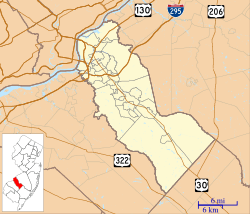
Gloucester City is a city located in Camden County, New Jersey. It sits right across the Delaware River from Philadelphia. In 2020, about 11,484 people lived here.
The city officially became a city on February 25, 1868. Its name comes from Gloucester, England. Gloucester City is also known for having a large Irish American population.
Contents
History
Early Settlements and Fort Nassau
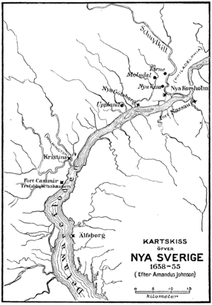
In the 1600s, the Dutch built a trading post called Fort Nassau in what is now Gloucester City. They used it to trade beaver furs with the local Susquehannock and Lenape people. This area along the Delaware River was known as the Zuyd Rivier, marking the southern edge of New Netherland.
From 1638 to 1655, the area was part of New Sweden. This colony was started by Peter Minuit. He was famous for buying the island of Manhattan. The Swedish settlement was not in the best spot for fur trading. The best fur areas were on the other side of the river. In 1651, the Dutch leader, Peter Stuyvesant, moved the fort. He rebuilt it on the other side of the river and called it Fort Casimir. This was partly to challenge the Swedish.
Becoming a City
English Quakers arrived in the Delaware area in 1677. They created a lasting settlement called Axwamus. This settlement was later planned out as a town in 1689. Much later, in 1868, it was officially given a charter to become a city.
Geography
Where is Gloucester City Located?
Gloucester City covers about 2.76 square miles (7.15 square kilometers). Most of this area is land, but about 0.45 square miles (1.17 square kilometers) is water.
Some smaller communities are found within Gloucester City. These include Cloversdale, Gloucester Heights, Highland Park, and Newbold.
Neighboring Towns and Cities
Gloucester City shares borders with several other towns. These include Bellmawr, Brooklawn, Camden, Haddon Township, and Mount Ephraim. It also borders Westville in Gloucester County. Across the Delaware River, it borders the big city of Philadelphia in Pennsylvania.
Population and People
| Historical population | |||
|---|---|---|---|
| Census | Pop. | %± | |
| 1870 | 3,682 | — | |
| 1880 | 5,347 | 45.2% | |
| 1890 | 6,564 | 22.8% | |
| 1900 | 6,840 | 4.2% | |
| 1910 | 9,462 | 38.3% | |
| 1920 | 12,162 | 28.5% | |
| 1930 | 13,796 | 13.4% | |
| 1940 | 13,692 | −0.8% | |
| 1950 | 14,357 | 4.9% | |
| 1960 | 15,511 | 8.0% | |
| 1970 | 14,707 | −5.2% | |
| 1980 | 13,121 | −10.8% | |
| 1990 | 12,649 | −3.6% | |
| 2000 | 11,484 | −9.2% | |
| 2010 | 11,456 | −0.2% | |
| 2020 | 11,484 | 0.2% | |
| 2023 (est.) | 11,507 | 0.4% | |
| Population sources: 1870–2000 1870–1920 1870 1880–1890 1890–1910 1870–1930 1940–2000 2000 2010 2020 |
|||
Who Lives in Gloucester City?
In 2010, there were 11,456 people living in Gloucester City. Most residents were White (about 90.5%). There were also Black or African American (3.1%), Asian (2.7%), and Native American (0.1%) residents. About 6.7% of the population identified as Hispanic or Latino.
The average age in Gloucester City was around 36.7 years old. About 24.5% of the people were under 18.
Economy
Urban Enterprise Zone Benefits
Gloucester City is part of an Urban Enterprise Zone (UEZ). This is a special program in New Jersey. It helps encourage businesses to create jobs and invest in the city.
One benefit of being in a UEZ is a lower sales tax. Shoppers in Gloucester City pay only 3.3125% sales tax. This is half of the usual statewide rate. Gloucester City joined this program in 2004. Its UEZ status will end in August 2024.
Sports and Entertainment
Historic Sports Venues
The Gloucester Point Grounds was once a baseball stadium. The Philadelphia Athletics baseball team played some games there from 1888 to 1890. They played on Sundays to avoid certain laws in Philadelphia.
Famous Visitors and Performers
In 1889, the famous boxer John L. Sullivan had an exhibition match in Gloucester. He faced William Muldoon, a Greco-Roman Wrestling Champion.
Annie Oakley, a famous sharpshooter, also performed in Gloucester City. She gave exhibitions at the Gloucester Point Grounds in 1888 and 1898. This was part of the Pawnee Bill Frontier Exhibition.
Education
Public Schools in Gloucester City
The Gloucester City Public Schools serve students from pre-kindergarten through 12th grade. The district has three schools. These schools include Cold Springs Elementary School (PreK-3), Gloucester City Middle School (grades 4-8), and Gloucester City High School (grades 9-12).
Students from Brooklawn also attend Gloucester City High School. This is part of a special agreement between the school districts.
Catholic Schools
The Roman Catholic Diocese of Camden operates Gloucester Catholic High School. This school is for students in grades 7-12. It opened in 1928.
Saint Mary School was a Catholic elementary school. It closed in 2011. This happened because fewer students were enrolling and the school had financial problems.
Transportation
Roads and Bridges

Interstate 76 is the main highway that goes through Gloucester City. It connects Gloucester City to Philadelphia. It also goes south towards Interstate 295.
The Walt Whitman Bridge carries Interstate 76 over the Delaware River to Philadelphia. This large bridge opened in 1957. U.S. Route 130 also passes through Gloucester City.
Public Transportation Options
NJ Transit offers bus service to Philadelphia. Several bus routes, like 401, 402, 408, 410, and 412, connect Gloucester City to Philadelphia and other towns. There is also a local bus route, 457, that runs between the Moorestown Mall and Camden.
Gloucester City is also planned to be a stop on the Glassboro–Camden Line. This will be a new light rail system.
Notable People from Gloucester City
Many interesting people have connections to Gloucester City. Here are a few:
- James Barton (1890–1962) was a performer in vaudeville shows and movies.
- Agnus Berenato (born 1956) was a college basketball coach for women's teams.
- Jack Collins (born 1943) served as the Speaker of the New Jersey General Assembly.
- Edward Durr (born 1963) is a politician who represents the 3rd Legislative district in the New Jersey Senate.
- Lucinda Florio (1947–2022) was a teacher and a strong supporter of education. She was the First Lady of New Jersey.
- Francis J. Gorman (1924–1987) was a politician who served many terms in the New Jersey General Assembly.
- Patrick T. Harker (born 1958) was the President of the University of Delaware.
- Eliza Leslie (1787–1858) wrote popular cookbooks in the 1800s.
- Betsy Ross (1752–1836) is widely known for creating the Betsy Ross Flag.
See also
 In Spanish: Gloucester City (Nueva Jersey) para niños
 | Chris Smalls |
 | Fred Hampton |
 | Ralph Abernathy |


