Woodsville Brook facts for kids
Quick facts for kids Woodsville Brook |
|
|---|---|

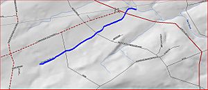
Map of Woodsville Brook
|
|
| Country | United States |
| Physical characteristics | |
| Main source | 40°22′8″N 74°50′27″W / 40.36889°N 74.84083°W |
| River mouth | 197 ft (60 m) 40°23′2″N 74°48′55″W / 40.38389°N 74.81528°W |
| Basin features | |
| Progression | Stony Brook (Millstone River), Millstone River, Raritan River, Atlantic Ocean |
| River system | Raritan River system |
Woodsville Brook is a small stream, also called a tributary, located in Mercer County, New Jersey, in the United States. A tributary is like a smaller river or stream that flows into a larger one. Woodsville Brook flows into the Stony Brook.
About Woodsville Brook
Woodsville Brook is an important part of the local water system. It helps carry water from the land into bigger rivers. This brook is part of the larger Raritan River system, which eventually flows into the Atlantic Ocean.
Where Does Woodsville Brook Flow?
Woodsville Brook begins its journey at a specific spot marked by these coordinates: 40°22′8″N 74°50′27″W / 40.36889°N 74.84083°W. From there, it flows towards the northeast.
As it travels, the brook crosses a few roads. You might see it if you are driving on New Road or Marshalls Corner Woodsville Road. It also flows under Route 31 (Pennington Road) and Route 518 (Lambertville Hopewell Road). These crossings happen close to where those two roads meet.
Finally, Woodsville Brook joins the Stony Brook. This meeting point is located at 40°23′2″N 74°48′55″W / 40.38389°N 74.81528°W. The water from Woodsville Brook then becomes part of the Stony Brook's flow.
Other Streams in the Area
Woodsville Brook isn't the only small stream that flows into the Stony Brook. There are several other streams, sometimes called "sister tributaries," that also feed into it. These include:
All these streams work together to form the larger river system in the area.
 | Sharif Bey |
 | Hale Woodruff |
 | Richmond Barthé |
 | Purvis Young |

