Hightstown, New Jersey facts for kids
Quick facts for kids
Hightstown, New Jersey
|
||
|---|---|---|
|
Borough
|
||
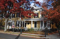
Samuel Sloan House on South Main Street
|
||
|
||
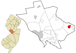
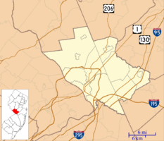
Location of Hightstown in Mercer County highlighted in red (right). Inset map: Location of Mercer County in New Jersey highlighted in orange (left).
<mapframe text="Interactive map of Hightstown, New Jersey" zoom="8" width="250" height="250"> { "type": "ExternalData", "service": "geoshape", "ids": "Q385746" } </mapframe> |
||
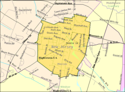
Census Bureau map of Hightstown, New Jersey
|
||
| Country | ||
| State | ||
| County | Mercer | |
| Incorporated | March 5, 1853 | |
| Named for | Hight family | |
| Government | ||
| • Type | Borough | |
| • Body | Borough Council | |
| Area | ||
| • Total | 1.27 sq mi (3.28 km2) | |
| • Land | 1.23 sq mi (3.19 km2) | |
| • Water | 0.03 sq mi (0.09 km2) 2.60% | |
| Area rank | 478th of 565 in state 10th of 12 in county |
|
| Elevation | 92 ft (28 m) | |
| Population
(2020)
|
||
| • Total | 5,900 | |
| • Estimate
(2023)
|
5,853 | |
| • Rank | 352nd of 565 in state 10th of 12 in county |
|
| • Density | 4,785.1/sq mi (1,847.5/km2) | |
| • Density rank | 119th of 565 in state 2nd of 12 in county |
|
| Time zone | UTC−05:00 (Eastern (EST)) | |
| • Summer (DST) | UTC−04:00 (Eastern (EDT)) | |
| ZIP Code |
08520
|
|
| Area code(s) | 609 | |
| FIPS code | 3402131620 | |
| GNIS feature ID | 0885254 | |
| Website | ||
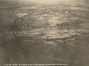
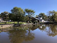
Hightstown is a small town, also called a borough, in Mercer County, New Jersey. It's located in the Raritan Valley region. Hightstown is known for its history, businesses, and culture in Central New Jersey. It's also a diverse suburb for people who work in New York City.
In 2020, about 5,900 people lived in Hightstown. This was the highest number of people ever recorded for the town. The population has been growing steadily over the years. Hightstown became an official borough on March 5, 1853. It was named after John and Mary Hight, who opened a tavern there in the 1750s.
Contents
Where is Hightstown?
Hightstown is about 1.27 square miles (3.28 square kilometers) in size. Most of this area is land, with a small part being water.
The borough is completely surrounded by East Windsor Township. This makes it one of New Jersey's "doughnut towns," where one town completely wraps around another. Hightstown is also located right in the middle of New Jersey. It is roughly the same distance from Philadelphia and New York City.
People of Hightstown
| Historical population | |||
|---|---|---|---|
| Census | Pop. | %± | |
| 1860 | 970 | — | |
| 1870 | 1,347 | 38.9% | |
| 1880 | 1,355 | 0.6% | |
| 1890 | 1,875 | 38.4% | |
| 1900 | 1,749 | −6.7% | |
| 1910 | 1,879 | 7.4% | |
| 1920 | 2,674 | 42.3% | |
| 1930 | 3,012 | 12.6% | |
| 1940 | 3,486 | 15.7% | |
| 1950 | 3,712 | 6.5% | |
| 1960 | 4,317 | 16.3% | |
| 1970 | 5,431 | 25.8% | |
| 1980 | 4,581 | −15.7% | |
| 1990 | 5,126 | 11.9% | |
| 2000 | 5,216 | 1.8% | |
| 2010 | 5,494 | 5.3% | |
| 2020 | 5,900 | 7.4% | |
| 2023 (est.) | 5,853 | 6.5% | |
| Population sources:1860–1920 1870 1880–1890 1890–1910 1910–1930 1940–2000 2000 2010 2020 |
|||
In 2010, there were 5,494 people living in Hightstown. About 69% of the people were White, 8% Black or African American, 4% Asian, and 13% from other backgrounds. About 30% of the population was Hispanic or Latino.
The average household had about 2.7 people. About 24% of the population was under 18 years old. The average age of people in Hightstown was about 37 years old.
Hightstown's Economy
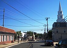
The main business area of Hightstown is called Downtown Hightstown. It is located where Route 33 and County Route 571 meet. Here you can find many restaurants, small shops, art galleries, and historic places.
There's an organization called Downtown Hightstown, Inc. It was started in 2008 by local business owners. Their goal is to show how Hightstown is a great place to visit and live. It's big enough to have many services but small enough to offer friendly, personal service. You can also find many businesses along U.S. Route 130 in nearby East Windsor.
Schools in Hightstown
Students in Hightstown attend public schools that are part of the East Windsor Regional School District. This district serves students from both Hightstown and East Windsor. There are six schools in the district, teaching students from pre-kindergarten all the way through twelfth grade.
The schools include:
- Walter C. Black Elementary School (grades K-2)
- Ethel McKnight Elementary School (grades K-2)
- Perry L. Drew Elementary School (grades 3-5)
- Grace N. Rogers Elementary School (grades PreK / 3-5)
- Melvin H. Kreps Middle School (grades 6-8)
- Hightstown High School (grades 9-12)
Students in grades 7-12 from Roosevelt Borough also attend schools in this district.
Mercer County also has special high school programs called the Mercer County Technical Schools. These schools offer full-time classes in areas like Health Sciences, STEM (Science, Technology, Engineering, Math), and Culinary Arts. Students from Hightstown can apply to attend these schools for free.
Hightstown is also home to the Peddie School. This is a private high school that was founded in 1864.
Historic Places in Hightstown
|
Stockton Street Historic District
|
|
 |
|
| Lua error in Module:Location_map at line 420: attempt to index field 'wikibase' (a nil value). | |
| Location | 126-326 Stockton Street, 219-237 Rogers Avenue, Hightstown, New Jersey |
|---|---|
| Architectural style | Queen Anne, Gothic, Italianate, Federal, Colonial |
| NRHP reference No. | 05001331 |
| Significant dates | |
| Added to NRHP | November 25, 2005 |
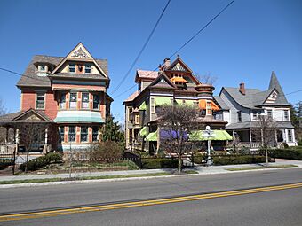
The Stockton Street Historic District is a special area in Hightstown. It includes homes and buildings along Stockton Street and part of Rogers Avenue. This district is famous for its beautiful Victorian houses, the First Methodist Church, and the Hightstown Civil War monument.
This area is also important because of its connection to early railroads. The first railroad in the United States to connect two major cities, New York and Philadelphia, passed through here. Because of its rich history, Hightstown became a Preserve America community in 2015. This program helps protect and celebrate the town's historic places.
Getting Around Hightstown
Hightstown has many roads that help people get around. The main road through the town is Route 33. Other important roads that pass through or near Hightstown include County Route 539, County Route 571, and U.S. Route 130.
Major highways like the New Jersey Turnpike (Interstate 95) and the "Hightstown Bypass" (Route 133) are also close by. They connect with Route 33 at Exit 8 of the Turnpike.
Public Transportation
You can use public transportation to travel from Hightstown. The Route 130 Connection bus goes between the Trenton Transit Center and South Brunswick. There's also a shuttle that connects Hightstown and East Windsor to the Princeton Junction Rail Station.
For trips to New York City, you can take Suburban Coach buses. Route 300 goes to the Port Authority Bus Terminal and Grand Central Terminal in Midtown Manhattan. Route 600 goes to Downtown Manhattan and Wall Street.
Old Railroads
Hightstown used to have train service from the Camden & Amboy Railroad. This was one of the very first railroad companies in New Jersey and the third oldest in the United States! Train service started in Hightstown in December 1831. Over time, different companies owned the railroad lines. Freight train service to Hightstown ended in 1982, and the tracks were removed in 1983.
Healthcare in Hightstown
Hightstown is served by CentraState Healthcare System. This is a large hospital located in nearby Freehold Township. CentraState also has family doctor offices in many towns across central New Jersey, including one in neighboring East Windsor.
Other hospitals close to Hightstown include the Hamilton Division of Robert Wood Johnson University Hospital and Penn Medicine Princeton Medical Center.
Hightstown's Climate
Hightstown has a climate with hot summers and cold winters. Summers can be very hot and humid, sometimes feeling like 100 degrees Fahrenheit (38 degrees Celsius) or more. July is usually the wettest month, with many thunderstorms.
Winters can be very cold and windy, sometimes feeling like 0 degrees Fahrenheit (-18 degrees Celsius) or colder. On average, Hightstown gets about 24 to 30 inches (61 to 76 cm) of snow each winter. February is usually the snowiest month.
| Climate data for Hightstown, Mercer County, New Jersey (1991–2020 normals, extremes 1893–present) | |||||||||||||
|---|---|---|---|---|---|---|---|---|---|---|---|---|---|
| Month | Jan | Feb | Mar | Apr | May | Jun | Jul | Aug | Sep | Oct | Nov | Dec | Year |
| Record high °F (°C) | 73 (23) |
77 (25) |
88 (31) |
95 (35) |
97 (36) |
100 (38) |
105 (41) |
102 (39) |
103 (39) |
95 (35) |
83 (28) |
76 (24) |
105 (41) |
| Mean maximum °F (°C) | 62.8 (17.1) |
62.8 (17.1) |
72.6 (22.6) |
84.3 (29.1) |
89.8 (32.1) |
93.6 (34.2) |
96.4 (35.8) |
94.3 (34.6) |
90.6 (32.6) |
81.9 (27.7) |
73.5 (23.1) |
65.3 (18.5) |
97.5 (36.4) |
| Mean daily maximum °F (°C) | 40.5 (4.7) |
43.0 (6.1) |
50.9 (10.5) |
62.9 (17.2) |
72.8 (22.7) |
81.7 (27.6) |
86.7 (30.4) |
84.9 (29.4) |
78.3 (25.7) |
66.4 (19.1) |
55.3 (12.9) |
45.5 (7.5) |
64.1 (17.8) |
| Daily mean °F (°C) | 31.0 (−0.6) |
32.8 (0.4) |
40.3 (4.6) |
51.0 (10.6) |
60.6 (15.9) |
69.8 (21.0) |
74.9 (23.8) |
72.9 (22.7) |
66.1 (18.9) |
54.3 (12.4) |
44.2 (6.8) |
36.1 (2.3) |
52.8 (11.6) |
| Mean daily minimum °F (°C) | 21.4 (−5.9) |
22.7 (−5.2) |
29.7 (−1.3) |
39.0 (3.9) |
48.4 (9.1) |
57.8 (14.3) |
63.0 (17.2) |
60.8 (16.0) |
53.8 (12.1) |
42.2 (5.7) |
33.0 (0.6) |
26.6 (−3.0) |
41.5 (5.3) |
| Mean minimum °F (°C) | 5.2 (−14.9) |
7.5 (−13.6) |
16.1 (−8.8) |
27.5 (−2.5) |
34.9 (1.6) |
45.3 (7.4) |
53.2 (11.8) |
50.6 (10.3) |
40.2 (4.6) |
28.4 (−2.0) |
19.4 (−7.0) |
12.9 (−10.6) |
2.8 (−16.2) |
| Record low °F (°C) | −16 (−27) |
−11 (−24) |
2 (−17) |
10 (−12) |
28 (−2) |
35 (2) |
42 (6) |
40 (4) |
28 (−2) |
22 (−6) |
0 (−18) |
−12 (−24) |
−16 (−27) |
| Average precipitation inches (mm) | 3.46 (88) |
2.61 (66) |
4.28 (109) |
3.67 (93) |
4.07 (103) |
4.63 (118) |
4.82 (122) |
4.29 (109) |
4.15 (105) |
3.98 (101) |
3.26 (83) |
4.23 (107) |
47.45 (1,205) |
| Average snowfall inches (cm) | 5.8 (15) |
8.0 (20) |
4.6 (12) |
0.6 (1.5) |
0.0 (0.0) |
0.0 (0.0) |
0.0 (0.0) |
0.0 (0.0) |
0.0 (0.0) |
0.0 (0.0) |
0.3 (0.76) |
4.4 (11) |
23.7 (60) |
| Average precipitation days (≥ 0.01 in) | 10.6 | 9.4 | 11.3 | 11.5 | 12.3 | 11.7 | 10.5 | 10.1 | 9.0 | 9.9 | 9.1 | 10.7 | 126.1 |
| Average snowy days (≥ 0.1 in) | 3.2 | 3.4 | 2.3 | 0.3 | 0.0 | 0.0 | 0.0 | 0.0 | 0.0 | 0.0 | 0.1 | 1.7 | 11.0 |
| Source: NOAA | |||||||||||||
Famous People from Hightstown
Many interesting people have lived in or are connected to Hightstown, including:
- Jim Barlow: A soccer coach.
- Kay B. Barrett (1902–1995): A Hollywood talent scout who helped get the movie rights for Gone with the Wind.
- Estelle Brodman (1914–2007): A medical librarian and professor.
- Howard Haycraft (1905–1991): A writer, editor, and publisher.
- Hilly Kristal (1931–2007): The person who started and owned the famous New York City music club, CBGB.
- Larry Kelley (1915–2000): A football player who won the Heisman Trophy in 1936.
- Desiree Lubovska (1893–1974): She founded the American National Ballet School in Hightstown in 1921.
- Doug Mastriano (born 1964): A politician and retired Colonel from the United States Army.
- Worrall Frederick Mountain (1909–1992): A Justice on the New Jersey Supreme Court.
- Elizabeth Greenleaf Pattee (1893–1991): An architect, landscape architect, and architecture professor.
- Randal Pinkett (born 1971): A business consultant who won season four of the TV show The Apprentice.
- Jonathan Sprout (born 1952): A songwriter, performer, and recording artist.
- Martin Waldron (1925–1981): He won a 1964 Pulitzer Prize for his reporting.
- Charles L. Walters (c. 1862–1894): A politician who served in the New Jersey General Assembly.
- Paul Watkins (born 1964): A novelist.
- John Archibald Wheeler (1911–2008): A physicist.
- Nick Williams (born 1990): A wide receiver who played in the NFL.
- John Woodruff (1915–2007): A Gold Medalist in the 800 meters at the 1936 Summer Olympics.
See also
 In Spanish: Hightstown para niños
 | Anna J. Cooper |
 | Mary McLeod Bethune |
 | Lillie Mae Bradford |


