Carters Brook (New Jersey) facts for kids
Quick facts for kids Carters Brook |
|
|---|---|

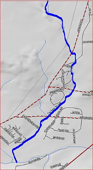
Carters Brook map
|
|
| Country | United States |
| Physical characteristics | |
| Main source | 40°24′23″N 74°35′43″W / 40.40639°N 74.59528°W |
| River mouth | 66 ft (20 m) 40°22′14″N 74°36′9″W / 40.37056°N 74.60250°W |
| Basin features | |
| Progression | Heathcote Brook, Millstone River, Raritan River, Atlantic Ocean |
Carters Brook, sometimes called Carter Brook, is a small stream located in New Jersey, United States. It flows through parts of Somerset and Middlesex counties. This brook is a branch of the Heathcote Brook. It eventually joins other larger waterways like the Millstone River and the Raritan River before its waters reach the Atlantic Ocean.
Where Carters Brook Starts and Ends
Carters Brook begins in a specific spot near the intersection of two roads: Route 518 and Route 27. This starting point is located at coordinates 40°24′23″N 74°35′43″W / 40.40639°N 74.59528°W.
From its source, the brook generally flows south. It passes under roads like Promenade Boulevard and Raymond Road. Finally, Carters Brook flows into the Heathcote Brook. This meeting point is at coordinates 40°22′14″N 74°36′9″W / 40.37056°N 74.60250°W. The elevation at this point is about 66 feet (20 meters) above sea level.
Understanding the Water System
Carters Brook is part of a larger network of rivers and streams. This network is called a river system or drainage basin.
How Water Flows to the Ocean
- Carters Brook flows into the Heathcote Brook.
- The Heathcote Brook then joins the Millstone River.
- The Millstone River flows into the larger Raritan River.
- Finally, the Raritan River empties into the Atlantic Ocean.
This means that water from Carters Brook travels a long way before reaching the sea!
 | Audre Lorde |
 | John Berry Meachum |
 | Ferdinand Lee Barnett |

