
Sayreville, New Jersey facts for kids
Quick facts for kids
Sayreville, New Jersey
|
||
|---|---|---|
|
Borough
|
||
.jpg)
Washington Road (CR 535) in Sayreville descending into the South River valley
|
||
|
||

Sayreville, New Jersey
Location in Middlesex County, New Jersey

Sayreville, New Jersey
Location in New Jersey

Sayreville, New Jersey
Location in the United States
|
||
| Country | ||
| State | ||
| County | Middlesex | |
| Incorporated | April 6, 1876 (as township) | |
| Reincorporated | April 29, 1919 (as borough) | |
| Named for | James R. Sayre Jr. | |
| Government | ||
| • Type | Borough | |
| • Body | Borough Council | |
| Area | ||
| • Total | 18.66 sq mi (48.33 km2) | |
| • Land | 15.83 sq mi (41.00 km2) | |
| • Water | 2.83 sq mi (7.34 km2) 15.24% | |
| Area rank | 153rd of 565 in state 8th of 25 in county |
|
| Elevation | 10 ft (3 m) | |
| Population
(2020)
|
||
| • Total | 45,345 | |
| • Estimate
(2023)
|
45,496 | |
| • Rank | 47th of 565 in state 10th of 25 in county |
|
| • Density | 2,864.5/sq mi (1,106.0/km2) | |
| • Density rank | 227th of 565 in state 19th of 25 in county |
|
| Time zone | UTC−05:00 (Eastern (EST)) | |
| • Summer (DST) | UTC−04:00 (Eastern (EDT)) | |
| ZIP Codes | ||
| Area code(s) | 908, 732 and 848 | |
| FIPS code | 342365790 | |
| GNIS feature ID | 0885386 | |

Sayreville is a town in Middlesex County, New Jersey. It's called a borough, which is a type of local government. Sayreville is located right in the middle of the Raritan Valley area. It sits on the south bank of the Raritan River and is also near the Raritan Bay.
In 2020, about 45,345 people lived in Sayreville. This was an increase of over 2,600 people since 2010. Sayreville first became a township on April 6, 1876. Later, on April 2, 1919, it officially became the Borough of Sayreville.
Contents
- Sayreville's Past: A Look at History
- Sayreville's Location and Surroundings
- Sayreville's Weather: Climate Details
- Sayreville's People: Demographics
- Learning in Sayreville: Education
- Sayreville's Growth: Redevelopment
- Getting Around: Transportation
- Community Life and Fun
- Famous People from Sayreville
- Images for kids
- See also
Sayreville's Past: A Look at History
Early Settlers and the Old Spye Inn
Native Americans were the first people to live in the Sayreville area. The Navesink tribe lived along the South River. This was shown on a map made in 1656 by a Dutch map maker named Adriaen van der Donck.
European settlers came to the area in 1663. They traveled up the Raritan River to buy land from the Native Americans. Later, in the 1900s, people found many old Native American tools and items in the area.
The Morgan Inn was built in 1703 in the Morgan part of Sayreville. It later became known as the Old Spye Inn. The Morgan family, including Major General James Morgan, played important roles in the Revolutionary War. They lived in the area for over 200 years. Many family members are buried in the Morgan Cemetery, which looks out over Raritan Bay.
The Old Spye Inn got its new name during the Revolutionary War. A local story says that in 1777, a British loyalist named Abe Mussey was caught sending signals to British ships. He was tried at the Inn and sentenced to death. He was said to be buried behind the Inn. The Inn burned down in 1976, but its old remains are still there.
From Roundabout to Sayreville: The Brick Industry
The area was first called Roundabout because of the bends in the river. Then it was called Wood's Landing. In the 1860s, it was renamed Sayreville. This name honored James R. Sayre Jr. from Newark. He helped start the Sayre and Fisher Brick Company in the 1850s with Peter Fisher.
Sayreville had a lot of clay, which was perfect for making bricks. The Sayre & Fisher company became one of the biggest brick makers in the world. By 1913, they were making 178 million bricks a year! Over 100 years, they made a total of 6.2 billion bricks.
Other Industries and Events
In 1898, the DuPont company started making gunpowder in Sayreville. Later, they also made paint and photo products here.
The Raritan River Railroad used to run through Sayreville. It had special tracks to serve the brick company and other local businesses. A train from this line was even in a silent movie called The Perils of Pauline in 1914.
In 1918, during World War I, Sayreville was badly damaged by large explosions at the Gillespie Shell Loading Plant. Many people were hurt, and hundreds of buildings were damaged. Even today, old ammunition pieces sometimes appear.
Sayreville's clay also has special scientific value. It's known for having some of the world's best fossils found in amber. Amber is ancient tree sap that trapped insects and plants about 90 million years ago. Back then, Sayreville had a tropical climate. These fossils have been studied by David Grimaldi, a scientist from the American Museum of Natural History.
Sayreville's Location and Surroundings
Sayreville covers about 18.68 square miles (48.37 square kilometers). Most of this area is land, with about 2.85 square miles (7.37 square kilometers) being water.
The borough is on the south side of the Raritan River. Across the river are Woodbridge Township and Perth Amboy. Sayreville also borders Old Bridge Township, East Brunswick, Edison, South Amboy, and South River. It's even close to Staten Island in New York City.
Areas near the Raritan River can sometimes flood during big storms. Sayreville is about 24 miles southwest of Lower Manhattan and 57 miles northeast of Philadelphia. Sayreville uses ZIP Codes 08871 and 08872. Other nearby ZIP codes, 08859 (Parlin) and 08879 (South Amboy), also serve parts of Sayreville.
Sayreville has several distinct areas or neighborhoods. These include Crossmans, Ernston, Gillespie, Laurel Park, MacArthur Manor, Melrose, Morgan, Morgan Heights, Phoenix, Runyon, Sayre Woods, Sayreville Junction, and Sayreville Station.
Sayreville's Weather: Climate Details
Sayreville has a humid subtropical climate. This means it usually has hot and humid summers, and cool to cold winters. Rain and snow are spread throughout the year. The average temperature in July is about 76.1 degrees Fahrenheit (24.5 degrees Celsius). Thunderstorms are common in spring and summer. Sayreville holds the record for the hottest temperature ever in New Jersey. It was 110 degrees Fahrenheit (43 degrees Celsius) on July 10, 1936, in the Runyon neighborhood.
Sayreville's People: Demographics
The 2010 United States census counted 42,704 people living in Sayreville. There were 15,636 households, with 11,414 being families. The population density was about 2,695 people per square mile.
- About 67% of the people were White.
- About 10.7% were Black or African American.
- About 16.1% were Asian.
- About 12.3% were Hispanic or Latino (of any race).
About 22.6% of the population was under 18 years old. The average age was 38.6 years. In 2010, the average household income was about $71,808.
Learning in Sayreville: Education
The Sayreville Public Schools teach students from pre-kindergarten all the way through twelfth grade. For the 2022–23 school year, the district had nine schools and about 6,407 students. This means there was about one teacher for every 11.6 students.
The schools include:
- Cheesequake School (PreK)
- Jesse Selover Preschool (PreK, including programs for children with disabilities)
- Emma L. Arleth Elementary School (Grades K-3)
- Dwight D. Eisenhower Elementary School (Grades K-3)
- Harry S. Truman Elementary School (Grades K-3)
- Woodrow Wilson Elementary School (Grades K-3)
- Samsel Upper Elementary School (Grades 4-5)
- Sayreville Middle School (Grades 6-8)
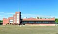
- Sayreville War Memorial High School (Grades 9-12)
Students in eighth grade from all of Middlesex County can apply to special high school programs. These are offered by the Middlesex County Vocational and Technical Schools. They provide career and technical education at different locations, like Middlesex County Academy in Edison.
There are also two Catholic schools in Sayreville: Our Lady of the Victories School (opened 1890) and St. Stanislaus Kostka School (opened 1915). They teach students from Pre-K to 8th grade.
Sayreville's Growth: Redevelopment

Sayreville used to be mostly an industrial town. But now, with more technology companies and people moving in, the town is changing.
There are plans to develop a large area of land, including the old Amboy Cinemas lot. This new development will include shops, businesses, homes, and places for fun. It's a big project that aims to bring new life to the area.
The plan includes a large luxury mall with 1,200,000 square feet of space. There will also be apartments, townhomes, offices, and restaurants by the waterfront. Construction for the first part of this plan began in 2013.
Dealing with Flooding: Flood Plain Buyouts
After Hurricane Sandy in 2012, many areas near the river experienced a lot of flooding. In 2013, the government offered to buy 250 houses in the flood-prone areas. Many residents accepted this offer.
Getting Around: Transportation
_from_the_overpass_for_Middlesex_County_Route_670_(Main_Street)_in_Sayreville,_Middlesex_County,_New_Jersey.jpg)
As of 2010, Sayreville had over 130 miles of roads. Most of these roads are maintained by the town itself.
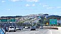
Several major roads and highways go through Sayreville. The Garden State Parkway is the most important highway. U.S. 9 and Route 35 also pass through. Other major highways like the New Jersey Turnpike (Interstate 95) are nearby and easy to reach.

Three highway bridges cross the Raritan River from Sayreville:
- The Edison Bridge on U.S. 9 connects Sayreville to Woodbridge Township. It was replaced in 2003 with a new six-lane bridge.
- The Driscoll Bridge on the Garden State Parkway also connects Sayreville to Woodbridge Township. It's known as one of the "world's widest highway bridges" with 15 lanes!
- The Victory Bridge on Route 35 connects Sayreville to Perth Amboy. The original bridge was built in 1926 and was replaced in 2005.
Buses and Airports
NJ Transit offers bus service from Sayreville to Midtown Manhattan in New York City. Buses also go to Newark and Jersey City.
The Raritan River Railroad used to offer passenger train service to Sayreville until 1938. There have been ideas to use this old train line for a light rail system.
For air travel, the Old Bridge Airport is nearby for short flights. The closest major airports are Newark Liberty International Airport (about 21 miles away) and John F. Kennedy International Airport (about 33 miles away).
Community Life and Fun

Sayreville is home to the Starland Ballroom, a popular place for concerts that opened in 2003.
The community also has the EPIC Church International. This is a very large church, sometimes called a "megachurch," that started in 1980. It has over 10,000 people attending each week and is the biggest church in New Jersey.
Sayreville offers many places for sports and recreation. You can find fields for soccer, football, and basketball courts. There's also a skate park in Kennedy Park for skaters and bikers.
Famous People from Sayreville
Many interesting people have connections to Sayreville, including:
- Jon Bon Jovi (born 1962), the lead singer of the famous rock band Bon Jovi.
- Greg Evigan (born 1953), an actor known for shows like B.J. and the Bear and My Two Dads.
- Dulé Hill (born 1975), an actor who appeared in The West Wing and Psych.
- Tom Kelly (born 1950), a former manager for the Minnesota Twins baseball team.
- Mohamed Sanu (born 1989), a wide receiver who played for the Atlanta Falcons in American football.
- Dave Sabo (born 1964), a rock guitarist in the band Skid Row.
Images for kids
-
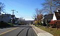
Washington Road in Sayreville
-
Sayreville Seal
-
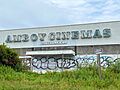
Amboy Cinemas, Sayreville, NJ July 2023
-

View north along the Garden State Parkway in Sayreville
-
The Governor Alfred E. Driscoll Bridge on the Garden State Parkway
-
The Starland Ballroom
See also
 In Spanish: Sayreville para niños
