
Bethlehem Township, New Jersey facts for kids
Quick facts for kids
Bethlehem Township, New Jersey
|
||
|---|---|---|
|
Township
|
||

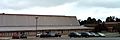
Houses and rolling hills in the township
|
||
|
||

Location of Bethlehem Township in Hunterdon County highlighted in yellow (right). Inset map: Location of Hunterdon County in New Jersey highlighted in black (left).
|
||

Census Bureau map of Bethlehem Township, New Jersey
|
||

Bethlehem Township, New Jersey
Location in Hunterdon County, New Jersey

Bethlehem Township, New Jersey
Location in New Jersey

Bethlehem Township, New Jersey
Location in the United States
|
||
| Country | ||
| State | ||
| County | ||
| Earliest mention | 1730 | |
| Incorporated | February 21, 1798 | |
| Named for | Bethlehem | |
| Government | ||
| • Type | Township | |
| • Body | Township Committee | |
| Area | ||
| • Total | 20.80 sq mi (53.87 km2) | |
| • Land | 20.68 sq mi (53.57 km2) | |
| • Water | 0.12 sq mi (0.30 km2) 0.56% | |
| Area rank | 135th of 565 in state 13th of 26 in county |
|
| Elevation | 814 ft (248 m) | |
| Population
(2020)
|
||
| • Total | 3,745 | |
| • Estimate
(2023)
|
3,756 | |
| • Rank | 422nd of 565 in state 14th of 26 in county |
|
| • Density | 181.1/sq mi (69.9/km2) | |
| • Density rank | 512th of 565 in state 20th of 26 in county |
|
| Time zone | UTC−05:00 (Eastern (EST)) | |
| • Summer (DST) | UTC−04:00 (Eastern (EDT)) | |
| ZIP Code | ||
| Area code(s) | 908 | |
| FIPS code | 3401905650 | |
| GNIS feature ID | 0882189 | |

Bethlehem Township is a community in Hunterdon County, New Jersey. It is part of the larger New York metropolitan area. In 2020, about 3,745 people lived here. This was a small decrease from the 2010 population.
Contents
History of Bethlehem Township
Before Europeans arrived, the Lenape Native Americans lived on this land. Their history is still seen in the names of local places.
Bethlehem Township was first mentioned in records around 1730. It officially became one of New Jersey's first townships on February 21, 1798. Over time, parts of the township were used to create other nearby towns. These include Kingwood Township and Alexandria Township. Other towns formed were Union Township, Hampton, Bloomsbury, and Glen Gardner.
The township was named after the city of Bethlehem.
Geography and Landscape
Bethlehem Township covers about 20.80 square miles (53.87 km2). Most of this area is land, with a small amount of water. The township is located on the edge of the New York metropolitan area. This means it's a bit outside the main city but still connected.
The Musconetcong River forms the northern border of the township. The northern part of the township is a valley. The southern part has the Musconetcong Mountains. The area is mostly rural, with farms and forests. You can also find newer homes and older farmhouses here.
Local Communities and Names
Several small communities are located within the township. These include Charlestown, Jugtown, Ludlow, Polktown, Swinesburg, Valley, and West Portal.
Bethlehem Township shares borders with several other towns. These include Alexandria Township and Bloomsbury. Other neighbors are Glen Gardner and Hampton. It also borders Holland Township, Lebanon Township, and Union Township. In Warren County, it borders Franklin Township, Pohatcong Township, and Washington Township.
Mailing Addresses in the Township
People and businesses in Bethlehem Township use mailing addresses from nearby towns. These towns include Bloomsbury and Clinton. Other addresses are from Glen Gardner, Hampton, and Asbury. "Bethlehem Township" itself is not a mailing address.
Climate and Weather
Bethlehem Township is in the "Northern New Jersey" climate zone. This area has higher lands and valleys. It has a continental climate, meaning it's mostly affected by land, not the ocean.
Winters are usually colder here than in other parts of New Jersey. This is because it's in the northern part of the state. The average snowfall is about 40 to 50 inches per year.
Local Wildlife and Nature
Many animals live in this part of New Jersey. You might see red foxes, black bears, and groundhogs. There are also wild turkeys, deer, squirrels, and chipmunks. Many types of birds and insects live here too.
The area has both deciduous trees (which lose their leaves) and evergreen trees. Black bears are the largest land animals in New Jersey. They are most common in the northwestern parts of the state, including Bethlehem Township.
Population and People
| Historical population | |||
|---|---|---|---|
| Census | Pop. | %± | |
| 1790 | 1,335 | — | |
| 1810 | 1,728 | — | |
| 1820 | 2,002 | 15.9% | |
| 1830 | 2,032 | 1.5% | |
| 1840 | 2,370 | 16.6% | |
| 1850 | 2,746 | 15.9% | |
| 1860 | 1,859 | * | −32.3% |
| 1870 | 2,211 | 18.9% | |
| 1880 | 2,830 | 28.0% | |
| 1890 | 2,308 | −18.4% | |
| 1900 | 1,634 | * | −29.2% |
| 1910 | 980 | * | −40.0% |
| 1920 | 798 | * | −18.6% |
| 1930 | 735 | −7.9% | |
| 1940 | 791 | 7.6% | |
| 1950 | 857 | 8.3% | |
| 1960 | 1,090 | 27.2% | |
| 1970 | 1,385 | 27.1% | |
| 1980 | 3,045 | 119.9% | |
| 1990 | 3,104 | 1.9% | |
| 2000 | 3,820 | 23.1% | |
| 2010 | 3,979 | 4.2% | |
| 2020 | 3,745 | −5.9% | |
| 2023 (est.) | 3,756 | −5.6% | |
| Population sources: 1800–1920 1840 1850–1870 1850 1870 1880–1890 1890–1910 1910–1930 1940–2000 2000 2010 2020 * = Lost territory in previous decade |
|||
What the 2010 Census Showed
In 2010, there were 3,979 people living in Bethlehem Township. There were 1,344 households, which are groups of people living together. Most people (95.65%) were White. About 1.88% were Asian, and 0.98% were Black or African American. About 4.02% of the population identified as Hispanic or Latino.
Many households (41.1%) had children under 18. Most families (77.0%) were married couples. The average household had about 3 people. The average family had about 3.2 people.
About 27.6% of the population was under 18 years old. About 38.4% were between 45 and 64 years old. The average age in the township was 44.2 years.
Parks and Recreation
Spruce Run State Park and Reservoir is a large park near Bethlehem Township. It covers over 2,000 acres. You can walk or bike to Spruce Run from the township. It's a great place for outdoor activities.
Education in Bethlehem Township

Students in Bethlehem Township attend public schools from pre-kindergarten through eighth grade. The Bethlehem Township School District has two schools. In the 2022–23 school year, about 357 students were enrolled.
- Thomas B. Conley Elementary School: This school serves students from pre-kindergarten to 5th grade.
- Ethel Hoppock Middle School: This school is for students in 6th to 8th grade.
For high school, students attend North Hunterdon High School in Annandale. This high school also serves students from several other nearby towns. These include Clinton Town and Clinton Township. Other towns are Franklin Township, Lebanon Borough, and Union Township.
North Hunterdon High School is part of the North Hunterdon-Voorhees Regional High School District. This district also includes Voorhees High School.
Students in eighth grade from all over Hunterdon County can apply to special high school programs. These are offered by the Hunterdon County Vocational School District. These schools teach career and technical skills.
Transportation and Travel
_between_Exit_11_and_Exit_7_in_Bethlehem_Township,_Hunterdon_County,_New_Jersey.jpg)
Roads and Highways
As of 2010, Bethlehem Township had about 57.76 miles of roads. Most of these roads are maintained by the township itself.
The township is well-connected to big cities like New York City and the Lehigh Valley in Pennsylvania. This is thanks to major highways like Interstate 78 and U.S. Route 22. While these highways pass through the township, the closest exits are just outside its borders.
Public Transportation Options
Public transportation in the area is mainly provided by The LINK. This is a public bus service for Hunterdon County. The bus fares usually range from $2.00 to $10.00.
Railroad Lines
The Norfolk Southern Railway's Lehigh Line runs through Bethlehem Township. This railway line used to be part of the Lehigh Valley Railroad. It travels towards Phillipsburg, New Jersey.
Notable People from Bethlehem Township
Many interesting people have connections to Bethlehem Township. They were either born here, lived here, or were closely involved with the community.
- John T. Bird (1829–1911), who served in the United States House of Representatives.
- Johnston Cornish (1858–1920), who also represented New Jersey in the U.S. House of Representatives.
- Anne Marie Letko (born 1969), a long-distance runner who competed in the Summer Olympics.
- Daniel Morgan (1736–1802), a general during the Revolutionary War. He also served as a U.S. Representative.
- James Parker (1776–1868), another member of the U.S. House of Representatives from New Jersey.
- Bennet Van Syckel (1830–1921), who was a Justice on the New Jersey Supreme Court.
Images for kids
-
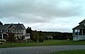
Houses and rolling hills in the township
-
The official seal of Bethlehem Township
-
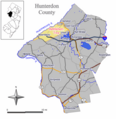
Location of Bethlehem Township in Hunterdon County
-
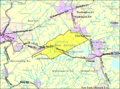
Census Bureau map of Bethlehem Township
-
Thomas B. Conley Elementary School
-
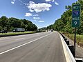
View west along Interstate 78 / U.S. Route 22 in Bethlehem Township
See also
 In Spanish: Municipio de Bethlehem (Nueva Jersey) para niños
