Raritan Township, New Jersey facts for kids
Quick facts for kids
Raritan Township, New Jersey
|
||
|---|---|---|
|
Township
|
||
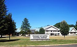
Raritan Township Municipal Complex
|
||
|
||
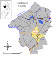
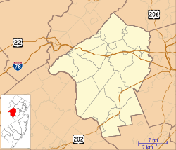
Location of Raritan Township in Hunterdon County highlighted in yellow (right). Inset map: Location of Hunterdon County in New Jersey highlighted in black (left).
|
||
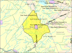
Census Bureau map of Raritan Township, New Jersey
|
||
| Country | ||
| State | ||
| County | ||
| Incorporated | April 2, 1838 | |
| Government | ||
| • Type | Township | |
| • Body | Township Committee | |
| Area | ||
| • Total | 37.65 sq mi (97.52 km2) | |
| • Land | 37.48 sq mi (97.08 km2) | |
| • Water | 0.17 sq mi (0.44 km2) 0.46% | |
| Area rank | 63rd of 565 in state 2nd of 26 in county |
|
| Elevation | 564 ft (172 m) | |
| Population
(2020)
|
||
| • Total | 23,447 | |
| • Estimate
(2023)
|
24,637 | |
| • Rank | 114th of 565 in state 1st of 26 in county |
|
| • Density | 625.6/sq mi (241.5/km2) | |
| • Density rank | 426th of 565 in state 13th of 26 in county |
|
| Time zone | UTC−05:00 (Eastern (EST)) | |
| • Summer (DST) | UTC−04:00 (Eastern (EDT)) | |
| ZIP Code |
08822 – Flemington
|
|
| Area code(s) | 908 | |
| FIPS code | 3401961920 | |
| GNIS feature ID | 0882179 | |
| Website | ||
Raritan Township is a community located in Hunterdon County, in the state of New Jersey. It's called a township, which is a type of local government area. In 2020, about 23,447 people lived here. This was a small increase from 2010.
The township is in the middle of the Amwell Valley and Raritan Valley areas. Rivers like the South Branch of the Raritan River and the Neshanic River flow through it. The northwestern part of the township is on the Hunterdon Plateau, which is a higher area of land.
Raritan Township officially became a township on April 2, 1838. It was formed from parts of an older township called Amwell. Over the years, some parts of Raritan Township were given to other nearby towns. The town of Flemington is actually located completely inside Raritan Township.
The name "Raritan" comes from the Raritan tribe. They were a group of Native American people called Lenape who used to live in Central New Jersey. The name "Raritan" might mean "forked river," "stream overflows," or "point on a tidal river."
Contents
Geography of Raritan Township
Raritan Township covers about 37.65 square miles (97.52 square kilometers). Most of this area is land, with a small amount of water.
Surrounding Areas and "Doughnut Towns"
Raritan Township completely surrounds the town of Flemington. This makes it one of 21 "doughnut towns" in New Jersey, where one town completely wraps around another.
Raritan Township shares its borders with several other towns. These include Clinton Township, Delaware Township, East Amwell Township, Franklin Township, and Readington Township, all in Hunterdon County. It also borders Hillsborough Township in Somerset County.
Local Communities within Raritan Township
Many smaller communities and places are located within Raritan Township. Some of these include Cloverhill, Copper Hill, Croton, Flemington Junction, Klinesville, Larisons Corners, Muirhead, and Reaville.
Distance to Major Cities
Raritan Township is located about 47.7 miles (76.8 kilometers) east of Allentown. It's about 51.7 miles (83.2 kilometers) north of Philadelphia. And it's about 64.9 miles (104.4 kilometers) southwest of New York City.
Population and People
The population of Raritan Township has grown quite a bit over the years. In 1840, there were about 2,510 people. By 2020, the population had grown to 23,447.
Quick Facts from the 2010 Census
In 2010, there were 22,185 people living in Raritan Township.
- Most people (about 89.6%) were White.
- About 2.1% were Black or African American.
- About 6% were Asian.
- About 5.1% of the population identified as Hispanic or Latino.
The average household had about 2.72 people, and the average family had about 3.19 people. About 26.2% of the population was under 18 years old. The median age was 42.4 years. This means half the people were younger than 42.4 and half were older.
Education in Raritan Township
Students in Raritan Township attend public schools from pre-kindergarten up to eighth grade through the Flemington-Raritan Regional School District. This district also serves students from Flemington.
Flemington-Raritan Regional School District
The district has six schools and teaches about 3,079 students. There are about 327 teachers, meaning there are about 9.4 students for every teacher.
- There are four elementary schools for grades K-4: Barley Sheaf School, Copper Hill School, Francis A. Desmares School, and Robert Hunter School.
- Reading-Fleming Intermediate School is for grades 5 and 6.
- J. P. Case Middle School is for grades 7 and 8.
Raritan Township has seven out of the nine spots on the school board for this district.
Hunterdon Central Regional High School District
For high school, students in ninth through twelfth grades go to Hunterdon Central Regional High School. This high school serves students from Raritan Township and other nearby towns like Delaware Township, East Amwell Township, Flemington, and Readington Township.
In the 2018–19 school year, the high school had about 2,844 students and 238 teachers. This means there were about 11.9 students for every teacher. Raritan Township has three out of the nine spots on the high school district's board of education.
Vocational School Options
Students in eighth grade from all over Hunterdon County can apply to attend programs at the Hunterdon County Vocational School District. This district offers special career and technical training at its campuses, including one in Raritan Township. Students don't have to pay tuition to attend these programs.
Transportation in Raritan Township
Raritan Township has many roads. As of 2010, there were about 181.46 miles (292.03 kilometers) of roads. Most of these are maintained by the township itself.
Major Roads
Several important roads pass through Raritan Township:
- Route 12
- Route 31
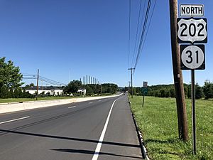
- U.S. Route 202 (Route 31 and U.S. Route 202 run together for about 4 miles in the southern part of the township).
There are also major county roads like CR 514, CR 523, and CR 579. The closest major highway is Interstate 78, which is in nearby Clinton and Franklin Townships.
Public Transportation
The Hunterdon County LINK provides local bus service. These buses connect Flemington to other towns like Lambertville and Hampton. They also go to places like Milford, Clinton, and even to the Bridgewater Commons Mall and Somerville.
Rail Service
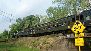
The Black River and Western Railroad is a historic short-line railroad that goes through the township. Today, it operates as a heritage railway, which means it's used for special trips and events, often for fun or historical purposes.
The Norfolk Southern Railway's Lehigh Line also runs through the northeast part of Raritan Township. This line was once the main route for the Lehigh Valley Railroad.
Points of Interest and History
Raritan Township has some interesting historical sites.
The Ambush of Geary
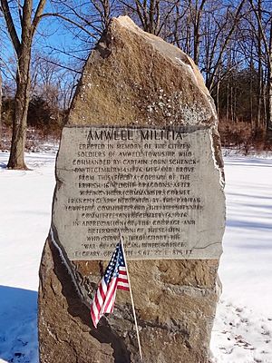
During the American Revolutionary War, on December 14, 1776, a local group of soldiers called the militia, led by Captain John Schenck, surprised a group of British soldiers. This event is known as the Ambush of Geary. The British leader, Cornet Francis Geary, was killed during this fight. It happened between Copper Hill and Larison's Corners.
In 1976, a monument was dedicated to the Amwell Militia at this site, along US 202 and Route 31. There is also a memorial for Geary nearby, along with a sign explaining the skirmish.
John Reading Farmstead
The John Reading Farmstead was built in 1760 for John Reading. He was a former governor of the Province of New Jersey, which was what New Jersey was called before it became a state. This farmstead is listed on the National Register of Historic Places, meaning it's an important historical site. It's also part of the Raritan–Readington South Branch Historic District.
Notable People from Raritan Township
Many interesting people have lived in or are connected to Raritan Township:
- Marcia A. Karrow (born 1959): She was a member of the New Jersey Senate and also served as mayor of Raritan Township in 1998.
- Orlie Pell (1900–1975): A person who believed in peace and worked as a philosopher and activist.
- Miles Ross (1827–1903): He represented New Jersey in the United States House of Representatives from 1875 to 1883.
- Alex Shaffer (born 1993): An actor who appeared in the 2011 movie Win Win.
Images for kids
See also
 In Spanish: Municipio de Raritan (Nueva Jersey) para niños
 | Dorothy Vaughan |
 | Charles Henry Turner |
 | Hildrus Poindexter |
 | Henry Cecil McBay |


