
Hazlet, New Jersey facts for kids
Quick facts for kids
Hazlet, New Jersey
|
||
|---|---|---|
|
Township
|
||

North Centerville section of the township
|
||
|
||

Location of Hazlet in Monmouth County highlighted in yellow (right). Inset map: Location of Monmouth County in New Jersey highlighted in black (left).
|
||

Census Bureau map of Hazlet, New Jersey
|
||

Hazlet, New Jersey
Location in Monmouth County, New Jersey

Hazlet, New Jersey
Location in New Jersey

Hazlet, New Jersey
Location in the United States
|
||
| Country | ||
| State | ||
| County | Monmouth | |
| Incorporated | February 25, 1848 as Raritan Township | |
| Renamed | November 28, 1967 as Hazlet Township | |
| Named for | John Hazlett | |
| Government | ||
| • Type | Township | |
| • Body | Township Committee | |
| Area | ||
| • Total | 5.67 sq mi (14.68 km2) | |
| • Land | 5.57 sq mi (14.42 km2) | |
| • Water | 0.10 sq mi (0.26 km2) 1.76% | |
| Area rank | 265th of 565 in state 19th of 53 in county |
|
| Elevation | 30 ft (9 m) | |
| Population
(2024)
|
||
| • Total | 20,436 | |
| • Estimate
(2023)
|
20,524 | |
| • Rank | 138th of 565 in state 10th of 53 in county |
|
| • Density | 3,613.8/sq mi (1,395.3/km2) | |
| • Density rank | 185th of 565 in state 19th of 53 in county |
|
| Time zone | UTC−05:00 (Eastern (EST)) | |
| • Summer (DST) | UTC−04:00 (Eastern (EDT)) | |
| ZIP Code |
07730
|
|
| Area code(s) | 732 | |
| FIPS code | 3402530690 | |
| GNIS feature ID | 0882120 | |

Hazlet is a township in Monmouth County, New Jersey. It's located near the Raritan Bay in the Raritan Valley region. Hazlet is part of the New York Metropolitan Area. Many people who live here work in New York City, making it a "bedroom community."
As of the 2020 United States census, about 20,125 people lived in Hazlet. This number has changed a bit over the years.
Contents
Hazlet Township: A Look at Its History
Hazlet Township started out with a different name! It was first called Raritan Township. This happened on February 25, 1848, by a special law from the New Jersey Legislature. It was created from parts of Middletown Township.
How Hazlet Got Its Name
Over the years, some parts of Raritan Township became new towns. These included Holmdel Township, Aberdeen Township (which was Matawan Township), Keyport, Keansburg, and Union Beach.
On November 28, 1967, the township officially changed its name to "Hazlet Township." This name was chosen by the people living there in a vote. The name "Hazlet" comes from Dr. John Hazlett. He owned land in the area near what is now Holmdel Road.
Fun Facts from Hazlet's Past
Hazlet was once home to the very last drive-in movie theater in New Jersey! It was called the Route 35 Drive-In and closed in 1991. Later, another drive-in reopened in Vineland, New Jersey.
Hazlet was also part of a plan called the Bayshore Regional Strategic Plan. This plan aimed to help the towns along the Raritan Bayshore coastline grow. It focused on downtown areas, neighborhoods, maritime history, and nature.
Exploring Hazlet's Geography
Hazlet Township covers an area of about 5.67 square miles (14.68 square kilometers). Most of this is land, with a small amount of water.
Where is Hazlet Located?
Hazlet is located about 37 miles (60 km) south of Manhattan in New York City. It's also about 56 miles (90 km) northeast of Philadelphia.
Neighboring Towns and Areas
Within Hazlet, you'll find smaller communities. These include Centerville, Mechanicsville, North Centerville, South Keyport, Tiltons Corner, Van Marters Corner, and West Keansburg.
Hazlet shares its borders with several other townships and boroughs. These are Aberdeen Township, Holmdel Township, Keansburg, Keyport, Middletown Township, and Union Beach.
Who Lives in Hazlet? Demographics
| Historical population | |||
|---|---|---|---|
| Census | Pop. | %± | |
| 1850 | 4,198 | — | |
| 1860 | 2,979 | * | −29.0% |
| 1870 | 3,443 | * | 15.6% |
| 1880 | 3,891 | 13.0% | |
| 1890 | 1,368 | −64.8% | |
| 1900 | 1,524 | 11.4% | |
| 1910 | 1,583 | 3.9% | |
| 1920 | 1,659 | * | 4.8% |
| 1930 | 1,568 | * | −5.5% |
| 1940 | 1,662 | 6.0% | |
| 1950 | 2,763 | 66.2% | |
| 1960 | 15,334 | 455.0% | |
| 1970 | 22,239 | 45.0% | |
| 1980 | 23,013 | 3.5% | |
| 1990 | 21,976 | −4.5% | |
| 2000 | 21,378 | −2.7% | |
| 2010 | 20,334 | −4.9% | |
| 2020 | 20,125 | −1.0% | |
| 2023 (est.) | 20,524 | 0.9% | |
| Population sources: 1850–1920 1850–1870 1850 1870 1880–1890 1890–1910 1910–1930 1940–2000 2000 2010 2020 * = Lost territory in previous decade. |
|||
Population Snapshot: 2010 Census
In 2010, there were 20,334 people living in Hazlet. There were 7,140 households, which are groups of people living together.
Most people in Hazlet were White (about 91.9%). There were also people who identified as Black or African American (1.5%), Asian (3.4%), and people from other races or mixed races. About 7.9% of the population was Hispanic or Latino.
The average household had about 2.82 people. The average family had about 3.26 people.
Age Groups in Hazlet
- About 22.7% of the people were under 18 years old.
- About 14.6% were 65 years old or older.
- The average age in Hazlet was 42.3 years.
Education in Hazlet
The Hazlet Township Public Schools system serves students from pre-kindergarten all the way through twelfth grade.
Schools in Hazlet
As of the 2022–23 school year, the district has eight schools. There are about 2,703 students and 247 teachers. This means there are about 10.9 students for every teacher.
Here are the schools in the district:
- Sycamore Drive Early Childhood Learning Center (PreK-K)
- Lilian Drive Elementary School (Grades 1–4)
- Middle Road Elementary School (Grades 1–4)
- Raritan Valley Elementary School (Grades 1–4)
- Beers Street Elementary School (Grades 5–6)
- Cove Road Elementary School (Grades 5–6)
- Hazlet Middle School (Grades 7–8)
- Raritan High School (Grades 9–12)
Getting Around Hazlet: Transportation
Hazlet has a good network of roads and public transportation options.
Major Roads and Highways
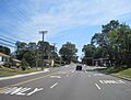
_from_the_overpass_for_Monmouth_County_Route_3_(Lloyd_Road)_in_Hazlet_Township,_Monmouth_County,_New_Jersey.jpg)
Several important roads pass through Hazlet. These include Route 35, Route 36, and County Route 516.
The Garden State Parkway is a major highway that goes through Hazlet. It makes it easy to travel to the Jersey Shore and places further south. It also connects to New York City and areas north. Exit 117, which is for Keyport / Hazlet, is located right in the township.
Public Transportation Options

You can catch a train at the Hazlet station. NJ Transit provides train service on the North Jersey Coast Line. This line can take you to places like Hoboken Terminal, Newark Penn Station, and New York Penn Station in Midtown Manhattan.
NJ Transit also offers local bus service on the 817 route.
Notable People from Hazlet
Many interesting people have connections to Hazlet! Here are a few:
- David Burke (born 1962), a famous chef and restaurant owner.
- Jonathan Capehart (born 1967), a well-known journalist.
- Ray Evernham (born 1957), a former NASCAR crew chief.
- Sammi "Sweetheart" Giancola (born 1987), a TV personality from Jersey Shore.
- Jyllissa Harris (born 2000), a professional soccer player.
- Bennett Jackson (born 1991), a football player for the New York Giants.
- Joey Janela (born 1989), a professional wrestler.
- Jim Ortlieb (born 1956), an actor known for roles in TV shows like Roswell.
- Jerry Recco (born 1974), a sports anchor for WFAN.
- Denise Reddy (born 1970), a former professional soccer player and coach.
- Dave Witte (born 1971), a heavy metal drummer.
Images for kids
-
North Centerville section of the township
-
Seal of Hazlet
-
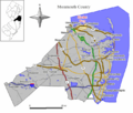
Location of Hazlet in Monmouth County
-
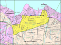
Census Bureau map of Hazlet, New Jersey
-
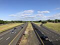
The Garden State Parkway, the largest and busiest highway in Hazlet
-
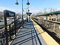
Hazlet train station stop
See also
 In Spanish: Municipio de Hazlet para niños
