Keyport, New Jersey facts for kids
Quick facts for kids
Keyport, New Jersey
|
||
|---|---|---|
|
Borough
|
||
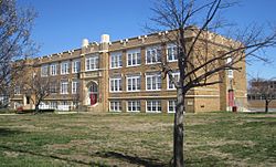
Keyport High School
|
||
|
||
| Nickname(s):
"Pearl of the Bayshore"
|
||
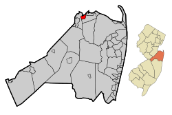
Map of Keyport in Monmouth County. Inset: Location of Monmouth County highlighted in the State of New Jersey.
|
||
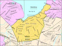
Census Bureau map of Keyport, New Jersey
|
||
| Country | ||
| State | ||
| County | Monmouth | |
| Incorporated | April 2, 1908 | |
| Government | ||
| • Type | Borough | |
| • Body | Borough Council | |
| Area | ||
| • Total | 1.46 sq mi (3.77 km2) | |
| • Land | 1.38 sq mi (3.58 km2) | |
| • Water | 0.07 sq mi (0.19 km2) 5.07% | |
| Area rank | 455th of 565 in state 37th of 53 in county |
|
| Elevation | 26 ft (8 m) | |
| Population
(2020)
|
||
| • Total | 7,204 | |
| • Estimate
(2023)
|
7,099 | |
| • Rank | 315th of 565 in state 25th of 53 in county |
|
| • Density | 5,215.5/sq mi (2,013.7/km2) | |
| • Density rank | 109th of 565 in state 11th of 53 in county |
|
| Time zone | UTC−05:00 (Eastern (EST)) | |
| • Summer (DST) | UTC−04:00 (Eastern (EDT)) | |
| ZIP Code |
07735
|
|
| Area code(s) | 732 | |
| FIPS code | 3402536810 | |
| GNIS feature ID | 0885268 | |
| Website | ||
Keyport is a small town, called a borough, in northern Monmouth County, New Jersey. It's a waterfront community located on the Raritan Bay. Many people who live here travel to New York City for work. Keyport is sometimes called the "Pearl of the Bayshore" or the "Gateway to the Bayshore."
In 2020, about 7,204 people lived in Keyport. The town was first formed on March 17, 1870. It officially became the Borough of Keyport on April 2, 1908.
Keyport is part of a plan to make the area's economy stronger. This plan focuses on downtown areas, neighborhoods, the town's history with the water, and the beautiful coastline. Keyport is also known as an Arts, Cultural, and Entertainment (ACE) Hub. This means it has many arts and cultural activities that attract both visitors and locals.
Contents
Keyport's Location and Size
Keyport is a small borough, covering about 1.46 square miles (3.77 square kilometers). Most of this area is land, with a small part being water.
The borough shares its borders with nearby towns. These include Union Beach, Aberdeen, and Hazlet.
Keyport's Population Over Time
| Historical population | |||
|---|---|---|---|
| Census | Pop. | %± | |
| 1870 | 2,366 | — | |
| 1890 | 3,411 | — | |
| 1900 | 3,413 | 0.1% | |
| 1910 | 3,554 | 4.1% | |
| 1920 | 4,415 | 24.2% | |
| 1930 | 4,940 | 11.9% | |
| 1940 | 5,147 | 4.2% | |
| 1950 | 5,888 | 14.4% | |
| 1960 | 6,440 | 9.4% | |
| 1970 | 7,205 | 11.9% | |
| 1980 | 7,413 | 2.9% | |
| 1990 | 7,586 | 2.3% | |
| 2000 | 7,568 | −0.2% | |
| 2010 | 7,240 | −4.3% | |
| 2020 | 7,204 | −0.5% | |
| 2023 (est.) | 7,099 | −1.9% | |
| Population sources: 1870–1920 1870 1880–1890 1890–1910 1910–1930 1940–2000 2000 2010 2020 |
|||
Population in 2010
In 2010, Keyport had 7,240 people living in 3,067 homes. About 23.4% of homes had children under 18. Many different groups of people live in Keyport. About 80% of the population was White, 7.2% Black or African American, and 2.38% Asian. About 18.26% of the population was Hispanic or Latino.
The average age in Keyport in 2010 was about 40.5 years old.
Keyport's Economy and History
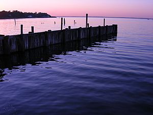
Keyport was once famous for its oyster industry. It was one of the world's biggest suppliers of oysters. However, too much fishing and water pollution caused the industry to decline.
Keyport was also home to the Aeromarine Plane and Motor Company. This company built seaplanes for the United States Navy during World War I. These planes were some of the first to offer scheduled air travel.
Keyport is also said to be where the "Lazy Susan" was invented in 1845. However, this is debated, as similar items existed earlier. Famous film star Fred Astaire made his first professional dance performance in Keyport in 1903. He was only four years old!
Shopping and Dining in Keyport
Keyport has many different businesses and a busy shopping area. This area is on West Front Street, close to the waterfront. The Keyport Bayfront Business Cooperative helps organize events to support local businesses and the town.
You can find many restaurants in Keyport, and some even have live music. A famous chef, Bobby Flay, once filmed a TV show segment at the Broad Street Diner in Keyport.
Education in Keyport
The Keyport Public Schools educate students from pre-kindergarten all the way through twelfth grade. The school district has two schools:
- Keyport Central School: For students in grades Pre-K through 8.
- Keyport High School: For students in grades 9 through 12.
Students from Union Beach also attend Keyport High School.
Getting Around Keyport
Roads and Highways
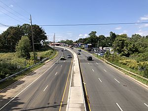
Keyport has about 25.51 miles of roads. Major roads like Route 35 and Route 36 pass through the southern part of town. The Garden State Parkway, a big highway, is also very close by.
Public Transportation
NJ Transit offers local bus service on the 817 route. You can also catch a train nearby at the Hazlet and Aberdeen-Matawan stations. These trains are on the North Jersey Coast Line.
Famous People from Keyport
Many interesting people have connections to Keyport:
- Henry E. Ackerson Jr. (1880–1970): A judge on the New Jersey Supreme Court.
- Piotr Czech (born 1986): An NFL football player who kicks the ball.
- John DeServio: A bass player for the band Black Label Society.
- Juanita Hall (1901–1968): An actress known for her role in the movie South Pacific.
- Garret Hobart (1844–1899): He was the Vice President of the United States from 1897 to 1899. He spent his childhood in Keyport.
- Amy Lamé (born 1971): A performer, writer, and TV/radio presenter.
- Theodore Ryder (1916–1993): One of the first people in the world to be treated with insulin for diabetes when he was five years old.
- Horace M. Thorne (1918–1944): He received the Medal of Honor for being very brave during World War II.
See also
 In Spanish: Keyport para niños
 | Victor J. Glover |
 | Yvonne Cagle |
 | Jeanette Epps |
 | Bernard A. Harris Jr. |


