
West Amwell Township, New Jersey facts for kids
Quick facts for kids
West Amwell Township, New Jersey
|
||
|---|---|---|
|
Township
|
||

West Amwell Township Municipal Building
|
||
|
||

Location of West Amwell Township in Hunterdon County highlighted in yellow (right). Inset map: Location of Hunterdon County in New Jersey highlighted in black (left).
|
||

Census Bureau map of West Amwell Township, New Jersey
|
||

West Amwell Township, New Jersey
Location in Hunterdon County, New Jersey

West Amwell Township, New Jersey
Location in New Jersey

West Amwell Township, New Jersey
Location in the United States
|
||
| Country | ||
| State | ||
| County | ||
| Incorporated | April 6, 1846 | |
| Named for | Amwell Township / Great and Little Amwell, Hertfordshire | |
| Government | ||
| • Type | Township | |
| • Body | Township Committee | |
| Area | ||
| • Total | 21.84 sq mi (56.58 km2) | |
| • Land | 21.65 sq mi (56.07 km2) | |
| • Water | 0.20 sq mi (0.51 km2) 0.90% | |
| Area rank | 129th of 565 in state 12th of 26 in county |
|
| Elevation | 315 ft (96 m) | |
| Population
(2020)
|
||
| • Total | 3,005 | |
| • Estimate
(2023)
|
3,020 | |
| • Rank | 449th of 565 in state 17th of 26 in county |
|
| • Density | 138.8/sq mi (53.6/km2) | |
| • Density rank | 525th of 565 in state 23rd of 26 in county |
|
| Time zone | UTC−05:00 (Eastern (EST)) | |
| • Summer (DST) | UTC−04:00 (Eastern (EDT)) | |
| ZIP Code |
08530 – Lambertville
|
|
| Area code(s) | 609 | |
| FIPS code | 3401978230 | |
| GNIS feature ID | 0882181 | |
| Website | ||

West Amwell Township is a small community in Hunterdon County, New Jersey. It is a type of local government called a township. In 2020, about 3,005 people lived here.
West Amwell became a township on April 6, 1846. This happened when the original Amwell Township was divided. At the same time, East Amwell Township was also created. Later, parts of West Amwell were used to form Lambertville town in 1849. The township was named after Amwell Township, which got its name from towns in England called Great Amwell and Little Amwell.
Contents
Exploring West Amwell's Past
Early Settlers and Native Americans
The first people to live in this area were the Delaware Native Americans. They had a special path through the forests. This path went from Lambertville through Mount Airy, Ringoes, and Reaville. It ended in Newark. This old path later became a road known as the Old York Road.
Farmers' Protest in 1935
In 1935, local farmers in West Amwell stood up for their rights. They signed a statement against a new rule called the Potato Control Law. This law tried to control how many potatoes farmers could grow. The farmers said they would not follow this law. They believed it was unfair and against the country's rules. They wanted to grow and sell their potatoes as they wished.
Discovering West Amwell's Geography
Natural Features and Borders
The northern parts of West Amwell are in a place called Amwell Valley. The southern areas are part of The Sourlands region. The Delaware River forms a natural border on the west side. This river separates West Amwell from the state of Pennsylvania.
The township covers about 21.84 square miles (56.58 square kilometers). Most of this area is land, with a small part being water.
Local Communities and Neighboring Areas
Several small communities and places are found within West Amwell Township. These include Alexauken, Bowlryville, Bowne, Linvale, Mount Airy, Oakdale, and Rocktown.
West Amwell shares its borders with several other towns and counties. In Hunterdon County, it borders Delaware Township, East Amwell Township, and Lambertville. It also borders Hopewell Township in Mercer County. Across the Delaware River in Pennsylvania, it borders New Hope and Solebury Township.
Understanding West Amwell's Population
| Historical population | |||
|---|---|---|---|
| Census | Pop. | %± | |
| 1850 | 1,175 | * | — |
| 1860 | 1,089 | −7.3% | |
| 1870 | 1,030 | −5.4% | |
| 1880 | 1,039 | 0.9% | |
| 1890 | 866 | −16.7% | |
| 1900 | 839 | −3.1% | |
| 1910 | 866 | 3.2% | |
| 1920 | 735 | −15.1% | |
| 1930 | 788 | 7.2% | |
| 1940 | 975 | 23.7% | |
| 1950 | 1,213 | 24.4% | |
| 1960 | 1,683 | 38.7% | |
| 1970 | 2,142 | 27.3% | |
| 1980 | 2,299 | 7.3% | |
| 1990 | 2,251 | −2.1% | |
| 2000 | 2,383 | 5.9% | |
| 2010 | 3,840 | 61.1% | |
| 2020 | 3,005 | −21.7% | |
| 2023 (est.) | 3,020 | −21.4% | |
| Population sources: 1850–1920 1850–1870 1850 1870 1880–1890 1890–1910 1910–1930 1940–2000 2000 2010 2020 * = Lost territory in previous decade. |
|||
Population Changes Over Time
The population of West Amwell Township has changed quite a bit over the years. In 2010, there were 3,840 people living here. By 2020, the population had decreased to 3,005. This shows how communities can grow and shrink over time.
Who Lives in West Amwell?
In 2010, the census showed that most residents were White. There were also many Black or African American residents. Smaller groups included Asian, Native American, and Pacific Islander people. Some residents identified with two or more races. About 4.8% of the population was Hispanic or Latino.
The average household had about 2.58 people. The average family had about 2.95 people. About 16.5% of the population was under 18 years old. About 11.4% were 65 years or older. The median age was 40.8 years.
Learning in West Amwell: Education
South Hunterdon Regional School District
Students in West Amwell Township attend schools in the South Hunterdon Regional School District. This district serves students from pre-kindergarten all the way through twelfth grade. It includes students from Lambertville, Stockton, and West Amwell Township.
The district has three schools. The South Hunterdon Regional Elementary School serves grades PreK–4. The South Hunterdon Regional Middle School is for grades 5–8. Older students attend South Hunterdon Regional High School for grades 9–12. The district has a good student-to-teacher ratio, meaning smaller class sizes.
Changes to the School District
In 2013, voters decided to combine the school districts of Lambertville, Stockton, and West Amwell. This created one big regional district for all grades, PreK–12. This change helps manage resources and education across the communities. West Amwell Township has three members on the school board.
Vocational School Opportunities
Students in Hunterdon County can also apply to the Hunterdon County Vocational School District. This district offers special programs for careers and technical skills. These programs help students learn trades and prepare for specific jobs. There is no tuition cost for students to attend these schools.
Exploring Historic Places
Pleasant Valley Historic District
Part of West Amwell Township is included in the Pleasant Valley Historic District. This is a large historic area that also extends into Hopewell Township in Mercer County. It was added to the National Register of Historic Places in 1991. This means it's a special place recognized for its history in farming, buildings, and early settlement.
Howell Living History Farm
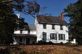
A very important part of this historic district is the Howell Living History Farm. This farm is like a living museum. It shows what farm life was like around the year 1900. Visitors can see how people lived and worked on a farm long ago.
The farm was first bought by a blacksmith named Joseph Phillips in 1732. His son, Henry Phillips, made the farm even bigger. The buildings you see today were mostly built in the 1800s. The Howell family was the last private owner. They gave the farm to Mercer County in 1974 so it could become a museum for everyone to enjoy.
Getting Around West Amwell: Transportation

Roads and Highways
West Amwell Township has many miles of roads. Some are maintained by the township itself. Others are cared for by Hunterdon County or the New Jersey Department of Transportation.
Several important roads pass through or near the township. Route 29 goes through the southwestern part. Route 31 runs along the eastern border. Route 179 and U.S. Route 202 are in the northwestern part. Major county roads like County Route 518 and County Route 579 also cross the township. The closest major highway, Interstate 295, is just outside the township.
Public Transportation Options
For those who use public transport, NJ Transit offers bus service. The 608 bus route connects West Amwell to Trenton. This helps residents travel to the state capital.
Images for kids
-
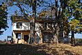
Joseph Phillips Farmhouse
-
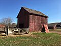
Barn on Joseph Phillips Farm
-

Major Henry Phillips House
-
Historic colonial
-
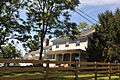
Privately-owned colonial along Woodens Lane


See also
 In Spanish: Municipio de West Amwell para niños
