
Cushetunk Mountain facts for kids
Quick facts for kids Cushetunk Mountain |
|
|---|---|

Cushetunk Mountain (Round Valley Reservoir)
|
|
| Highest point | |
| Elevation | 834 ft (254 m) |
| Geography | |

Cushetunk Mountain
Location in Hunterdon County, New Jersey
|
|
| Location | Hunterdon County, New Jersey, U.S. |
| Topo map | USGS Flemington |
| Geology | |
| Age of rock | 200,000,000 years |
| Mountain type | Intrusive igneous / trap rock |
| Climbing | |
| Easiest route | Hike |
Cushetunk Mountain is a special ring-shaped mountain in New Jersey, USA. It's located in Hunterdon County. The mountain is shaped like a horseshoe, and in the middle of it is a large lake called Round Valley Reservoir.
Long ago, the Lenape Native Americans lived here. They called the mountain "Cushetunk," which means "place of hogs." This was because wild hogs lived there. Today, the mountain and its lake are very important. They provide water for many towns in Central New Jersey. They also offer fun activities like hiking and exploring.
Contents
What is Cushetunk Mountain Like?
Cushetunk Mountain is shaped like a giant horseshoe. It's about 2 miles (3.2 km) wide. The open ends of the horseshoe point west towards the New Jersey Highlands. The biggest part of the mountain is in the southwest.
Right in the middle of this horseshoe shape is a deep, man-made lake. This lake is the Round Valley Reservoir. It was created by building a dam in the 1960s.
Sometimes, people also include Round Mountain when talking about Cushetunk Mountain. Round Mountain is a smaller peak, about 610 feet (186 meters) tall. It's located about 1.5 miles (2.4 km) south. These two mountains are connected underground by a type of rock called diabase.
A Look Back: History of the Mountain
Before Europeans arrived, the Lenape people lived around Cushetunk Mountain. They were part of the Musconetcong group. There's an old story from one of the first European explorers, Beauchamp Plantagenet. He claimed that a Native American king had his home in a valley that sounded like the one inside Cushetunk Mountain. But no one has ever found proof of this "Raritan king."
Some famous people from New Jersey's early history owned land here. John Stevens owned land on the north side of the mountain. His grandson later started the Stevens Institute of Technology. Another famous person was Lord Stirling. He was a general in the American Revolutionary War, ranking high up with George Washington.
In the past, wild animals like wolves lived on Cushetunk Mountain. There's a story about Dr. John Rockhill, an early doctor in Hunterdon County. It says that wolves were common here and in nearby Round Mountain. Settlers in Flemington even had to protect themselves from these wolves in winter.
Before the reservoir was built in the 1960s, people used the mountain for timber. It was hard to farm here because of the tough diabase rock in the soil.
How the Mountain Formed: Geology
Cushetunk Mountain formed about 200 million years ago. This was around the time when the Triassic and Jurassic periods met. It's made of a type of rock called diabase, which is an igneous rock. This rock pushed its way into softer shale and sandstone layers underground.
This happened when a huge crack in the Earth, called the Newark Basin, was still active with volcanoes. The mountain's ring shape is not a crater from a volcano. Instead, it formed deep underground. It looks like a sheet of hot magma bent and pushed its way through the existing rock layers.
A cool fact about Cushetunk Mountain's geology is that its rock crosses over older limestone. This is special because it's one of the few places where this type of rock successfully crossed a major fault line called the Ramapo Fault.
Nature and Wildlife: Ecology
Most mountain ridges in New Jersey run north to south. But Cushetunk Mountain runs more east to west because of its horseshoe shape. This creates different environments on its slopes.
The north side of the mountain is cooler and shadier. It holds more moisture. This means bigger trees grow here, like black birch, tulip trees, and sugar maples. You can also find many shrubs and plants like wild ginger.
The south side is warmer and drier. Here, you'll mostly see chestnut oaks and red oaks. The trees are not as big, and there are fewer types of shrubs. Grasses and sedges cover most of the ground.
Cushetunk Mountain is home to many woodland birds, including bald eagles that nest there. Wet areas on the north slopes are perfect for amphibians. The rocky areas provide homes for small reptiles.
Fun Things to Do
Cushetunk Mountain and the surrounding area offer many ways to enjoy nature:
- Round Valley Recreation Area
- Cushetunk Mountain Preserve
- Deer Path Park, which includes the Peter Buell Trail
Images for kids
-
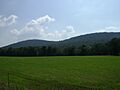
The northeast slope of Cushetunk Mountain

