Vanlieu Corners, New Jersey facts for kids
Quick facts for kids
Vanlieu Corners, New Jersey
|
|
|---|---|
 |
|
| Country | |
| State | |
| County | Hunterdon |
| Township | East Amwell |
| Elevation | 57 m (187 ft) |
| Time zone | UTC−05:00 (Eastern (EST)) |
| • Summer (DST) | UTC−04:00 (EDT) |
| GNIS feature ID | 881433 |
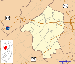
Vanlieu Corners (also known as Van Liew's Corners) is a small place in New Jersey, a state in the United States. It is called an "unincorporated community." This means it does not have its own local government like a town or city. Instead, it is part of a larger area called East Amwell Township in Hunterdon County.
History of Vanlieu Corners
In the past, Vanlieu Corners was a very small settlement. Around the year 1881, it had only a few homes. These homes were built around a local store called Chamberlin & Van Liew.
The children living in Vanlieu Corners went to school in the same district as those from a nearby place called Wertsville. This shows that the communities were connected even back then.
Vanlieu Corners Today
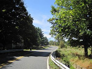
Today, Vanlieu Corners is mostly made up of farmland. You can find it where Wertsville Road (County Route 602) meets Rileyville Road (County Route 607).
The area is located on the northern side of the Sourland Mountain. This mountain is a ridge that stretches across parts of New Jersey and Pennsylvania. The land around Vanlieu Corners is mostly open fields and farms.
 | Kyle Baker |
 | Joseph Yoakum |
 | Laura Wheeler Waring |
 | Henry Ossawa Tanner |


