Southampton Township, New Jersey facts for kids
Quick facts for kids
Southampton Township, New Jersey
|
||
|---|---|---|
|
Township
|
||
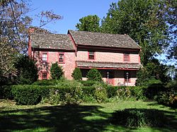
Bishop–Irick Farmstead in Vincentown
|
||
|
||
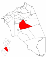
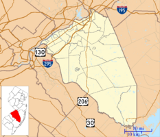
Southampton Township highlighted in Burlington County. Inset map: Burlington County highlighted in the State of New Jersey.
|
||
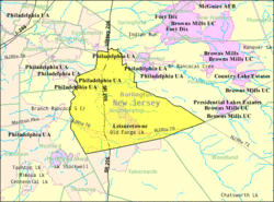
Census Bureau map of Southampton Township, New Jersey
|
||
| Country | ||
| State | ||
| County | ||
| Incorporated | March 10, 1845 as Coaxen Township | |
| Renamed | April 1, 1845 as Southampton Township | |
| Government | ||
| • Type | Township | |
| • Body | Township Committee | |
| Area | ||
| • Total | 44.44 sq mi (115.10 km2) | |
| • Land | 43.96 sq mi (113.85 km2) | |
| • Water | 0.48 sq mi (1.25 km2) 1.08% | |
| Area rank | 44th of 565 in state 7th of 40 in county |
|
| Elevation | 36 ft (11 m) | |
| Population
(2020)
|
||
| • Total | 10,317 | |
| • Estimate
(2023)
|
10,334 | |
| • Rank | 238th of 565 in state 14th of 40 in county |
|
| • Density | 234.7/sq mi (90.6/km2) | |
| • Density rank | 493rd of 565 in state 34th of 40 in county |
|
| Time zone | UTC−05:00 (Eastern (EST)) | |
| • Summer (DST) | UTC−04:00 (Eastern (EDT)) | |
| ZIP Code |
08088
|
|
| Area code(s) | 609 exchanges: 268, 801, 859 | |
| FIPS code | 3400568610 | |
| GNIS feature ID | 0882090 | |
| Website | ||
Southampton Township is a community located in Burlington County, in the state of New Jersey. It's a type of local government area called a township. In 2020, about 10,317 people lived here. Southampton Township is part of a larger area that includes the cities of Philadelphia, Reading, and Camden.
Southampton Township was first created on March 10, 1845. It was originally called Coaxen Township. But just a few weeks later, on April 1, 1845, its name was changed to Southampton Township. As more people moved into the area, parts of the township were used to form other nearby towns. These included Pemberton Township, Shamong Township, Lumberton, Woodland Township, and Tabernacle Township.
Contents
Geography of Southampton Township
Southampton Township covers about 44.44 square miles (115.10 square kilometers). Most of this area is land, with a small amount of water. The township is located within the New Jersey Pine Barrens, which is a special natural area.
Communities and Neighborhoods
Several communities are found within Southampton Township.
- Leisuretowne is a community where many people live. In 2010, about 3,582 people lived there.
- Vincentown is another area within the township.
- Other smaller communities include Beaverville, Buddtown, Burrs Mill, Chairville, Crescent Heights, Ewansville, Ewingville, Hampton Lakes, Medford Park, Oak Shade, Red Lion, Retreat, and Sandtown.
Neighboring Towns
Southampton Township shares borders with several other towns in Burlington County. These include Eastampton Township, Lumberton, Medford, Pemberton Township, Tabernacle Township, and Woodland Township.
The Pinelands National Reserve
Southampton Township is part of the New Jersey Pinelands National Reserve. This is a large protected natural area, covering over 1.1 million acres. It's known for its unique plants and animals. The Pinelands was set up by the U.S. Congress in 1978 to protect this special environment.
Climate in Southampton Township
The weather in Southampton Township changes throughout the year. Here's a look at the average temperatures:
| Month | Jan | Feb | Mar | Apr | May | Jun | Jul | Aug | Sep | Oct | Nov | Dec |
|---|---|---|---|---|---|---|---|---|---|---|---|---|
| High | 42 F | 45 F | 54 F | 65 F | 75 F | 83 F | 87 F | 86 F | 79 F | 69 F | 57 F | 46 F |
| Avg | 36 F | 36 F | 44 F | 54 F | 60 F | 74 F | 77 F | 72 F | 68 F | 54 F | 44 F | 38 F |
| Low | 22 F | 24 F | 31 F | 39 F | 49 F | 58 F | 63 F | 61 F | 54 F | 43 F | 35 F | 27 F |
Population Changes
| Historical population | |||
|---|---|---|---|
| Census | Pop. | %± | |
| 1850 | 3,545 | * | — |
| 1860 | 2,558 | * | −27.8% |
| 1870 | 2,374 | * | −7.2% |
| 1880 | 2,269 | −4.4% | |
| 1890 | 1,849 | −18.5% | |
| 1900 | 1,904 | * | 3.0% |
| 1910 | 1,778 | −6.6% | |
| 1920 | 1,641 | −7.7% | |
| 1930 | 1,637 | −0.2% | |
| 1940 | 1,813 | 10.8% | |
| 1950 | 2,341 | 29.1% | |
| 1960 | 3,166 | 35.2% | |
| 1970 | 4,982 | 57.4% | |
| 1980 | 8,808 | 76.8% | |
| 1990 | 10,202 | 15.8% | |
| 2000 | 10,388 | 1.8% | |
| 2010 | 10,464 | 0.7% | |
| 2020 | 10,317 | −1.4% | |
| 2023 (est.) | 10,334 | −1.2% | |
| Population sources:1850–2000 1850–1920 1850–1870 1850 1870 1880–1890 1890–1910 1910–1930 1940–2000 2000 2010 2020 * = Lost territory in previous decade. |
|||
Population in 2010
In 2010, the census counted 10,464 people living in Southampton Township.
- Most residents (94.50%) were White.
- About 2.21% were Black or African American.
- About 1.33% were Asian.
- People of Hispanic or Latino background made up 2.15% of the population.
The population was quite diverse in age:
- 15.6% of people were under 18 years old.
- 32.0% were 65 years old or older.
- The average age in the township was 53.9 years.
Education in Southampton Township
Students in Southampton Township attend public schools run by the Southampton Township Schools district.
Elementary and Middle Schools
The district has three schools for students from kindergarten through eighth grade:
- Southampton School #1: For students in grades K–2.
- Southampton School #2: For students in grades 3–5.
- Southampton School #3: For students in grades 6–8.
In the 2018–19 school year, there were 734 students and about 70 teachers in these schools. This means there were about 10 students for every teacher.
High School Education
For ninth through twelfth grades, students from Southampton Township go to Seneca High School. This high school also serves students from Shamong Township, Tabernacle Township, and Woodland Township. Seneca High School is part of the Lenape Regional High School District. In 2018–19, the high school had 1,137 students and about 109 teachers.
Vocational and Technical Education
Students from Southampton Township can also attend the Burlington County Institute of Technology. This school offers special training in different jobs and skills. It has campuses in Medford and Westampton.
Getting Around Southampton Township
Roads and Highways
Southampton Township has over 112 miles of roads. The main highways are:
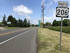
- U.S. Route 206: Runs north and south.
- Route 70: Runs east and west.
These two main roads meet at a place called the Red Lion Circle. Other important roads include Route 38 and County Route 530.
Public Transportation
NJ Transit provides bus service in the township. You can take the 317 bus route to travel between Asbury Park and Philadelphia.
Local Wineries
- DeMastro Vineyards is a winery located in Southampton Township.
Notable People from Southampton Township
Many interesting people have lived in or are connected to Southampton Township:
- Albert Cooper (1904–1993): A soccer goalkeeper who played for the U.S. national team.
- Kyle Criscuolo (born 1992): An ice hockey forward who has played in the NHL.
- Samuel A. Dobbins (1814–1905): He represented New Jersey in the United States House of Representatives.
- Brad Ecklund (1922–2010): A football center who played in the NFL.
- Job H. Lippincott (1842–1900): A judge on the New Jersey Supreme Court.
- Chauncey Morehouse (1902–1980): A famous jazz drummer.
- Jim Saxton (born 1943): A Congressman who served for many years.
See also
 In Spanish: Municipio de Southampton (Nueva Jersey) para niños
 | John T. Biggers |
 | Thomas Blackshear |
 | Mark Bradford |
 | Beverly Buchanan |


