Princeton Junction, New Jersey facts for kids
Quick facts for kids
Princeton Junction, New Jersey
|
|
|---|---|

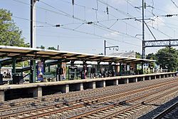
Princeton Junction train station
|
|

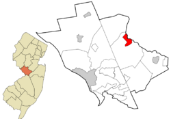
Location in Mercer County (right) and the state of New Jersey (left)
|
|
| Country | |
| State | |
| County | Mercer |
| Township | West Windsor |
| Area | |
| • Total | 1.85 sq mi (4.80 km2) |
| • Land | 1.82 sq mi (4.72 km2) |
| • Water | 0.03 sq mi (0.08 km2) 1.48% |
| Elevation | 60 ft (22 m) |
| Population
(2020)
|
|
| • Total | 2,475 |
| • Density | 1,357.65/sq mi (524.26/km2) |
| Time zone | UTC−05:00 (Eastern (EST)) |
| • Summer (DST) | UTC−04:00 (Eastern (EDT)) |
| ZIP Codes |
08550 (Princeton Junction)
08540 (Princeton) |
| Area code(s) | 609 |
| FIPS code | 34-60960 |
| GNIS feature ID | 02389708 |
Princeton Junction is a small community in New Jersey, a state in the United States. It's located in Mercer County, specifically within West Windsor township. It's called a census-designated place (CDP) because the government counts its population separately. In 2020, about 2,475 people lived there.
Contents
History of Princeton Junction
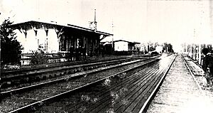
Princeton Junction began to grow in the 1860s. This happened after a major train line, the Camden & Amboy, moved to its current spot. A train station was then built, and a community formed around it.
This early community had farmhouses, a hotel, and a general store. There was also a feed mill and other businesses. They all benefited from being close to the train line, which connected them to other cities.
Early Developments and Growth
In the 1910s, the Berrien City neighborhood was built. This was the first time West Windsor had a planned community. Later, in 1939, the Washington Road railroad bridge was rebuilt. This caused the main business area to move.
The new business center was at the intersection of Washington Road and Cranbury Road. For many years, it had a lumber yard, gas stations, and other shops.
After World War II, more homes were built. This led to a bigger population in Princeton Junction. Some of these new neighborhoods included Sherbrooke Estates and Windsor Chase.
Modern Plans and Historical Records
Today, there are plans for a "transit village" near the train station. This would be a new development focused around public transportation.
In 2019, the Historical Society of West Windsor created an online museum. It shares the history of West Windsor, including the story of Princeton Junction.
Geography of Princeton Junction
Princeton Junction is located in the eastern part of Mercer County. It's in the northern section of West Windsor Township. The Millstone River forms its northeastern border. Across the river is Plainsboro Township.
Bear Brook, a smaller stream, forms the eastern edge of Princeton Junction. The community also reaches north to U.S. Route 1. The state capital, Trenton, is about 11 miles southwest. The town of Princeton is 4 miles northwest.
The Famous Train Station
Princeton Junction gets its name from its train station. This station is on the Amtrak and New Jersey Transit Northeast Corridor line. It's a very important stop.
The station is also where a smaller train line, called the "Dinky," connects. The Dinky train goes directly to Princeton. This makes it easy for people to travel between the two places.
Land and Water Area
Princeton Junction covers about 1.85 square miles. Most of this area is land, about 1.82 square miles. A small part, about 0.03 square miles, is water.
Population and People
| Historical population | |||
|---|---|---|---|
| Census | Pop. | %± | |
| 1990 | 2,362 | — | |
| 2000 | 2,382 | 0.8% | |
| 2010 | 2,465 | 3.5% | |
| 2020 | 2,475 | 0.4% | |
| Population sources: 2000 2010 2020 |
|||
The population of Princeton Junction has grown steadily over the years. In 1990, there were 2,362 people. By 2020, the population had reached 2,475.
What the Census Shows
The 2010 census counted 2,465 people living in Princeton Junction. There were 921 households, which are groups of people living together. Most households, about 68.6%, were married couples.
About 35% of households had children under 18. The average household had 2.66 people.
The population was diverse. About 74.8% of residents were White. About 18.6% were Asian, and 2.4% were Black or African American. People of Hispanic or Latino background made up 5.4% of the population.
The median age in Princeton Junction was 43.3 years. This means half the people were older than 43.3, and half were younger. About 25% of the population was under 18 years old.
Notable People from Princeton Junction
Many interesting people have connections to Princeton Junction. These are people who were born there, lived there, or are closely linked to the community.
- Kevin Barry (born 1978), a baseball player.
- Douglas Forrester (born 1953), who ran for governor.
- Ethan Hawke (born 1970), a well-known actor.
- Matt Lalli (born 1986), a professional lacrosse player. He played for the Boston Cannons.
- Ben H. Love (1930–2010), a leader in the Boy Scouts of America.
- James Murphy (born 1970), a singer and musician. He is known for his band LCD Soundsystem.
- John Forbes Nash Jr. (1928–2015), a brilliant mathematician.
- Bryan Singer (born 1965), a famous film director and producer.
- Note
- Christopher McQuarrie (born 1968), a screenwriter, grew up in Princeton Junction. Some sources say he was born there, while others say he was born in nearby Princeton. Princeton Junction does not have a hospital.
See also
 In Spanish: Princeton Junction para niños
 | John T. Biggers |
 | Thomas Blackshear |
 | Mark Bradford |
 | Beverly Buchanan |


