
Hopewell, New Jersey facts for kids
Quick facts for kids
Hopewell, New Jersey
|
||
|---|---|---|
|
Borough
|
||

Hopewell Station in 2019
|
||
|
||

Location of Hopewell in Mercer County highlighted in red (right). Inset map: Location of Mercer County in New Jersey highlighted in orange (left).
|
||

Census Bureau map of Hopewell, New Jersey
|
||

Hopewell, New Jersey
Location in Mercer County, New Jersey

Hopewell, New Jersey
Location in New Jersey

Hopewell, New Jersey
Location in the United States
|
||
| Country | ||
| State | ||
| County | Mercer | |
| Incorporated | April 14, 1891 | |
| Government | ||
| • Type | Borough | |
| • Body | Borough Council | |
| Area | ||
| • Total | 0.72 sq mi (1.87 km2) | |
| • Land | 0.72 sq mi (1.87 km2) | |
| • Water | 0.00 sq mi (0.00 km2) 0.00% | |
| Area rank | 528th of 565 in state 12th of 12 in county |
|
| Elevation | 197 ft (60 m) | |
| Population
(2020)
|
||
| • Total | 1,918 | |
| • Estimate
(2023)
|
1,894 | |
| • Rank | 489th of 565 in state 12th of 12 in county |
|
| • Density | 2,650.4/sq mi (1,023.3/km2) | |
| • Density rank | 242nd of 565 in state 4th of 12 in county |
|
| Time zone | UTC−05:00 (Eastern (EST)) | |
| • Summer (DST) | UTC−04:00 (Eastern (EDT)) | |
| ZIP Code |
08525
|
|
| Area code(s) | 609 | |
| FIPS code | 3402133150 | |
| GNIS feature ID | 885260 | |

Hopewell is a small town, called a borough, in Mercer County, New Jersey. It is a historic place located in the Raritan Valley region. Many people who live here travel to work in New York City. In 2020, about 1,918 people lived in Hopewell.
Hopewell became an official borough on April 14, 1891. This happened after people voted for it. Later, in 1915 and 1924, more parts of the nearby Hopewell Township joined the borough.
Contents
The History of Hopewell
Hopewell has a long and interesting history, from its first inhabitants to important events that shaped the town.
Early Days and Native Americans

The first people to live in the Hopewell area were the Lenape tribe of Native Americans. Later, in the late 1600s, European settlers arrived. A British governor named Daniel Coxe bought a huge area of land, about 30,000 acres (120 km2). All the land in Hopewell today can be traced back to this purchase.
Coxe then sold his land to a company called The West Jersey Society of England. This company had an agent, Thomas Revell, who was supposed to sell the land. Revell told people from New England, Long Island, and New Jersey that the land was fertile and easy to settle. However, the families who came found only wild land.
The first settler in Hopewell Valley was Thomas Tindall. In 1699, he bought 300 acres (1.2 km2) of land. Other early settlers included the Stouts, who moved to Hopewell in 1706. Jonathan Stout had even hunted in the area with the Lenape people.
There was a big problem when settlers found out their land deeds were not valid because of Revell's false claims. Fifty families sued Revell and the West Jersey Society. The court decided against the settlers. Many had to buy their land again or move away.
The Old School Baptist Church
On April 23, 1715, the settlers who stayed in Hopewell, especially the Stout family, started the Old School Baptist Church. At that time, Hopewell was often called "Baptist Meetinghouse."
An important member of the church was John Hart. He was one of the people who signed the United States Declaration of Independence. In 1740, he bought land in Hopewell. In 1747, he gave some of his land to the Baptists. In 1748, the Baptists built their meeting house on West Broad Street. This church brought many Baptists to Hopewell and helped the town grow.
Many lumber mills were built around Hopewell. They processed wood from the forests that were cleared for farms.
In 1756, Isaac Eaton, the first pastor of the Old School Baptist Church, started the Hopewell Academy. One of his students, James Manning, later founded Brown University in 1765.
The Frog War

The first railroad came to Hopewell in 1874. It was called the Mercer and Somerset Railway. This railroad was built to stop another company, the Delaware and Bound Brook Railroad, from expanding.
The Delaware and Bound Brook Railroad reached Hopewell in 1876. But it had to cross the Mercer and Somerset's tracks. This crossing point was called a "frog." A big argument started between the two railroad companies. Each company parked their trains over the crossing to stop the other from using it. This fight became known as the "Frog War."
Soldiers had to be called in to keep the peace. In the end, the Delaware and Bound Brook Railroad won. The Mercer and Somerset Railway soon closed down. Part of its old track in Hopewell became Model Avenue. The Delaware and Bound Brook line is still used today by CSX. The "Frog War" is also why Hopewell Elementary School's mascot is "Freddy the Frog."
The Hopewell Herald Newspaper

Before the 1960s, the main newspaper for Hopewell was the Hopewell Herald. The Savidge family of Hopewell owned and published this newspaper.
Hopewell's Location and Size
Hopewell is a small town. It covers about 0.72 square miles (1.9 km2) of land. It is completely surrounded by Hopewell Township. This makes it one of 21 "doughnut towns" in New Jersey, where one town is entirely inside another.
Education in Hopewell
Students in Hopewell attend public schools through the Hopewell Valley Regional School District. This school district serves students from Hopewell Borough, Hopewell Township, and Pennington Borough.
The district has six schools:
- Bear Tavern Elementary School (Pre-K–5)
- Hopewell Elementary School (Pre-K–5)
- Stony Brook Elementary School (K–5)
- Toll Gate Grammar School (K–5)
- Timberlane Middle School (6–8)
- Hopewell Valley Central High School (9–12)
Hopewell Borough students go to Hopewell Elementary School. The school board has nine members, with Hopewell having one seat.
Students from all over Mercer County can also apply to special high school programs. These are offered by the Mercer County Technical Schools. They have programs in Health Sciences, STEM (Science, Technology, Engineering, Math), and Culinary Arts. There is no tuition fee for these programs.
Getting Around Hopewell
Hopewell has several main roads that help people travel in and out of the borough.
Major Roads
_at_Greenwood_Avenue_in_Hopewell,_Mercer_County,_New_Jersey.jpg)
As of 2010, Hopewell had about 9.35 miles (15.05 km) of roads. Most of these roads are taken care of by the borough itself.
- County Route 518 comes into Hopewell from the west. It then joins West Broad Street and goes through the town, heading east towards Rocky Hill.
- Pennington Hopewell Road (County Route 654) enters Hopewell from the southwest. It becomes West Broad Street and connects Hopewell to Pennington.
- Princeton Avenue, also known as County Route 569, starts at Broad Street. It goes south and connects Hopewell with Princeton.
- Greenwood Avenue goes north from Hopewell. It connects the town with East Amwell Township.
You can also reach Route 31 using Route 518 and Route 654.
Train Service
NJ Transit is planning to bring back passenger train service to Hopewell. This would be on the West Trenton Line. The plan is to use the existing train tracks that CSX owns.
The proposal includes adding more tracks to increase how many trains can run. A new train station would be built on Somerset Street. The old Hopewell Station is not part of this plan. This train line would connect Hopewell to New York City. You could also get to Philadelphia by connecting to a SEPTA train in West Trenton. Train service to Hopewell ended in 1982, so this would bring it back.
People from Hopewell
Many interesting people have lived in or are connected to Hopewell.
- Danielia Cotton (born 1967), a singer and songwriter.
- John Hart (around 1711–1779), who signed the United States Declaration of Independence. His grave is in the First Baptist Church graveyard.
- Amy Locane (born 1971), an actress who appeared in movies and TV shows like Cry-Baby and Melrose Place.
- James W. Marshall (1810–1885), a sawmill worker. In 1848, he found gold in California. This discovery started the famous California Gold Rush.
- Richard Preston (born 1954), an author known for his book The Hot Zone.
- Keith Robertson (1914–1991), an author who wrote books for children.
Images for kids
-
The official seal of Hopewell Borough.
-
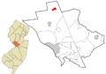
A map showing Hopewell's location in Mercer County, New Jersey.
-
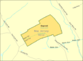
A map of Hopewell from the Census Bureau.
See also
 In Spanish: Hopewell (Nueva Jersey) para niños
