Groveville, New Jersey facts for kids
Quick facts for kids
Groveville, New Jersey
|
|
|---|---|

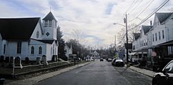
Along Church Street (CR 609)
|
|

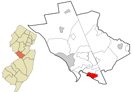
Location in Mercer County and the state of New Jersey
|
|
| Country | |
| State | |
| County | Mercer |
| Township | Hamilton |
| Area | |
| • Total | 2.25 sq mi (5.83 km2) |
| • Land | 2.21 sq mi (5.73 km2) |
| • Water | 0.04 sq mi (0.10 km2) 1.71% |
| Elevation | 49 ft (15 m) |
| Population
(2020)
|
|
| • Total | 3,106 |
| • Density | 1,404.16/sq mi (542.24/km2) |
| Time zone | UTC−05:00 (Eastern (EST)) |
| • Summer (DST) | UTC−04:00 (Eastern (EDT)) |
| ZIP Code |
08620 - Trenton
|
| FIPS code | 34-28620 |
| GNIS feature ID | 02583996 |
Groveville is a small community in Hamilton Township, Mercer County, New Jersey. It is known as an "unincorporated community," which means it's a place with its own identity but isn't officially a town or city. It's also a "census-designated place" (CDP), which is an area the U.S. Census Bureau defines for gathering population data.
In 2020, the population of Groveville was 3,106 people. Before 2010, Groveville was part of a larger CDP called Yardville-Groveville.
Contents
Exploring Groveville's Location
Groveville is located in the southern part of Mercer County. A creek called Crosswicks Creek forms its southern border. This creek also marks the line between Mercer County and Burlington County.
Key Areas within Groveville
The main part of Groveville is in the western area. It's centered around where Main Street and Church Street meet. Another part of the community, called North Crosswicks, is in the southeastern area. It's located at the crossing of South Broad Street and another Church Street. To the north, Groveville borders the community of Yardville.
Travel and Waterways
The New Jersey Turnpike (Interstate 95) passes through the eastern part of Groveville. However, there are no direct exits to Groveville from the turnpike.
Groveville covers about 2.16 square miles (5.59 square kilometers) in total. Most of this area is land, with a small amount of water. Crosswicks Creek drains the southern part of the community. Another stream, Doctors Creek, flows through the northern part. Both of these creeks are part of the larger Delaware River watershed.
Understanding Groveville's Population
The population of Groveville has been counted during different U.S. censuses.
| Historical population | |||
|---|---|---|---|
| Census | Pop. | %± | |
| 2010 | 2,945 | — | |
| 2020 | 3,106 | 5.5% | |
| U.S. Decennial Census 2010 2020 |
|||
Population in 2010
The 2010 United States census counted 2,945 people living in Groveville. There were 1,046 households and 810 families. The population density was about 1,387 people per square mile. This means that, on average, 1,387 people lived in every square mile of land.
Households and Families
- About 38.6% of the households had children under 18 years old.
- Most households (59.3%) were married couples living together.
- About 12.9% of households had a female head with no husband present.
- Roughly 22.6% of households were not families (meaning people living alone or with roommates).
- About 18.2% of all households were made up of individuals living alone.
- Around 6.1% of households had someone living alone who was 65 years old or older.
The average household in Groveville had about 2.81 people. The average family had about 3.21 people.
Age Groups
- 25.1% of the people were under 18 years old.
- 9.7% were between 18 and 24 years old.
- 24.1% were between 25 and 44 years old.
- 30.7% were between 45 and 64 years old.
- 10.4% were 65 years old or older.
The median age in Groveville was 39.6 years. This means half the population was younger than 39.6, and half was older. For every 100 females, there were about 94.6 males.
See also
 In Spanish: Groveville para niños
 | Emma Amos |
 | Edward Mitchell Bannister |
 | Larry D. Alexander |
 | Ernie Barnes |


