Assunpink Creek facts for kids
Quick facts for kids Assunpink Creek |
|
|---|---|

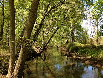
View west along the Assunpink Creek in West Windsor, NJ
|
|
| Country | United States |
| State | New Jersey |
| Region | Monmouth County, Mercer County |
| Physical characteristics | |
| Main source | Millstone Township 240 ft (73 m) 40°12′8″N 74°26′24″W / 40.20222°N 74.44000°W |
| River mouth | Delaware River Trenton 3 ft (0.91 m) 40°12′59″N 74°46′12″W / 40.21639°N 74.77000°W |
| Basin features | |
| River system | Delaware River |
| Tributaries |
|
The Assunpink Creek is a 22.9-mile (36.9 km) long tributary (a smaller river that flows into a larger one) of the Delaware River. It is located in western New Jersey in the United States. The name Assunpink comes from the Lenape people's word Ahsën'pink. This word means "stony, watery place."
Contents
Journey of the Assunpink Creek
The Assunpink Creek starts in a countryside area of Monmouth County. This is about one mile north of Clarksburg. As it flows west, it soon enters the Assunpink Wildlife Management Area. Here, the creek has been blocked by a dam to create Rising Sun Lake.
Lakes and Wildlife Areas
After a smaller stream joins it from the south, the creek flows into another lake called Assunpink Lake. These two lakes, along with Stone Tavern Lake on the smaller stream, are popular places for fishing.
Below Assunpink Lake, the creek goes under Old York Road. It then enters Mercer County. Another stream, New Sharon Branch, joins the creek from the south at Carsons Mills.
Through Mercer County
The creek then turns northwest. It flows under the New Jersey Turnpike and then U.S. Route 130. This is just southwest of Windsor. Here, it finally leaves the Wildlife Management Area.
Further northwest, the creek enters Mercer County Park. A stream called Bridegroom Run joins it from the north. The creek then turns west and is dammed to form Mercer Lake. A small wildlife area, the Van Nest Refuge, is located along the stream just below this dam.
Final Stretch to the Delaware River
The Assunpink Creek then passes under Quaker Bridge Road and Interstate 295. After this, it turns southwest and flows next to the Delaware and Raritan Canal. The creek now enters a busy, built-up area. The Shabakunk Creek and Miry Run join it just above Whitehead Mill Pond. Pond Run joins it near Hutchinson Mills. The creek, which is now like a canal in some parts, flows past the Trenton Transit Center. Finally, it empties into the Delaware River in Trenton.
A Historic Battle at the Creek
The Assunpink Creek played an important role in American history during the American Revolutionary War. On January 2, 1777, a major event known as the Second Battle of Trenton took place here.
George Washington's Stand
During this battle, soldiers from the Continental Army (the American army) and supporting groups of citizen soldiers were led by General George Washington. They set up a strong defense line along the south side of Assunpink Creek, just south of Trenton. This line stretched from where the creek meets the Delaware River all the way up to Philip's Mill.
Repelling the British and Hessians
The American soldiers successfully stopped several attacks by British and Hessian soldiers. Hessian soldiers were German troops hired by the British. The enemy tried to cross a stone bridge over the creek. They also tried to wade across the creek near its mouth. However, the American forces held their ground and pushed them back each time. This victory was a key moment for the Americans in the war.
Images for kids
-
General George Washington at Trenton by John Trumbull
This painting shows Washington on the night of January 2, 1777, with the bridge over the Assunpink Creek in the background.
 | Tommie Smith |
 | Simone Manuel |
 | Shani Davis |
 | Simone Biles |
 | Alice Coachman |


