Shabakunk Creek facts for kids
Quick facts for kids Shabakunk Creek |
|
|---|---|

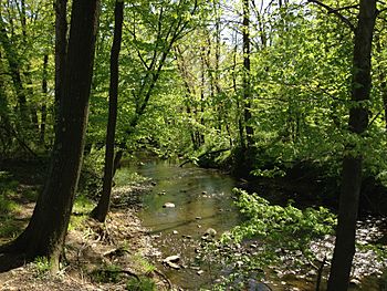
The Shabakunk Creek below Colonial Lake
|
|
| Country | United States |
| State | New Jersey |
| Region | Mercer County |
| Physical characteristics | |
| Main source | The main branch Hopewell Township 217 ft (66 m) 40°18′38″N 74°45′50″W / 40.31056°N 74.76389°W |
| 2nd source | The West Branch Ewing Township 197 ft (60 m) 40°16′50″N 74°48′49″W / 40.28056°N 74.81361°W |
| River mouth | Assunpink Creek Lawrence Township 37 ft (11 m) 40°14′58″N 74°43′9″W / 40.24944°N 74.71917°W |
| Basin features | |
| River system | Assunpink Creek |
| Tributaries |
|
The Shabakunk Creek is a small river, or tributary, that flows into the Assunpink Creek. It is located in Mercer County, New Jersey, in the United States. Eventually, its water joins the Delaware River. The name "Shabakunk" comes from the Lenape people. It means "shore land," which describes the areas along the creek.
Contents
The Creek's Journey
The Shabakunk Creek has two main parts: a longer main branch and a shorter west branch. Both branches flow through different towns in New Jersey before they meet.
Main Branch: From Hopewell to Lawrence
The main branch of the Shabakunk Creek is about 7.9 miles (12.7 kilometers) long. It starts in Hopewell Township. As it flows south, it goes under several roads and joins with other small streams.
It then enters Ewing. Here, it flows into Lake Sylva, a pretty lake on the campus of The College of New Jersey.
After Lake Sylva, the creek continues southeast. It forms a short border between Ewing and Lawrence townships. Then, it meets the West Branch Shabakunk Creek. The creek turns east and flows entirely into Lawrence Township. It passes under more roads and then flows into Colonial Lake.
Below Colonial Lake, the creek goes under a major highway and the Delaware and Raritan Canal. Finally, it reaches its end, flowing into the Assunpink Creek.
West Branch: From Airport to Main Creek
The West Branch of the Shabakunk Creek is about 5.3 miles (8.5 kilometers) long. It begins near the Trenton-Mercer Airport in Ewing. It flows generally southeast, picking up water from smaller streams.
This branch passes under many roads. Much of the West Branch has been changed by human development. Some parts of the creek have been straightened or built over. This is because of many businesses and buildings in the area. Eventually, the West Branch joins the main branch of the Shabakunk Creek.
History of the Creek
The Shabakunk Creek has played a role in both historical events and modern challenges.
Revolutionary War Skirmish
During the American Revolutionary War, a small but important battle happened near the Shabakunk Creek. On January 2, 1777, American soldiers fought British forces here. This fight helped slow down the British. It stopped them from reaching Trenton before nightfall. This event was part of the Battle of the Assunpink Creek, also known as the Second Battle of Trenton.
Dealing with Flooding
In 1996, the West Branch of the Shabakunk Creek experienced a very big flood. Over 7 inches (18 centimeters) of rain fell in just four hours. This caused about $10 million in damages to homes and businesses. Many places had to close for weeks.
Because of this flood, a large project was started. It cost $4.2 million to help control future floods. Workers strengthened the creek banks. They also built special areas called detention basins. These basins help hold extra stormwater during heavy rains. This prevents water from overflowing the creek.
Environmental Concerns
Like many urban waterways, the Shabakunk Creek faces environmental challenges.
Past Pollution from Twin Pines Airport
The main branch of the Shabakunk Creek starts near an area that was once the Twin Pines Airport. This airport was open for over 60 years. It was a busy place with many planes.
In 2008, environmental checks found that parts of the airport land were polluted. This was due to oil and fuel leaking from underground tanks. These leaks had been happening for a long time. The pollution spread into the ground. It reached areas where the creek's small streams begin. Old containers of oil and other fluids were also found dumped in ditches nearby. This pollution could affect the creek's water quality.
High Mercury Levels in the Creek
Studies have shown that all parts of the Shabakunk Creek have medium to high levels of mercury. Mercury is a heavy metal that can be harmful. These studies are done by government groups and scientists.
The pollution from the old Twin Pines Airport is thought to be a main source of this mercury. The mercury has been found in fish and in the creek's bottom sediments. Some studies found mercury levels much higher than what is considered safe. This shows how important it is to protect our waterways from pollution.
Images for kids
 | James Van Der Zee |
 | Alma Thomas |
 | Ellis Wilson |
 | Margaret Taylor-Burroughs |


