
Upper Manhattan facts for kids

Upper Manhattan is the northern part of Manhattan, a famous island in New York City. It's known for its unique neighborhoods and rich history. People often call this area "Uptown."
The exact southern border of Upper Manhattan can be a bit tricky. Some people say it starts at 96th Street. Others think it begins at 110th Street, which is the top edge of Central Park. Sometimes, 125th Street or even 155th Street are used as the starting point. When people say "Uptown," they usually mean neighborhoods north of 59th Street, which includes all of Upper Manhattan.
Upper Manhattan is home to many cool neighborhoods. These include Marble Hill, Inwood, and Washington Heights. Washington Heights also has smaller areas like Fort George and Hudson Heights. You'll also find Harlem, which includes Sugar Hill and Hamilton Heights. Other neighborhoods are East Harlem, Morningside Heights, and Manhattan Valley.
The George Washington Bridge is a huge bridge that connects Washington Heights in Upper Manhattan to Fort Lee, New Jersey. It crosses the Hudson River. This bridge is super busy and is used by more cars than any other bridge in the world!
In the late 1800s, new train lines like the IRT Ninth Avenue Line helped people move to Upper Manhattan. Before that, it was mostly quiet and rural. For a long time, this area didn't change as much as other parts of New York City.
Contents
Fun Places to Visit in Upper Manhattan
Upper Manhattan is mostly a place where people live, but it has many interesting spots to explore! It's not a main tourist area, but there are lots of cool things to see and do.
Famous Landmarks
- Grant's Tomb: This is the final resting place of Ulysses S. Grant, a famous American general and president.
- Apollo Theater: A legendary music hall in Harlem where many famous musicians have performed.
- United Palace: A beautiful old theater that hosts concerts and events.
- The Cloisters: This amazing museum looks like a medieval European monastery. It's part of the Metropolitan Museum of Art and has incredible old art.
- Sylvia's Restaurant: A very famous restaurant known for its delicious soul food.
- Hamilton Grange: The historic home of Alexander Hamilton, one of America's founding fathers.
- Morris–Jumel Mansion: The oldest house in Manhattan, full of history.
- Minton's Playhouse: A historic jazz club in Harlem.
- Sugar Hill: A historic neighborhood known for its beautiful homes and famous residents.
- Riverside Church: A very tall and impressive church with stunning architecture.
- National Jazz Museum in Harlem: Learn all about the history of jazz music.
- Dyckman House: The only remaining Dutch colonial farmhouse in Manhattan.
Parks and Green Spaces
Upper Manhattan also has many beautiful parks where you can relax and play.
- Fort Tryon Park: Home to The Cloisters, this park has amazing views of the Hudson River.
- Riverside Park: A long park along the Hudson River, great for walks and bike rides.
- Riverbank State Park: A unique park built on top of a water treatment plant, with pools, rinks, and sports fields.
- Sakura Park: A lovely park known for its cherry blossom trees in spring.
Gallery
-
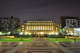
Butler Library at Columbia University in Morningside Heights
-
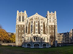
City College of New York in Hamilton Heights
-
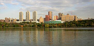
Columbia University Irving Medical Center in Washington Heights
-
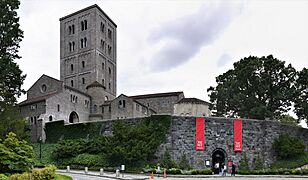
The Cloisters in Fort Tryon Park houses the medieval art collection of the Metropolitan Museum of Art.
-
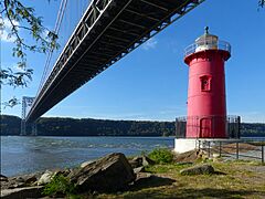
The Little Red Lighthouse under the George Washington Bridge
-
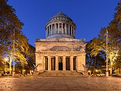
Grant's Tomb in Morningside Heights
-
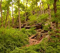
Inwood Hill Park contains the last remnant of the primeval forest which once covered Manhattan; these caves were used by native Lenape people.


See also
 In Spanish: Alto Manhattan para niños
