
Fort Tryon Park facts for kids
Quick facts for kids Fort Tryon Park |
|
|---|---|

(2013)
|
|
| Location | Hudson Heights/Inwood, Manhattan, New York |
| Area | 67.21 acres (27 ha) |
| Elevation | 268 feet (82 m) |
| Created | 1935 |
| Designer | Olmsted Brothers |
| Etymology | Sir William Tryon |
| Operated by | NYC Parks |
| Open | 6 a.m. to 1 a.m. |
| Status | Open all year |
| Public transit access | Subway: Bus: M4, M98, M100, Bx7 |
|
Fort Tryon Park and the Cloisters
|
|

Location in New York City
|
|
| Location | bounded by 190th Street, Cabrini Boulevard, 192nd Street, Bennett Avenue, Broadway, Riverside Drive, and Henry Hudson Parkway Manhattan, New York City |
| Area | 66.5 acres (26.9 ha) |
| Built | 1935 |
| Architect | Olmsted Brothers: (Frederick Law Olmsted, Jr., James W. Dawson) |
| Architectural style | Romanesque |
| NRHP reference No. | 78001870 |
| Significant dates | |
| Added to NRHP | December 19, 1978 |
Fort Tryon Park is a large public park in Manhattan, New York City. It is located in the Hudson Heights and Inwood neighborhoods. The park covers about 67 acres (27 hectares) and sits on a high ridge. It offers amazing views of the Hudson River and the surrounding areas. The main entrance is at Margaret Corbin Circle.
This area was once called Chquaesgeck by the local Lenape tribe. Dutch settlers later called it Lange Bergh (Long Hill). During the American Revolutionary War, a big battle, the Battle of Fort Washington, happened here. For many years, the area was mostly empty. By the early 1900s, it had large country homes.
In 1917, a rich person named John D. Rockefeller, Jr. started buying these homes. He wanted to create Fort Tryon Park. He hired the famous Olmsted Brothers firm to design the park. They also hired James W. Dawson to plan all the plants. Rockefeller gave the land to New York City in 1931. The park was finished and opened in 1935.
Rockefeller also bought a huge collection of medieval art from sculptor George Gray Barnard. He gave this art to the Metropolitan Museum of Art. From 1935 to 1939, the museum built the Cloisters right inside Fort Tryon Park to show this collection.
The park is built on a high rock formation called Manhattan schist. You can see marks from the last Ice Age on the rocks. The park has many beautiful gardens, like the Heather Garden. This garden was fixed up in the 1980s. Besides the gardens and the Cloisters, the park has lots of walking paths and open grassy areas. You can see both the Hudson and Harlem Rivers from here. Fort Tryon Park was added to the National Register of Historic Places in 1978. It became a New York City Scenic Landmark in 1983.
Contents
What is the Geography and Geology of Fort Tryon Park?
Fort Tryon Park covers about 67 acres. It is next to the Henry Hudson Parkway on the west and Broadway on the east. To the north, it is near Inwood Hill Park. To the south, it is close to Fort Washington Park. All these parks are part of the Manhattan Waterfront Greenway.
From the park, you can see the Hudson River and the George Washington Bridge. You can also see the New Jersey Palisades to the west. To the north, you can see Inwood and the Bronx. The Harlem River is visible to the east.
The park sits on a type of rock called Manhattan schist. You can see examples of glacial striations, which are scratches left by glaciers from the last Ice Age. There is also a large hole in the rock made by a glacier, called a glacial pothole.
The northern edge of the park has a fault line called the Dyckman Street Fault. This fault creates a valley that separates Fort Tryon Park from Inwood Hill Park. Long ago, Native Americans used a road in this valley.
How Was Fort Tryon Park Designed?


The Olmsted Brothers designed Fort Tryon Park to fit the area's steep hills. Their plan from 1927 aimed for a "landscape park" with beautiful views. It was mostly for quiet activities, except for a playground at the north end. The park's design also made the Cloisters a main feature.
The designers kept the natural shape of the land. They believed the park should have many different kinds of landscapes. This included distant views of the Hudson River and the city. They wanted some areas to feel private and detailed, while others were grand and simple.
The park has many paths and a mix of natural and man-made slopes. They added plants and rocks to make the park even more beautiful. Flat areas were turned into lawns with trees. Stone walls were built along slopes to keep visitors safe. The park also has curved roads and paths for walking and driving.
Other design features include arches and different types of gardens. The park mixes natural areas with architectural parts. This is similar to other parks designed by Olmsted's father, like Morningside Park.
However, Fort Tryon Park was different from earlier Olmsted parks. It had more architectural features and was more friendly to cars. The stone walls were very noticeable. The Cloisters was the most important building in the park. It also had parking lots and places for cars to stop and enjoy the view. This was new, as other parks tried to limit cars.
What Roads and Paths are in Fort Tryon Park?

Fort Tryon Park has several roads for light traffic. The main road is Margaret Corbin Drive. It goes from the park's southern entrance at Corbin Circle to a loop around the Cloisters. This road was named in 1977 after Margaret Corbin, a soldier in the American Revolutionary War.
Another road, Fort Tryon Place, connects to the Henry Hudson Parkway. Margaret Corbin Drive goes over Fort Tryon Place using two stone arches. The park also has many small parking lots.
There is an 8-mile (13 km) network of walking paths in the park. Some paths have rows of cut stones that look natural. Tunnels carry paths under the roads in two spots. Ramps and stairs connect the park to Broadway and Riverside Drive. A formal walkway with benches and trees goes from Corbin Circle to Linden Terrace.
What Kinds of Plants Grow in Fort Tryon Park?

The park was originally planted with many trees, both native and from other places. The Olmsted Brothers brought in 180 full-grown trees. They also planted over 1,600 types of flowers to make the park look like a botanical garden. Different parts of the park have plants that bloom in different seasons.
There are also small lawns, like the Children's Play Lawn and the Picnic Grounds. The Heather and Alpine Gardens were designed with a huge variety of plants. It is against the rules to pick plants in any New York City park.
The Heather Garden is a very large public garden, about 3 acres (1.2 hectares) in size. It was planned with American elm trees and low-growing heather. The short heather allows for clear views of the Hudson River. Stone benches let visitors sit and enjoy the scenery. This garden was fixed up in the late 1980s to match the original plans. It has plants that bloom in every season.
The Alpine Garden is another special garden. It is located on a ridge on the park's eastern side, near the Cloisters. This garden has a stone staircase and a small cave. It was restored in 2009. The garden uses many rocks, which go well with the natural rock formations. These rocks include quartz, feldspar, mica, and garnet. Some stones came from digging during the park's and subway's construction.
The Cabrini Woods Nature Sanctuary is in the park's southwest corner. These woods connect to Inwood Hill Park and Fort Washington Park. These are the last two natural woodlands in Manhattan. The woods are home to many animals, including 80 bird species, possums, raccoons, and skunks.
What Playgrounds are in Fort Tryon Park?
_009_-_Anne_Loftus_Playground.jpg)
Fort Tryon Park has two playgrounds. The Anne Loftus Playground is in the park's northeast corner. It is named after Anne Susan Cahill Loftus, a local community leader. Opened in 1934, it was the only part of the park meant for active play. It was also the only playground designed by the Olmsted Brothers. The playground has a stone building with a rooftop viewing deck. It also has a large wading pool and plane trees. This playground was updated in 1995-1997.
The other playground is the Jacob K. Javits Playground. It is named after U.S. senator Jacob Javits. This play area has play structures and basketball courts. It was given to the city in 1944 and renamed in 1984. It was renovated in 1995 and again starting in 2019.
What Other Features Does Fort Tryon Park Have?

Corbin CircleMargaret Corbin Circle is at the park's southern edge. It is a roundabout for cars. The old Fort Tryon Cottage and the entrance to the New York City Subway's 190th Street station are nearby. A bronze plaque honors Margaret Corbin here.
Sir William's Dog Run is a special area for dogs. It is open 24 hours a day. Dogs can run off-leash here. It opened in 2001 and is one of the biggest dog runs in Manhattan.
What Buildings are in Fort Tryon Park?
Buildings in Fort Tryon Park include the Cloisters, a gatehouse, a cafeteria, and other structures. Most of these buildings are made of stone.
What is The Cloisters?


The Cloisters is a part of the Metropolitan Museum of Art. It holds a huge collection of art and items from medieval Europe. This includes the famous Unicorn Tapestries. The museum buildings are a mix of real medieval structures brought from Europe and new buildings designed to look medieval.
The Cloisters has four main cloister (courtyard) structures: Cuxa, Saint Guilhem, Bonnefont, and Trie. It also has three gardens. The museum is surrounded by the park's circular drive.
John D. Rockefeller Jr. bought a medieval art collection and gave it to the Met. He thought Fort Tryon Park was the perfect place for it. The Met then built the Cloisters with money from Rockefeller. The Cloisters opened in 1938. A northern part, The Fuentidueña Apse, was added in 1961.
What is Linden Terrace?

The David Rockefeller Linden Terrace is at the northern end of the Promenade. It is where Fort Tryon and Tryon Hall once stood. The terrace is 268 feet (82 meters) above sea level. This makes it the highest landscaped spot on Manhattan Island.
Linden Terrace is supported by stone walls up to 40 feet (12 meters) tall. It has a main viewing area and a smaller Northeast Terrace. These are connected by an arch. In the early 2000s, the terrace was renamed after David Rockefeller, who gave $1 million to the park.
The main part of the terrace has a seating area with elm trees. There are plaques honoring John Rockefeller Jr.'s gift of the park and David Rockefeller's donation. The Northeast Terrace has a flagstaff with a granite and bronze base. The original flagstaff was knocked down by Hurricane Sandy in 2012 and later replaced.
A stone monument called the Fort Tryon Memorial is on the wall north of Linden Terrace. It was put there in 1904 or 1909. It remembers Margaret Corbin and the soldiers who fought there in 1776.
What are the Billings Estate Remnants?


There are several parts left from the old C. K. G. Billings estate. The Fort Tryon Cottage was originally a gatehouse for the estate. It is a three-story building with a dining room and kitchen. Today, it is the northern Manhattan headquarters for NYC Parks. It is usually closed to the public.
You can also see parts of the old red-brick pathways near Corbin Circle. This was once a long, winding driveway for horses. It went down to Riverside Drive. The brick helped horses climb the steep slope. The gates to the driveway are gone, but the granite posts are still there.
The driveway went through a huge arched structure called the Billings Arcade. This arcade has five 50-foot (15-meter) tall arches made of granite. On top of the arcade is a small grassy area called the Billings Lawn. The arcade cost a lot of money to build.
What is the Concession Building?

The park's concession building is north of Margaret Corbin Circle. It is a two-story stone building with a slate roof. It has open areas on most sides. The main entrance has three arches. This building used to have a cafe, restrooms, and offices for park staff.
The building was closed after a fire in 1976. It was fixed up starting in 1995 by a group called NYRP. They opened the New Leaf Café there in 2001. The building closed again for roof repairs in 2014. A new cafe, Coffeed, took over the restaurant in 2015.
What Other Structures are in the Park?

The Shelter Overlook is an eight-sided gazebo. It is near Sir William's Dog Run. It has a roof supported by stone pillars. People using the dog run often visit the gazebo.
There is also a two-story brick building for the subway's ventilation. The park has two restrooms. One looks like a small house, and the other is built into a slope.
What Wildlife Can You See in Fort Tryon Park?
Cabrini Woods is home to 80 types of birds. You might also see possums, raccoons, and skunks. The area has many common birds like blue jays and cardinals. You might even spot wild turkeys or birds of prey like red-tailed hawks and owls. Other animals include voles, salamanders, flying squirrels, and cottontail rabbits.
Who Manages Fort Tryon Park?
The Fort Tryon Park Trust is a group that helps take care of and improve Fort Tryon Park. It started in 1998. Their goal is to "promote the restoration, preservation, and enhancement of this historic and scenic landmark." They work to make the park better for everyone who visits. The Trust has received many grants to help maintain different parts of the park.
How Can You Get to Fort Tryon Park?

The New York City Subway's IND Eighth Avenue Line (A train) runs under Fort Tryon Park. There are two subway stations that serve the park. The Dyckman Street station is at the park's northeast corner. The 190th Street station is at Corbin Circle, at the park's southeast end.
Several bus routes also serve Fort Tryon Park. The M4 and M98 buses end at Corbin Circle. The M4 bus even goes into the park to the Cloisters when the museum is open. The M100 and Bx7 buses stop along Broadway, on the park's eastern side.
Why is Fort Tryon Park Important?
What is the Historic Importance of Fort Tryon Park?
People have found many old things in Fort Tryon Park since 1918. Archeologists found signs of old Native American camps, like shell piles and fireplaces. They found items from the 17th and 18th centuries, including things from the Revolutionary War.
The park and the Cloisters together were listed as a historic district in 1978. The Cloisters was named a New York City landmark in 1974. Fort Tryon Park was named a scenic landmark in 1983.
How Do People Use and See Fort Tryon Park?
In 2012, a study of social media messages found that Fort Tryon Park was "the happiest spot in Manhattan." Because it is a bit hidden, many people use the park for wedding photos and ceremonies.
The Fort Tryon Park Trust helps fund programs for all ages. These include yoga and tai chi classes, outdoor concerts, and bird walks. The Trust also supports local artists who display their work in the park.
Fort Tryon Park also hosts several yearly events. The Medieval Festival happens every September and brings in about 60,000 people. Open House New York offers tours of the Billings cottage and Heather Garden each October. Other events include the "Shearing of the Heather" in April and the "Urban Wildlife Festival."
Has Fort Tryon Park Been in Movies?
Several movies have filmed scenes in Fort Tryon Park or the Cloisters. In 1948, the film Meditation on Violence used the Cloisters. The movie Portrait of Jennie (also 1948) used the Cloisters as a school. Scenes from the 1968 film Coogan's Bluff were filmed in the park's Heather Garden. Parts of the 2011 movie The Adjustment Bureau were also filmed in Fort Tryon Park.
Images for kids
-
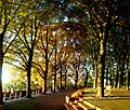
Linden Terrace, located on the site of Fort Tryon
-
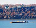
The view from Linden Terrace to the west: a barge on the Hudson River and the Hudson Palisades beyond, with the Englewood Cliffs campus of Saint Peter's University on the top
-
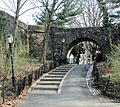
Archway and path under Linden Terrace
-
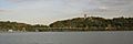
A view of the park from the Hudson River; The Cloisters can be seen at the top of the hill on the right. The green elevated highway is the Henry Hudson Parkway
-
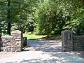
One of the park's entrances


See also
 In Spanish: Fort Tryon Park para niños
