Woolwich Township, New Jersey facts for kids
Quick facts for kids
Woolwich Township, New Jersey
|
||
|---|---|---|
|
Township
|
||
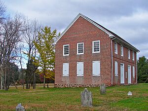
Historic Moravian Church
|
||
|
||
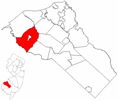
Woolwich Township highlighted in Gloucester County. Inset map: Gloucester County highlighted in New Jersey.
|
||
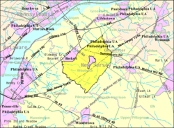
Census Bureau map of Woolwich Township, New Jersey
|
||
| Country | ||
| State | ||
| County | ||
| Royal charter | March 7, 1767 | |
| Incorporated | February 21, 1798 | |
| Named for | Woolwich, England | |
| Government | ||
| • Type | Township | |
| • Body | Township Committee | |
| Area | ||
| • Total | 21.39 sq mi (55.41 km2) | |
| • Land | 21.07 sq mi (54.58 km2) | |
| • Water | 0.32 sq mi (0.83 km2) 1.50% | |
| Area rank | 132nd of 565 in state 5th of 24 in county |
|
| Elevation | 66 ft (20 m) | |
| Population
(2020)
|
||
| • Total | 12,577 | |
| • Estimate
(2023)
|
13,839 | |
| • Rank | 203rd of 565 in state 9th of 24 in county |
|
| • Density | 596.9/sq mi (230.5/km2) | |
| • Density rank | 430th of 565 in state 19th of 24 in county |
|
| Time zone | UTC−05:00 (Eastern (EST)) | |
| • Summer (DST) | UTC−04:00 (Eastern (EDT)) | |
| ZIP Code |
08085 – Swedesboro
|
|
| Area code(s) | 856 Exchanges: 241, 467 | |
| FIPS code | 3401582840 | |
| GNIS feature ID | 0882144 | |
| Website | ||
Woolwich Township is a community in Gloucester County, New Jersey. It's part of the larger Philadelphia metropolitan area. In 2020, about 12,577 people lived here. This was a big jump from 2010, when the population was 10,200. Woolwich Township is located in an area called South Jersey.
Contents
A Look Back in Time
Woolwich Township was officially created a long time ago. It was formed by a special order from the king on March 7, 1767. Later, on February 21, 1798, it became one of New Jersey's first 104 townships.
Over the years, parts of Woolwich Township were used to create other towns. These include Franklin Township in 1820 and Harrison Township in 1844. Also, Logan Township was formed in 1877, and Swedesboro in 1902. The township was named after Woolwich, a place in England.
Where is Woolwich?
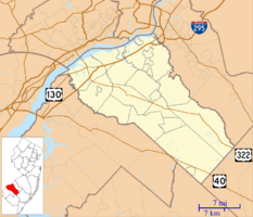
Woolwich Township covers about 21.39 square miles (55.41 square kilometers). Most of this area is land. A small part, about 0.32 square miles (0.83 square kilometers), is water.
Did you know that Swedesboro is a town completely surrounded by Woolwich Township? This makes it one of New Jersey's "doughnut towns." Woolwich Township also shares borders with other towns in Gloucester County. These include East Greenwich Township and Harrison Township. It also borders Logan Township, Oldmans Township, Pilesgrove Township, and South Harrison Township.
You can find several smaller communities and places within Woolwich Township. Some of these are Asbury, Dilkes Mills, and Lippencott. Other spots include Porches Mill, Robbins, Rulons, and Scull.
How Many People Live Here?
Woolwich Township has grown a lot over the years. In 2000, only 3,032 people lived here. By 2010, the population jumped to 10,200. The latest count in 2020 showed 12,577 residents. Experts estimate that the population grew to about 13,839 by 2023.
A Closer Look at the Population
In 2010, there were 10,200 people living in Woolwich Township. Most residents, about 81%, were White. About 10% were Black or African American, and 6% were Asian. People from two or more races made up about 2% of the population. About 3.6% of the population was Hispanic or Latino.
Many households in Woolwich Township had children under 18. About 78% of households were married couples living together. The average household had about 3.21 people. The average family size was 3.46 people.
The median age of people in Woolwich Township was 35.7 years. About 33.5% of the population was under 18 years old. About 6.4% of residents were 65 years or older.
Local Economy
Woolwich Township is planning for future growth. Near New Jersey Turnpike exit 2, there are plans for new shopping and business areas. This development will include retail stores, offices, and other commercial spaces. These plans aim to help the local economy grow.
Education for Kids
Students in Woolwich Township attend public schools. Children from pre-kindergarten to sixth grade go to schools in the Swedesboro-Woolwich School District. This district serves students from both Swedesboro and Woolwich Township.
The district has four schools:
- Margaret C. Clifford School (Pre-K to Kindergarten)
- Governor Charles C. Stratton School (Grades 1-2)
- General Charles G. Harker School (Grades 3-5)
- Walter H. Hill School (Grade 6)
Older students, from seventh to twelfth grade, attend the Kingsway Regional School District. This district also includes students from nearby towns like East Greenwich Township and Swedesboro. Woolwich Township students make up a big part of this district.
The Kingsway Regional School District has two main schools:
- Kingsway Regional Middle School (Grades 7-8)
- Kingsway Regional High School (Grades 9-12)
Students from across Gloucester County can also apply to the Gloucester County Institute of Technology. This high school offers special technical and vocational training. It's a public school, so students don't pay tuition.
For those interested in private education, Guardian Angels Regional School is a Catholic school. It serves students from kindergarten through eighth grade.
Getting Around
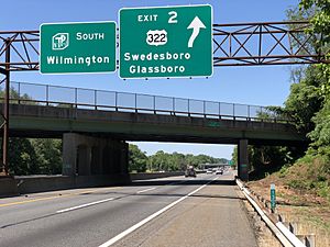
Woolwich Township has many roads to help people travel. There are over 93 miles of roadways in total. Some roads are maintained by the township, others by Gloucester County, and some by the state.
A major road, U.S. Route 322, goes right through the middle of the township. The New Jersey Turnpike also passes through the southeastern part of Woolwich. You can get onto Route 322 from Turnpike Exit 2. Other important county roads include County Road 538 and County Road 551.
If you need to use public transportation, NJ Transit offers bus service. The 401 route connects Salem, New Jersey, to Philadelphia.
Local Wineries
Woolwich Township is home to DiBella Winery. It's a place where grapes are grown and wine is made.
Community Life
Woolwich Township has been recognized as a growing community. In 2005, The Philadelphia Inquirer called it the "Number 1 Area Boomtown." This means it was a fast-growing area.
Historic Places to Visit
Woolwich Township has several interesting historic sites:
- Gov. Charles C. Stratton House: This house was built in 1791. It was once the home of New Jersey Governor Charles C. Stratton. It became a historic place in 1973.
- Moravian Church: This historic church building was built in 1786. It was added to the National Register of Historic Places in 1973.
- Mount Zion African Methodist Episcopal Church and Mount Zion Cemetery: Built in 1834, this church is also a historic site. It was important in the Underground Railroad in South Jersey, helping people find freedom.
Famous People from Woolwich
Many notable people have connections to Woolwich Township:
- Jason Babin (born 1980), a former football player for the Philadelphia Eagles.
- Marlon Byrd (born 1977), a baseball outfielder who played for the Philadelphia Phillies.
- Hank Fraley (born 1977), a former football offensive lineman for the Cleveland Browns.
- Ellis Hobbs (born 1983), a former football cornerback for the Philadelphia Eagles.
- Michael McCary (born 1971), a former bass singer from the R&B group Boyz II Men.
- Kenneth Lacovara (born 1961), a paleontologist famous for discovering the dinosaur Dreadnoughtus.
- Jason Peters (born 1982), a football offensive tackle for the Philadelphia Eagles.
- Jimmy Rollins (born 1978), a Major League Baseball shortstop, well-known for his time with the Philadelphia Phillies.
- Adam Taliaferro (born 1982), a former college football player who later served in the New Jersey General Assembly.
See also
 In Spanish: Municipio de Woolwich para niños
 | Toni Morrison |
 | Barack Obama |
 | Martin Luther King Jr. |
 | Ralph Bunche |


